
A tunnel is an underground passageway, dug through surrounding soil, earth or rock, and enclosed except for the entrance and exit, commonly at each end. A pipeline is not a tunnel, though some recent tunnels have used immersed tube construction techniques rather than traditional tunnel boring methods.
Welland is a city in the Regional Municipality of Niagara in Southern Ontario, Canada. As of 2021, it had a population of 55,750.

The Welland Canal is a ship canal in Ontario, Canada, connecting Lake Ontario and Lake Erie. It forms a key section of the St. Lawrence Seaway and Great Lakes Waterway. Traversing the Niagara Peninsula from Port Weller in St. Catharines to Port Colborne, it enables ships to ascend and descend the Niagara Escarpment and bypass Niagara Falls. It is the fourth canal connecting these waterways; three smaller predecessors also bore the same name.

The National Water Carrier of Israel is the largest water project in Israel, completed in 1964. Its main purpose is to transfer water from the Sea of Galilee in the north of the country to the highly populated center and arid south and to enable efficient use of water and regulation of the water supply in the country. Up to 72,000 cubic meters of water can flow through the carrier each hour, totalling 1.7 million cubic meters in a day.

Dain City is a small suburb at the southernmost part of Welland, Ontario, Canada. At one time, it was a mostly self-contained rural community at the junction of two significant rail lines, part of the Township of Humberstone, and was called Welland Junction. The name was changed to Dain City after it was annexed to the city of Welland in the mid-1950s. Dain City was built for, and by, the Marshall Dain Manufacturing Company, the area's main employer, as a "company town".
King's Highway 140, commonly referred to as Highway 140, is a provincially maintained highway in the Canadian province of Ontario. The highway connects Port Colborne near Lake Erie with Highway 406 in Welland, via the Main Street Tunnel. It was constructed in the early 1970s as part of the Welland Bypass project of the Welland Canal, which resulted in the severance of several highways and rail lines. Opened to traffic in late 1972, several months following the tunnel, Highway 140 has remained unchanged since, despite growing calls to resign it as an extension of Highway 406.

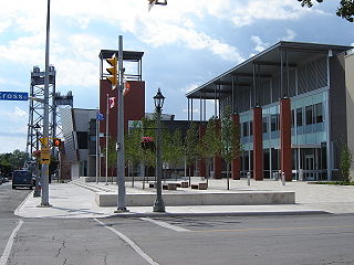
The Main Street Tunnel, located in Welland, Ontario, Canada, is an underwater tunnel, carrying Niagara Road 27 and the unsigned designation of Highway 7146 under the Welland Canal. It is named as a part of East Main Street.

The Welland By-pass, completed in 1973, was a massive construction project on the Welland Canal in Ontario, Canada.

The Welland Recreational Waterway is a water channel in the city of Welland, Ontario, Canada. It is an old alignment of the Welland Ship Canal that was abandoned after the construction of the Welland By-Pass in the 1970s. The Waterway is now managed by the Welland Recreational Canal Corporation to provide enjoyment for the city's residents. Most local residents refer to it as the old canal or simply the canal.

The Robert-Bourassa generating station, formerly known as La Grande-2 (LG-2), is a hydroelectric power station on the La Grande River that is part of Hydro-Québec's James Bay Project in Canada. The station can generate 5,616 MW and its 16 units were gradually commissioned between 1979 and 1981. Annual generation is in the vicinity of 26500 GWh.

Sir Adam Beck Hydroelectric Generating Stations are two hydroelectric generating stations in Niagara Falls, Ontario, Canada. Sir Adam Beck Generating Station I, Sir Adam Beck Generating Station II and the Sir Adam Beck Pump Generating Station are all owned by Ontario Power Generation. Following the development of several smaller generating stations around Niagara Falls in the late 19th and early 20th centuries, the Province of Ontario authorized the construction of the first major publicly owned generating station in the province. At the time it was built, it was the largest hydroelectric generating station in the world.
King's Highway 58A, commonly referred to as Highway 58A, is a provincially maintained highway in the Canadian province of Ontario. The short route serves to connect Highway 58 with Highway 140 and passes beneath the Welland Canal through the Townline Tunnel. The entire route is located within the city of Welland in the Regional Municipality of Niagara.

The Ffestiniog Power Station is a 360 megawatts pumped-storage hydroelectricity scheme near Ffestiniog, in Gwynedd, north-west Wales. The power station at the lower reservoir has four water turbines, which can generate 360 MW of electricity within 60 seconds of the need arising. The scheme has a storage capacity of around 1.44 GWh (5.2 TJ) at maximum output for four hours, and the capacity to power the whole of North Wales for several hours.

Chipping Sodbury Tunnel is a railway tunnel that is situated on the South Wales Main Line in England. It runs under the Cotswold Hills some 2+1⁄2 miles (4.0 km) west of Badminton railway station and Chipping Sodbury Yard.

The Welland Canal Bridge 15 is a two-track Baltimore truss swing bridge located in the disused section of the Welland Canal within the city of Welland, Ontario. This section of canal is now known as the Welland Recreational Waterway. The bridge formerly carried the main line of the Canada Southern Railway (CASO) over the canal.

The Welland Canal - bridge 13, or as more commonly known locally, the Welland bridge is a vertical lift bridge located in the heart of downtown Welland, Ontario. The bridge crosses an abandoned portion of the Welland Canal known as the Welland Recreational Waterway.
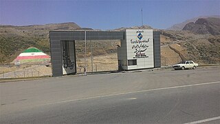
The Siah Bisheh Pumped Storage Power Plant, also spelled Siyāhbisheh and Siah Bishe, is located in the Alborz Mountain range near the village of Siah Bisheh and 48 km (30 mi) south of Chalus in Mazandaran Province, Iran. The power plant uses the pumped-storage hydroelectric method to generate electricity during periods of high energy demand, making it a peaking power plant, intended to fulfill peak electricity demand in Tehran 60 km (37 mi) to the south. When complete it will have an installed generating capacity of 1,040 megawatts (1,390,000 hp) and a pumping capacity of 940 megawatts (1,260,000 hp). Planning for the project began in the 1970s and construction began in 1985. It was delayed from 1992 until 2001 and the first generator went online in May 2013. The remaining generators were commissioned by 1 September 2015. The power plant is the first pumped-storage type in Iran and will also use the country's first concrete-face rock-fill dam – two of them.

Idamalayar Dam is a multipurpose concrete gravity dam located at Ennakkal between Ayyampuzha and Bhoothathankettu in Ernakulam district of Kerala on the Idamalayar, a tributary of the Periyar River in Kerala, South India. The dam however extends east as far as Malakkappara. Completed in 1985, with a length of 373 metres (1,224 ft) and a height of 102.8 metres (337 ft), the dam created a multipurpose reservoir covering 28.3 km2 (10.9 sq mi) in the scenic hills of the Anamalais.

Zengwen Dam, also spelled Tsengwen Dam, is a major earthen dam in Dapu Township, Chiayi County, Taiwan on the Zengwen River. It is the third tallest dam in Taiwan, and forms Zengwen Reservoir (曾文水庫), the biggest reservoir in Taiwan by volume. The dam stores water for irrigation of the Chianan Plain, Taiwan's most productive agricultural region, and provides flood control along the Zengwen River which flows through Tainan City. The dam supports a 50 megawatt hydroelectric power station.
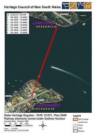
Sydney Harbour railway electricity tunnel is heritage-listed electricity infrastructure running under Sydney Harbour between Birchgrove and Greenwich, Sydney, New South Wales, Australia. It is also known as Balmain to Greenwich Electric Cable Tunnel. It was added to the New South Wales State Heritage Register on 2 April 1999.

