Emo | |
---|---|
Township of Emo | |
Coordinates: 48°38′N93°50′W / 48.633°N 93.833°W | |
Country | Canada |
Province | Ontario |
District | Rainy River |
Settled | 1880s |
Incorporated | 1899 |
Government | |
• Type | Township |
• Mayor | Harold McQuaker |
• Federal riding | Thunder Bay—Rainy River |
• Prov. riding | Kenora—Rainy River |
Area | |
• Land | 203.09 km2 (78.41 sq mi) |
Population (2016) [2] | |
• Total | 1,333 |
• Density | 6.6/km2 (17/sq mi) |
Time zone | UTC-6 (CST) |
• Summer (DST) | UTC-5 (CDT) |
Postal code | P0W 1E0 |
Area code | 807 |
Website | www.emo.ca |
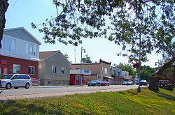
Emo is a small rural township, located along the Rainy River near the southwestern corner of northern Ontario, Canada, on the U.S. border directly north of the state of Minnesota. Emo had a population of 1,333 in the Canada 2016 Census.
It is known for its stock car races, its picturesque, family-friendly waterfront park, the annual Rainy River Agricultural Fair (cattle industry is key in the area) and the Emo Walleye Classic fishing tournament.
Emo was officially created on July 1, 1899, and celebrated its centennial in 1999. Emo's first reeve was Alexander Luttrell, an Irishman who named the town after a namesake village in Ireland near where he was born. The council was composed of Charles Fisher, John Dungey, Benjamin Phillips, and Thomas Shortreed. [3]
The post office, Emo River, dates from 1887. [4]
Emo has a four-season humid continental climate with extreme temperature differences between summer and winter. The daily mean difference between January and July is as much as 34 °C. [5]
Climate data for Emo | |||||||||||||
---|---|---|---|---|---|---|---|---|---|---|---|---|---|
Month | Jan | Feb | Mar | Apr | May | Jun | Jul | Aug | Sep | Oct | Nov | Dec | Year |
Record high °C (°F) | 7.5 (45.5) | 13.0 (55.4) | 20.0 (68.0) | 32.0 (89.6) | 32.5 (90.5) | 37.0 (98.6) | 36.0 (96.8) | 35.0 (95.0) | 33.5 (92.3) | 29.0 (84.2) | 22.0 (71.6) | 9.0 (48.2) | 37.0 (98.6) |
Mean daily maximum °C (°F) | −9.4 (15.1) | −5.3 (22.5) | 1.5 (34.7) | 10.7 (51.3) | 18.4 (65.1) | 22.9 (73.2) | 25.3 (77.5) | 24.5 (76.1) | 18.1 (64.6) | 10.3 (50.5) | 0.2 (32.4) | −7.8 (18.0) | 9.1 (48.4) |
Daily mean °C (°F) | −16.1 (3.0) | −12.3 (9.9) | −5.0 (23.0) | 3.5 (38.3) | 10.8 (51.4) | 15.5 (59.9) | 18.4 (65.1) | 17.4 (63.3) | 11.7 (53.1) | 4.8 (40.6) | −4.4 (24.1) | −13.2 (8.2) | 2.6 (36.7) |
Mean daily minimum °C (°F) | −22.7 (−8.9) | −19.2 (−2.6) | −11.7 (10.9) | −3.7 (25.3) | 3.1 (37.6) | 8.6 (47.5) | 11.4 (52.5) | 10.4 (50.7) | 5.2 (41.4) | −0.7 (30.7) | −9.0 (15.8) | −18.7 (−1.7) | −3.9 (24.9) |
Record low °C (°F) | −49.0 (−56.2) | −49.0 (−56.2) | −43.0 (−45.4) | −27.5 (−17.5) | −11.0 (12.2) | −3.5 (25.7) | −0.5 (31.1) | −3.5 (25.7) | −7.5 (18.5) | −20.0 (−4.0) | −44.0 (−47.2) | −46.0 (−50.8) | −49.0 (−56.2) |
Average precipitation mm (inches) | 32.5 (1.28) | 24.4 (0.96) | 31.6 (1.24) | 45.4 (1.79) | 78.3 (3.08) | 130.0 (5.12) | 110.0 (4.33) | 85.0 (3.35) | 82.6 (3.25) | 62.2 (2.45) | 51.9 (2.04) | 35.5 (1.40) | 769.4 (30.29) |
Average snowfall cm (inches) | 32.2 (12.7) | 20.9 (8.2) | 21.3 (8.4) | 12.9 (5.1) | 1.3 (0.5) | 0.0 (0.0) | 0.0 (0.0) | 0.0 (0.0) | 1.3 (0.5) | 10.0 (3.9) | 36.5 (14.4) | 33.9 (13.3) | 170.3 (67) |
Average precipitation days | 10 | 9 | 8 | 12 | 14 | 13 | 12 | 12 | 13 | 12 | 11 | 12 | 138 |
Source: Environment Canada [6] |
Emo is located in the Rainy River District. The current serving (acclaimed) mayor is Harold McQuaker, while Lisa Teeple, Harrold Boven, Phil Whatley, and Gerald Weiringa serve as councillors. Elections are held every four years, in October. Emo has been a source of controversy in the past, as it refused in 2020 to declare Pride Week or fly a pride flag. Mayor McQuaker, councillor Boven and former councillor Warren Toles voted against the motion to declare Pride Week, while former councillors Lincoln Dunn and Loriann Shortreed voted in favour. [7] Subsequently, a complaint was filed against the Township and the three councillors with the Ontario Human Rights Tribunal, which is ongoing, and has cost Emo taxpayers an estimated $100,000 in legal fees, including the legal fees of the three council members named in the complaint. [8]
Emo is about halfway between two bridges to the United States, one at Fort Frances (approximately a 30-minute drive) and the other at Rainy River (about 40 minutes by road). It is identified in many cycling resources as an excellent overnight stopping point because of the facilities (shelter, showers and bathrooms) available in the waterfront park.
There are many volunteer groups and a strong sense of community in Emo. In Emo's Lion's Park, a picturesque riverfront area, a new play structure was funded through volunteer fundraising efforts, and a 2005-2006 fiscal year grant from the Ontario Trillium Foundation . The park is also home to the Emo Spray Park, a $500,000 community-driven project completed in July 2010. A safe way for kids to engage in water play, the spray park attracts thousands of visitors in the summertime.
The spring brings the opening of the walleye fishing season, and the annual Emo Walleye Classic.
The Emo Speedway draws race participants and fans from the central United States, Northwestern Ontario and Manitoba. The track is a 600-metre, high-banked dirt oval track which operates every Saturday from May through Mid-September.
Emo is also home to four different religious denominations, including Knox United Church of Canada, [9] as well as Baptist, Catholic, and Christian Reformed churches.
The Emo Food Bank and Thrift Shop, located in what was formerly the Anglican Church, helps hundreds of area residents in need every year.
Initially located in private homes of local women, the town library was moved to the schoolhouse in 1940 and to its own building in the 50s.
Year | Pop. | ±% |
---|---|---|
1991 | 1,275 | — |
1996 | 1,366 | +7.1% |
2001 | 1,331 | −2.6% |
2006 | 1,305 | −2.0% |
2011 | 1,252 | −4.1% |
2016 | 1,333 | +6.5% |
[10] [2] |
In the 2021 Census of Population conducted by Statistics Canada, Emo had a population of 1,204 living in 472 of its 521 total private dwellings, a change of -9.7% from its 2016 population of 1,333. With a land area of 202.28 km2 (78.10 sq mi), it had a population density of 6.0/km2 (15.4/sq mi) in 2021. [11]
2021 | 2016 | 2011 | |
---|---|---|---|
Population | 1,204 (-9.7% from 2016) | 1,333 (+6.5% from 2011) | 1,252 (-4.1% from 2006) |
Land area | 202.28 km2 (78.10 sq mi) | 203.09 km2 (78.41 sq mi) | 203.54 km2 (78.59 sq mi) |
Population density | 6/km2 (16/sq mi) | 6.6/km2 (17/sq mi) | 6.2/km2 (16/sq mi) |
Median age | 41.2 (M: 41.2, F: 41.2) | 40.5 (M: 39.3, F: 41.1) | 41.4 (M: 40.3, F: 41.9) |
Private dwellings | 521 (total) 472 (occupied) | 554 (total) | 483 (total) |
Median household income | $94,000 | $75,593 |
The Emo Walleye Classic is a two-day catch and release fishing tournament held annually in Emo, during the final week of May each year. [16] It takes place on the Rainy River, which marks the border between Minnesota and Ontario.
Upwards of sixty Canadian and American teams of two participate each year, each paying a participation fee ($500 in 2015). An organizing committee and many local volunteers assist at the event, and many local businesses and individuals sponsor the event. [16]
On each morning of the tournament, anglers head upstream and downstream from the Emo waterfront to their chosen fishing spots. The weigh-ins are held in the evenings at the Emo/LaVallee Community Centre where results are posted live. On the final day of the tournament, the top ten teams from day one are brought into the arena with their boats.
The tournament began in 2002 with forty-four participating teams, and has grown since then, with thirty-eight teams competing in 2013. The first winners were Harvey Cochrane and Oliver Gibbons who won as a result of the leading team having three fish over the legal size. In 2008 Doug McBride of Devlin, Ontario and Steve Ballan of Fort Frances, Ontario became the first team to win the tournament twice. [16]
2005 Tournament - Day 2 - Doug McBride and Steve Ballan: 10.02 lbs
2005 Tournament - Day 2 - Doug McBride and Steve Ballan: 15.06 lbs
2005 Tournament - Doug McBride and Steve Ballan: 25.82 lbs [16]
Caledon is a town in the Regional Municipality of Peel in the Greater Toronto Area of Ontario, Canada. The name comes from a shortened form of Caledonia, the Roman name for what is now Scotland. Caledon is primarily rural with a number of hamlets and small villages, but also contains the larger community of Bolton in its southeastern quadrant, adjacent to York Region. Some spillover urbanization also occurs in the south bordering the City of Brampton.
The City of Kawartha Lakes is a unitary municipality in Central Ontario, Canada. It is a municipality legally structured as a single-tier city; however, Kawartha Lakes is the size of a typical Ontario county and is mostly rural. It is the second largest single-tier municipality in Ontario by land area.
Essa is a township in Ontario, Canada, west and south of the city of Barrie in Simcoe County. It is bounded by County Road 90 to its north, County Road 27 to its east, and Ontario Highway 89 to its south. The township is about 100 kilometres (62 mi) from Toronto. The township is well known for its agriculture industry, particularly potato farming. Nearby CFB Borden brings a strong military presence to the area as well, including a high number of Francophone families.
The Township of Muskoka Lakes is a municipality of the District Municipality of Muskoka, Ontario, Canada. It has a year-round population of 7,652.
Kincardine is a municipality located on the shores of Lake Huron in Bruce County in the province of Ontario, Canada. The current municipality was created in 1999 by the amalgamation of the Town of Kincardine, the Township of Kincardine, and the Township of Bruce.
Rainy River District is a district and census division in Northwestern Ontario in the Canadian province of Ontario. It was created in 1885. It is the only division in Ontario that lies completely in the Central Time Zone, except for the township of Atikokan observing Eastern Standard Time for part of the year. Its seat is Fort Frances. It is known for its fishing and its location on the US border opposite International Falls, Minnesota, and Baudette, Minnesota.
Thunder Bay District is a district and census division in Northwestern Ontario in the Canadian province of Ontario. The district seat is Thunder Bay.
Springwater is a township in central Ontario, Canada, in Simcoe County, near Barrie. It is the county seat of Simcoe County.
Oliver Paipoonge is a township in the Canadian province of Ontario, located directly west of the city of Thunder Bay. The municipality was formed on January 1, 1998, with the amalgamation of the former Township of Oliver and Township of Paipoonge. It contains several communities within its boundaries, including Baird, Carters Corners, Harstone, Kakabeka Falls, Lee, McCluskeys Corners, Millar, Murillo, Rosslyn, Slate River Valley, Stanley and Twin City. The remainder of the municipality is agricultural or rural.
Guelph/Eramosa is a township located in Wellington County, in midwestern Ontario, Canada. It partly encircles the city of Guelph, surrounding it in a continuous arc from approximately northeast to south-southwest of the city. It is part of the Guelph census metropolitan area.
Shuniah is a municipal township bordering the city of Thunder Bay, Ontario, Canada on the east. Shuniah was incorporated by an act of the Ontario legislature in 1873, and at that time included much of present-day Thunder Bay and its predecessor and surrounding municipalities. It gradually shrunk in size until by 1936 it included only three wards, the geographic townships of McIntyre, McGregor, and McTavish. That year it had the Ontario Legislative Assembly remove a number of islands in Lake Superior that had formed the Island Ward since 1873. In 1970 McIntyre Township was amalgamated into the city of Thunder Bay. Shuniah, named after the Ojibwa word "zhooniyaa" for "money" or "silver", was settled largely due to silver mining potential identified in the mid-19th century.
South Stormont is a township in eastern Ontario, Canada, in the United Counties of Stormont, Dundas and Glengarry. It is located 53 kilometres (33 mi) southeast of Ottawa. South Stormont borders on, but does not include, the city of Cornwall.
Limerick is a small township in Hastings County, Ontario, Canada, near Limerick Lake. It is located 80 kilometres (50 mi) north of Belleville between Madoc and Bancroft and served by Ontario Highway 62 and Township Road 620. The Township is bordered by the Town of Bancroft, Township of Wollaston and the joined Townships of Tudor and Cashel. The township is heavily forested, as is the shoreline of the Limerick Lake, the main industry in the township being forestry and logging. The population of Limerick Township is approx. 300 full-year residents, and another 1000 seasonal residents.
Dawson is a township located in Rainy River District in Northwestern Ontario, Canada. The township is located at the mouth of the Rainy River where it flows into Lake of the Woods.
The Township of Alberton is a community in the Rainy River District of Northwestern Ontario, Canada. It is made up of the two geographic townships Crozier and Roddick. The township borders Fort Frances to the east, La Vallee to the west, the unincorporated geographical township of Miscampbell to the north, and the city of International Falls to the south.
Chapple is a township municipality in Rainy River District in Northwestern Ontario, Canada.
North Frontenac is a township in Frontenac County in eastern Ontario, Canada.
O'Connor is a township in the Canadian province of Ontario, located 32 kilometres (20 mi) west of the city of Thunder Bay. The municipality was formed on January 1, 1907. The township serves as a bedroom community of Thunder Bay, with some agriculture, and is part of Thunder Bay's Census Metropolitan Area.
Lake of the Woods is a township in the Canadian province of Ontario, located within the Rainy River District. The township is located on the eponymous Lake of the Woods, consisting of mainland in the south-east part of the lake, the southern shores of Aulneau Peninsula, along with several islands in the lake, including Big Island and Bigsby Island. It fully surrounds the Anishnaabeg of Naongashiing, Big Grassy River 35G, Big Island Mainland 93, and Saug-a-Gaw-Sing 1 First Nation reserves.
Unorganized Rainy River District is an unorganized area in the Rainy River District of Ontario, Canada, comprising all communities in the district which are not part of incorporated municipalities. Quetico Provincial Park is located entirely within this area.