Orillia is a city in Ontario, Canada, about 30 km north-east of Barrie in Simcoe County. It is located at the confluence of Lake Couchiching and Lake Simcoe. Although it is geographically located within Simcoe County, the city is a single-tier municipality. It is part of the Huronia region of Central Ontario. The population in 2021 was 33,411.

The District Municipality of Muskoka, more generally referred to as the District of Muskoka or Muskoka, is a regional municipality in Central Ontario, Canada. It extends from Georgian Bay in the west, to the northern tip of Lake Couchiching in the south, to the western border of Algonquin Provincial Park in the east. A two-hour drive north of Toronto, it spans 6,475 km2 (2,500 sq mi). It has some 1,600 lakes, making it a popular cottaging destination.

Ramara is a lower-tier township municipality in Simcoe County, Ontario, Canada.
Rainy River District is a district and census division in Northwestern Ontario in the Canadian province of Ontario. It was created in 1885. It is the only division in Ontario that lies completely in the Central Time Zone, except for the township of Atikokan observing Eastern Standard Time for part of the year. Its seat is Fort Frances. It is known for its fishing and its location on the US border opposite International Falls, Minnesota, and Baudette, Minnesota.
Treaty 3 was an agreement entered into on October 3, 1873, by Chief Mikiseesis on behalf of the Ojibwe First Nations and Queen Victoria. The treaty involved a vast tract of Ojibwe territory, including large parts of what is now northwestern Ontario and a small part of eastern Manitoba, to the Government of Canada. Treaty 3 also provided for rights for the Waasaakode Anishinaabe and other Ojibwe, through a series of agreements signed over the next year. The treaty was modified in 1875 when Nicolas Chatelain negotiated an adhesion that created a reserve, surveyed as reserve 16A, for Metis families connected to Mikiseesis' Rainy Lake Band. Reserve 16A and the Rainy Lake Band reserve were unified in 1967.
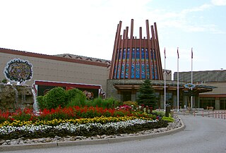
Rama is a First Nations community on the Chippewas of Rama First Nation reserve in Ontario, Canada. It is the home of Casino Rama.

The Treaty Three Police Service (T3PS) is a self-administered First Nation Police service in Ontario, serving all Treaty 3 First Nations.
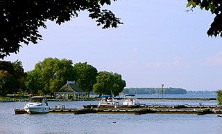
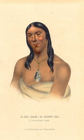
Chippewas of Rama First Nation, also known as Chippewas of Mnjikaning and Chippewas of Rama Mnjikaning First Nation, is an Anishinaabe (Ojibway) First Nation located in the province of Ontario in Canada. The name Mnjikaning, or fully vocalized as Minjikaning, refers to the fishing weirs at Atherley Narrows between Lake Simcoe and Lake Couchiching and it means "in/on/at or near the fence".

The Couchiching First Nation is a Saulteaux First Nation band government in the Canadian province of Ontario, who live on the Couchiching 16A and Agency 1 reserves in the Rainy River District near Fort Frances.
Agency 1 is a First Nations reserve in the Canadian province of Ontario in the northwest. As of 2021, there is no permanent population. The Indian reserve is shared among four First Nations: Couchiching First Nation, Mitaanjigamiing First Nation, Naicatchewenin First Nation and Nigigoonsiminikaaning First Nation.
Nigigoonsiminikaaning First Nation, formerly known as the Nicickousemenecaning First Nation and as the Red Gut First Nation, is a Saulteaux First Nation band government who inhabit the banks of Rainy Lake of the Rainy River District in Northwestern Ontario, Canada. As of January, 2008, the First Nation had a population of 290 registered people. As of 2017, it has approximately 130 on-reserve members.
Lac La Croix First Nation is a Saulteaux First Nation band government who reside in the Rainy River District of northwestern Ontario, Canada, along the Ontario-Minnesota border. It is approximately 200 km northwest of Thunder Bay, Ontario. As of January 2008, the First Nation had a registered population of 398 people, of which their on-Reserve population was 273.
The Naicatchewenin First Nation, also known as the Anishinaabeg of Nagaajiwanaang and formerly known as Northwest Bay First Nation, inhabited a region in Ontario that was cited in the Northwest Angle Treaty of 1873, also known as Treaty 3. Nagaajiwanaang is located approximately 60 kilometres (37 mi) northwest of Fort Frances, with the community of Devlin 50 kilometres (31 mi) to the south on Highway 11. The city of Thunder Bay lies 420 kilometres (260 mi) to the east and Winnipeg is 450 kilometres (280 mi) to the northwest.
Pwi-Di-Goo-Zing Ne-Yaa-Zhing Advisory Services is a non-profit Regional Chiefs' Council located in the Rainy River District, Ontario, Canada, serving seven First Nations by providing advisory services and training which will enhance the overall management skills and opportunities of the area's First Nations.
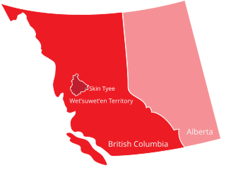
The Skin Tyee First Nation, also known as the Skin Tyee Indian Band is a First Nations band government located in the Central Interior of British Columbia near François Lake, in the Omineca Country to the west of the City of Prince George.
Rainy Lake and River Bands of Saulteaux are Saulteaux (Ojibwe) group located in Northwestern Ontario and northern Minnesota, along and about the Rainy Lake and the Rainy River, known in Ojibwe as Gojijiing.

Seine River First Nation, previously known as the Rivière la Seine Band, is an Ojibwe First Nation reserve located roughly 300 kilometres (190 mi) west of Thunder Bay, Ontario. As of November 2011, the First Nation had a total registered population of 725, of which 327 lived on their own reserve.
Big Grassy First Nation is an Ojibwe or Ontario Saulteaux First Nation band government located in Rainy River District, Ontario near Morson, Ontario.
Ojibways of Onigaming First Nation is an Ojibwe or Ontario Saulteaux First Nation located in Kenora District, Ontario near Nestor Falls, Ontario. Together with the Big Grassy First Nation, Ojibways of Onigaming First Nation is a successor apparent to the former Assabaska Band of Saulteaux. Total registered population in February, 2012, was 737, of which the on-reserve population was 445. The First Nation is a member of the Anishinabeg of Kabapikotawangag Resource Council, a regional tribal council that is a member of the Grand Council of Treaty 3.


