
Yukon is the smallest and westernmost of Canada's three territories. It is the third-least populated province or territory in Canada, with a population of 45,148 as of 2023. However, Whitehorse, the territorial capital, is the largest settlement in any of the three territories.

Dryden is the second-largest city in the Kenora District of Northwestern Ontario, Canada, located on Wabigoon Lake. It is the least populous community in Ontario incorporated as a city. The City of Dryden had a population of 7,749 and its population centre had a population of 5,586 in 2016.

The Saulteaux, otherwise known as the Plains Ojibwe, are a First Nations band government in Ontario, Manitoba, Saskatchewan, Alberta and British Columbia, Canada. They are a branch of the Ojibwe who pushed west. They formed a mixed culture of woodlands and plains Indigenous customs and traditions.
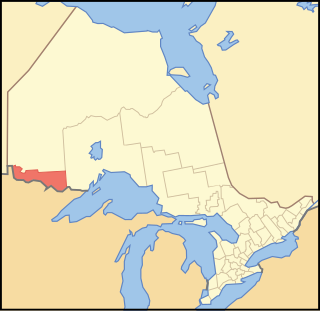
Rainy River District is a district and census division in Northwestern Ontario in the Canadian province of Ontario. It was created in 1885. It is the only division in Ontario that lies completely in the Central Time Zone, except for the township of Atikokan observing Eastern Standard Time for part of the year. Its seat is Fort Frances. It is known for its fishing and its location on the US border opposite International Falls, Minnesota, and Baudette, Minnesota.
Treaty 3 was an agreement entered into on October 3, 1873, by Chief Mikiseesis on behalf of the Ojibwe First Nations and Queen Victoria. The treaty involved a vast tract of Ojibwe territory, including large parts of what is now northwestern Ontario and a small part of eastern Manitoba, to the Government of Canada. Treaty 3 also provided for rights for the Waasaakode Anishinaabe and other Ojibwe, through a series of agreements signed over the next year. The treaty was modified in 1875 when Nicolas Chatelain negotiated an adhesion that created a reserve, surveyed as reserve 16A, for Metis families connected to Mikiseesis' Rainy Lake Band. Reserve 16A and the Rainy Lake Band reserve were unified in 1967.
Asubpeeschoseewagong First Nation is an Ojibwe First Nations band government who inhabit northern Kenora in Ontario, Canada. Their landbase is the 4,145 ha English River 21 Indian Reserve. It has a registered population of 1,595 as of October 2019, of which the on-reserve population was 971. As of October 2023, the community had a registered population of 1,608. They are a signatory to Treaty 3.
Ontario Minamata disease is a neurological syndrome caused by severe mercury poisoning. It occurred in the Canadian province of Ontario, in 1970, and severely affected two First Nation communities in Northwestern Ontario following consumption of local fish contaminated with mercury, and one First Nation in Southern Ontario due to illegal disposal of industrial chemical waste. The disease was named after the infamous case of severe mercury poisoning in the fishing community of Minamata, Japan, which became known as Minamata disease because it devastated only the residents of the community.

Lake of the Woods is a township in the Canadian province of Ontario, located within the Rainy River District. The township is located on the eponymous Lake of the Woods, consisting of mainland in the south-east part of the lake, the southern shores of Aulneau Peninsula, along with several islands in the lake, including Big Island and Bigsby Island. It fully surrounds the Anishnaabeg of Naongashiing, Big Grassy River 35G, Big Island Mainland 93, and Saug-a-Gaw-Sing 1 First Nation reserves.
Nigigoonsiminikaaning First Nation, formerly known as the Nicickousemenecaning First Nation and as the Red Gut First Nation, is a Saulteaux First Nation band government who inhabit the banks of Rainy Lake of the Rainy River District in Northwestern Ontario, Canada. As of January, 2008, the First Nation had a population of 290 registered people. As of 2017, it has approximately 130 on-reserve members.
Lac La Croix First Nation is a Saulteaux First Nation band government who reside in the Rainy River District of northwestern Ontario, Canada, along the Ontario-Minnesota border. It is approximately 200 km northwest of Thunder Bay, Ontario. As of January 2008, the First Nation had a registered population of 398 people, of which their on-Reserve population was 273.
Grand Council of Treaty 3 (GCT3) is a political organization representing 24 First Nation communities across Treaty 3 areas of northern Ontario and southeastern Manitoba, Canada, and four additional First Nations, specifically in regard to their Treaty rights.
Pwi-Di-Goo-Zing Ne-Yaa-Zhing Advisory Services is a non-profit Regional Chiefs' Council located in the Rainy River District, Ontario, Canada, serving seven First Nations by providing advisory services and training which will enhance the overall management skills and opportunities of the area's First Nations.
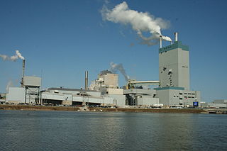
The Dryden pulp mill, also known as the Reed Mill, is a paper and pulp mill in Dryden, Ontario. During the 1960s and 70s, mercury poisoning from the mill caused one of Canada's worst environmental disasters: Dryden Chemicals Ltd dumped mercury into the English-Wabigoon River, upstream of Grassy Narrows First Nation, poisoning the fish which were their staple food. Members of the Grassy Narrows and the Whitedog communities downstream from the mill suffered severe mercury poisoning.

Seine River First Nation, previously known as the Rivière la Seine Band, is an Ojibwe First Nation reserve located roughly 300 kilometres (190 mi) west of Thunder Bay, Ontario. As of November 2011, the First Nation had a total registered population of 725, of which 327 lived on their own reserve.
Big Grassy First Nation is an Ojibwe or Ontario Saulteaux First Nation band government located in Rainy River District, Ontario near Morson, Ontario.
Ojibways of Onigaming First Nation is an Ojibwe or Ontario Saulteaux First Nation located in Kenora District, Ontario near Nestor Falls, Ontario. Together with the Big Grassy First Nation, Ojibways of Onigaming First Nation is a successor apparent to the former Assabaska Band of Saulteaux. Total registered population in February, 2012, was 737, of which the on-reserve population was 445. The First Nation is a member of the Anishinabeg of Kabapikotawangag Resource Council, a regional tribal council that is a member of the Grand Council of Treaty 3.
Assabaska is a Saulteaux First Nation reserve in northwestern Ontario on Lake of the Woods. It is shared between the Big Grassy First Nation and the Ojibways of Onigaming First Nation.
Mercury contamination in Grassy Narrows was an uncontrolled discharge of between 9,000 kilograms (20,000 lb) and 11,000 kilograms (24,000 lb) of mercury from the Dryden Mill's chloralkali plant in Dryden into the headwaters of the Wabigoon River in the Kenora District of Northwestern Ontario from 1962 until 1970. It was described as "one of the worst cases of environmental poisoning in Canadian history." The contamination poisoned many people in the Grassy Narrows First Nation and Whitedog First Nation communities.

