
The Lower Mainland is a geographic and cultural region of the mainland coast of British Columbia that generally comprises the regional districts of Metro Vancouver and the Fraser Valley. Home to approximately 3.05 million people as of the 2021 Canadian census, the Lower Mainland contains sixteen of the province's 30 most populous municipalities and approximately 60% of the province's total population.

The contiguous United States consists of the 48 adjoining U.S. states and the District of Columbia of the United States of America in central North America. The term excludes the only two non-contiguous states, which are Alaska and Hawaii, and all other offshore insular areas, such as the U.S. territories of American Samoa, Guam, the Northern Mariana Islands, Puerto Rico, and the U.S. Virgin Islands. The colloquial term "Lower 48" is also used, especially in relation to Alaska.

Campobello Island is the largest and only inhabited island in Campobello, a geographic parish in southwestern New Brunswick, Canada, near the border with Maine, United States. The island's permanent population in 2021 was 949. It is the site of the Roosevelt Campobello International Park, Head Harbour Lighthouse, and of Herring Cove Provincial Park.

The Gulf Islands is a group of islands in the Salish Sea between Vancouver Island and the mainland coast of British Columbia.

Manitoulin District is a district in Northeastern Ontario within the Canadian province of Ontario. It was created in 1888 from part of the Algoma District. The district seat is in Gore Bay.
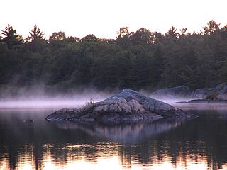
The Archipelago is a township in central Ontario, Canada, along the Georgian Bay in the Parry Sound District.
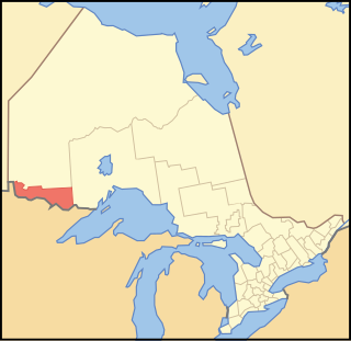
Rainy River District is a district and census division in Northwestern Ontario in the Canadian province of Ontario. It was created in 1885. It is the only division in Ontario that lies completely in the Central Time Zone, except for the township of Atikokan observing Eastern Standard Time for part of the year. Its seat is Fort Frances. It is known for its fishing and its location on the US border opposite International Falls, Minnesota, and Baudette, Minnesota.

Les Îles-de-la-Madeleine is a municipality located in Gaspésie-Îles-de-la-Madeleine region, in Quebec, Canada. The islands of the archipelago and the municipality are geographical and political versions of the same entity.

Loyalist is a lower-tier township municipality in central eastern Ontario, Canada on Lake Ontario. It is in Lennox and Addington County and consists of two parts: the mainland and Amherst Island. It was named for the United Empire Loyalists, who settled in the area after the American Revolution.
Deer Island is one of the Fundy Islands in the Bay of Fundy, Canada. It is at the entrance to Passamaquoddy Bay. The island was first settled by colonists around 1770.

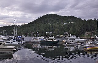
Powell River is a city on the northern Sunshine Coast of southwestern British Columbia, Canada. Most of its population lives near the eastern shores of Malaspina Strait, which is part of the larger Georgia Strait between Vancouver Island and the Mainland. With two intervening long, steep-sided fjords inhibiting the construction of a contiguous road connection with Vancouver to the south, geographical surroundings explain Powell River's remoteness as a community, despite relative proximity to Vancouver and other populous areas of the BC Coast. The city is the location of the head office of the qathet Regional District.
The Sunshine Coast is a geographic subregion of the British Columbia Coast that generally comprises the regional districts of qathet and Sunshine Coast.

The Chippewas of Georgina Island First Nation are an Ojibwa people located on Georgina Island in Lake Simcoe, Ontario, Canada. In 2008, of the First Nation's registered population of 666 people, 181 lived on, and 485 lived outside, their reserve. As of 2020, the band has a total population of 923 members. They are one of a handful of First Nations in the Toronto Census Metropolitan Area.
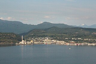
The qathet Regional District is a regional district in the Canadian province of British Columbia. Its only incorporated municipality is the City of Powell River, although it includes a number of unincorporated areas. The district encompasses a land area of 5,075.33 square kilometres (1,959.60 sq mi). The district was formerly known as the Powell River Regional District. Because of frequent confusion between the identical names of Powell River district and city, the district's name was changed in 2018 to qathet, from q̓at̓ᶿət, meaning "working together, bringing together" in the Comox language of the Tla'amin Nation.

Lot 35 is a township in Queens County, Prince Edward Island, Canada. It is part of Bedford Parish. It is split in two by the Hillsborough River. Lot 35 was awarded to Sir Alexander Maitland, 1st Baronet in the 1767 land lottery. It may have been sold to John MacDonald of Glenaladale in 1771, but Maitland was still listed as the proprietor after 1775. John MacDonald brought 210 Catholic Scottish Highlander settlers, 100 from Uist and 110 from mainland Scotland, to the "Tracadie Estate," which was composed of Lots 35 and 36. Lot 35 was sold for arrears in 1781 before being restored in 1791. It was sold in 1792 to John MacDonald of Glenaladale. It was one of the principal areas of Scottish settlement on the island by the census of April 1798. The Tenant League, formed in 1863, was active in Lot 35.

Nunavut is the largest and northernmost territory of Canada. It was separated officially from the Northwest Territories on April 1, 1999, via the Nunavut Act and the Nunavut Land Claims Agreement Act, which provided this territory to the Inuit for independent government. The boundaries had been drawn in 1993. The creation of Nunavut resulted in the first major change to Canada's political map in half a century since the province of Newfoundland was admitted in 1949.

Burnt Islands is a small coastal community found in God Bay on the southwest coast of Newfoundland, Canada.

Lake of the Woods is a township in the Canadian province of Ontario, located within the Rainy River District. The township is located on the eponymous Lake of the Woods, consisting of mainland in the south-east part of the lake, the southern shores of Aulneau Peninsula, along with several islands in the lake, including Big Island and Bigsby Island. It fully surrounds the Anishnaabeg of Naongashiing, Big Grassy River 35G, Big Island Mainland 93, and Saug-a-Gaw-Sing 1 First Nation reserves.
The Anishnaabeg of Naongashiing is a First Nation band government in Ontario. They are a member of the Anishinabeg of Kabapikotawangag Resource Council, which is a part of the Grand Council of Treaty 3. Their reserves include:

