Wawa, Ontario

Last updated

Wawa
Municipality of Wawa
Wawa ON 1.jpg
Wawa as seen across Wawa Lake
Canada Ontario location map 2.svg
Red pog.svg
Wawa
Coordinates: 47°59′35″N84°46′25″W / 47.99306°N 84.77361°W / 47.99306; -84.77361
Country Canada
Province Ontario
District Algoma
Established1899
Government
  MayorMelanie Pilon
  Federal riding Algoma—Manitoulin—Kapuskasing
  Prov. riding Algoma—Manitoulin
Area
[1]
  Land416.21 km2 (160.70 sq mi)
Elevation
[2]
287 m (942 ft)
Population
 (2021) [3]
  Total2,705
  Density7.0/km2 (18/sq mi)
Time zone UTC-5 (Eastern Standard Time (EST))
  Summer (DST) UTC-4 (Eastern Daylight Time (EDT))
Postal Code
P0S 1K0
Area code 705
Website www.wawa.cc OOjs UI icon edit-ltr-progressive.svg

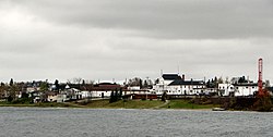
Wawa is a township in the Canadian province of Ontario in the Algoma District. Formerly known as the Township of Michipicoten, named after a nearby river of that name, the township was officially renamed in 2007 for its largest and best-known community of Wawa, located on the western shores of Wawa Lake. [4]

Contents

This area was first developed for fur trading. In the late 19th century, both gold and iron ore were found and mined, leading to the region's rise as the steel industry developed in Sault Ste. Marie, Ontario. From 1900 to 1918 the Helen Mine had the highest production of iron ore of any mine in Canada.

History

Fur trade days

Fort Michipicoten was constructed at the mouth of the Michipicoten River. It was at the junction of the main fur trade route from Montreal westward and the route to James Bay via the Missinaibi River. [5]

French explorers reached the area by the mid 17th century, and a post was built early in the next century. [6] The site was on the south bank of the river, opposite the mouth of the Magpie River. By 1729, it was an outpost of Fort Kaministiquia under command of Vérendrye's Postes du Nord. When the British conquered Canada in 1763, this post was abandoned. [5] [7]

Four years later, it was re-opened on the same site by fur traders Alexander Henry the elder and Jean Baptiste Cadotte. The route from James Bay was explored by Edward Jarvis (1775) and Philip Turnor (1781). In 1783, it was taken over by the North West Company, based in Montreal. [7] In 1797, the Hudson's Bay Company built a rival post on the north bank.

Michipicoten, 1897 Michipicoten, Ontario (1897).jpg
Michipicoten, 1897

With the union of the two companies in 1821, the Lake Superior trade was diverted from Montreal to Hudson Bay via Michipicoten. From 1827, the fort was the headquarters of the Superior Division, and several annual meetings were held here. It was a centre for fishing, boatbuilding and small-scale manufacture and repair. It also served as a base for missionaries and surveyors. This lasted until 1863, when the arrival of steamboats and railways made it unnecessary. It was closed in 1904 and gradually taken apart. [5] [7] In 1982, the site became the Michipicoten Provincial Park. [8]

Modern

Mining attempts began as early as the late 1660s.

William Teddy discovered gold on Wawa Lake in 1897. The population of Wawa village quickly grew with 1,700 claims staked in 1898. However, most gold production stopped by 1906. Beginning in 1914 with the completion of the Algoma Central Railway, gold production commenced again from 22 prospects. [9]

In 1898, the town site at what is now called "the Mission" was registered as "Michipicoten City." In 1899, Wawa was surveyed and plotted as a town and registered as Wawa City. In the latter half of the 1950s, the town's name was temporarily changed to Jamestown in honour of Sir James Hamet Dunn, but it was later returned to Wawa at the request of the community's residents.

Gold production had slowed by 1906, but as mining technology improved, additional amounts began to be extracted from the area. Gold mining in the Wawa area prospered and receded several times in the 20th century, and it continues today. Notable producers include the Grace Mine (1902-1944), which produced 15,191 ounces, the Minto Mine (1929-1942), which produced 37,678 ounces, the Parkhill Mine (1902-1944), which produced 54,301 ounces, and the Renabie Mine (1920-1991), which produced 1.1 million ounces. [9]

Iron ore extraction has also been an important industry in the area. The search for gold during the Michipicoten boom led to the unexpected discovery in 1897 of iron ore. Francis Hector Clergue, an American entrepreneur, immediately recognized the iron ore for its potential; he established a steel company at Sault Ste. Marie. Wawa was served by the Algoma Central Railway to ship ore for processing.

The first supply of ore extracted from the Helen Mine was shipped to Midland, Ontario, in July 1900; this was the "first boat shipment of Canadian iron ore to a Canadian port." The mine produced high-grade iron ore until 1903, when operations shut down due to financial difficulties encountered by Clergue and his company. By 1904, the mine had returned to full production capabilities and was mining one thousand tons of hematite ore a day. From 1900 to 1918, the Helen Mine had the largest production of any iron mine in Canada.

In 1909, a second hematite ore deposit was uncovered near the Magpie River, twelve miles north of the Helen Mine. The Algoma Steel Corporation, organized between 1904 and 1909 in Sault Ste. Marie, bought up the claims and operated both the Magpie and Helen mines for the next decade. The Helen Mine continued ore production until 1918, when the company felt the reserve of hematite ore was finally depleted. The same fate followed the Magpie Mine in 1921. The Census of Canada records that the population of the Michipicoten region in 1921 experienced a drop from 1,001 in 1911 to 101 just ten years later.

It was not until 1937, with the threat of war in Europe and the emergence of a profitable market for Canadian iron ore, that the Helen Mine was reopened. A sintering plant was constructed on the northern bank of the Magpie River, two miles west of the mine. It was used to treat the siderite ore before it was shipped to the blast furnaces at Algoma Steel in Sault Ste. Marie. The plant became the centre for a small community called Sinterville, composed of workers and their families.

The Helen Mine remained an open pit operation until 1950, from which point on all production came from underground mining. In 1960, the new George W. MacLeod Mine went into production adjacent to the Helen Mine. The ore was transported on an aerial tramline that consisted of over 280 steel three-ton buckets traveling underground and then emerging three-quarters of a mile west of the 2,066-foot vertical MacLeod Shaft. The tramline continued the remaining two miles to the sinter plant on overhead cables. This system was replaced in 1979 by the latest in underground mining technology, the highest-lift single-drive conveyor in the world.

During the summer of 1971, Wawa hosted an archaeological field camp known as the Wawa Drop-In Project or the Big Dig, [10] for young hitchhikers traveling along Highway 17. The project was directed by Professor K.C.A. Dawson [11] and supported by the federal government as part of its youth employment program. The results of this fieldwork at several important sites were never published. The records are currently held by the Canadian Museum of Civilization in Ottawa. [12]

Throughout the 1990s, Wawa and the Algoma Ore Division continued to be challenged by international market problems that plagued both the gold and iron mining industries. In December 1997, Algoma Steel announced that it could no longer support the high cost of extracting low-grade iron at Algoma Ore Division. Although Wawa's mountain of iron ore had more to give, operations were shut down in June 1998, one hundred years after iron was first discovered in this remote corner of northern Algoma.

Wawa suffered a population decline after the closures of Helen Mine and the sinter plant. Its main industries have been forestry and tourism. In recent years, diamond prospecting and proposals to create a trap rock mine on the shore of Lake Superior have been developed; however, no mining activities of any kind have yet been established.

In October 2007 Weyerhauser, which operated an oriented strandboard mill 30 kilometres east of the town, announced an indefinite shutdown of its mill. The final production shift ran at the end of December 2007. Given low demand for wood products, the likelihood of the mill reopening was marginal at best. Since the shutdown, Wawa's economy has suffered a near complete collapse, as the closure resulted in over 135 lost jobs, and more residents left the area. This has had a spinoff effect on other businesses and on the town's population. It peaked at close to 5,600 in the 1990s but has since dropped to under 3,000, according to the 2011 Canadian census.

The collapse of the forestry industry in the first decade of the 2000s also adversely affected the neighbouring communities of Dubreuilville and White River. Wawa, the area's largest settlement, has faced difficulties in attracting new industry to the community and region.

Geography

Community of Michipicoten River Michipicoten Rvr Vlg.jpg
Community of Michipicoten River

The township includes the main population centre of Wawa, as well as the smaller communities of Michipicoten and Michipicoten River, which are small coastal settlements on the shore of Lake Superior. These names are derived from the Ojibwe term for the river.

Climate

Wawa has a humid continental climate (Köppen climate classification Dfb) that is significantly moderated by Lake Superior. Winters are cold and snowy with a January high of −7.7 °C (18.1 °F) and a low of −20.2 °C (−4.4 °F) and temperatures below −20 °C (−4.0 °F) occur 45 days per year. [2] Snowfall totals are heavy, averaging over 319 centimetres (126 in) due to lake effect snow from Lake Superior as cold air from the northwest passes over the warmer lake. [13] Summers are cool and mild due to cool, dry air masses from the northwest and the cooling of warm air from the south as it passes Lake Superior. [13] [14] As a result, temperatures above 30 °C (86.0 °F) are rare. [2] August is the warmest month with a high of 20.8 °C (69.4 °F) and a low of 9.8 °C (49.6 °F), showing a slight seasonal lag. The average annual precipitation is 970 millimetres (38 in), which is relatively evenly distributed throughout the year though the months of July to October see a peak in precipitation. [2]

Climate data for Wawa Airport (1981−2010)
MonthJanFebMarAprMayJunJulAugSepOctNovDecYear
Record high humidex 6.712.320.130.637.139.037.138.934.928.319.718.539.0
Record high °C (°F)6.8
(44.2)
11.5
(52.7)
20.0
(68.0)
30.3
(86.5)
31.4
(88.5)
30.7
(87.3)
33.1
(91.6)
34.1
(93.4)
28.9
(84.0)
28.0
(82.4)
19.4
(66.9)
15.5
(59.9)
34.1
(93.4)
Mean daily maximum °C (°F)−7.7
(18.1)
−5.4
(22.3)
−0.2
(31.6)
7.5
(45.5)
14.6
(58.3)
19.0
(66.2)
20.9
(69.6)
20.8
(69.4)
16.6
(61.9)
9.5
(49.1)
2.2
(36.0)
−4.5
(23.9)
7.8
(46.0)
Daily mean °C (°F)−14.0
(6.8)
−11.9
(10.6)
−6.5
(20.3)
1.6
(34.9)
8.1
(46.6)
12.6
(54.7)
15.1
(59.2)
15.3
(59.5)
11.4
(52.5)
5.0
(41.0)
−1.8
(28.8)
−9.5
(14.9)
2.1
(35.8)
Mean daily minimum °C (°F)−20.2
(−4.4)
−18.3
(−0.9)
−12.8
(9.0)
−4.2
(24.4)
1.5
(34.7)
6.1
(43.0)
9.2
(48.6)
9.8
(49.6)
6.1
(43.0)
0.4
(32.7)
−5.7
(21.7)
−14.5
(5.9)
−3.6
(25.5)
Record low °C (°F)−40.9
(−41.6)
−50.0
(−58.0)
−37.1
(−34.8)
−25.2
(−13.4)
−9.4
(15.1)
−3.4
(25.9)
0.0
(32.0)
0.7
(33.3)
−5.2
(22.6)
−13.0
(8.6)
−26.0
(−14.8)
−39.0
(−38.2)
−50.0
(−58.0)
Record low wind chill −51.1−44.6−43.6−30.1−12.4−2.80.00.0−6.9−13.1−31.9−46.1−51.1
Average precipitation mm (inches)55.7
(2.19)
46.9
(1.85)
54.1
(2.13)
66.9
(2.63)
77.5
(3.05)
82.2
(3.24)
96.1
(3.78)
92.5
(3.64)
122.0
(4.80)
117.5
(4.63)
85.7
(3.37)
72.5
(2.85)
969.7
(38.18)
Average rainfall mm (inches)2.3
(0.09)
5.3
(0.21)
18.8
(0.74)
47.0
(1.85)
74.6
(2.94)
82.2
(3.24)
96.1
(3.78)
92.5
(3.64)
121.8
(4.80)
107.0
(4.21)
48.3
(1.90)
12.0
(0.47)
707.8
(27.87)
Average snowfall cm (inches)72.1
(28.4)
55.8
(22.0)
40.1
(15.8)
18.4
(7.2)
2.8
(1.1)
0.0
(0.0)
0.0
(0.0)
0.0
(0.0)
0.15
(0.06)
9.7
(3.8)
40.5
(15.9)
79.8
(31.4)
319.4
(125.7)
Average precipitation days (≥ 0.2 mm)17.014.111.910.512.412.813.213.315.315.616.117.6169.8
Average rainy days (≥ 0.2 mm)1.41.23.67.012.012.813.213.315.213.87.72.9104.2
Average snowy days (≥ 0.2 cm)16.714.09.65.10.830.00.00.00.233.311.216.777.7
Source: Environment Canada [2]

Demographics

In the 2021 Census of Population conducted by Statistics Canada, Wawa had a population of 2,705 living in 1,213 of its 1,377 total private dwellings, a change of -6.9% from its 2016 population of 2,905. With a land area of 411.89 km2 (159.03 sq mi), it had a population density of 6.6/km2 (17.0/sq mi) in 2021. [15]

Canada census – Wawa, Ontario community profile
2016 2011
Population2,905 (-2.4% from 2011)2,975 (-7.1% from 2006)
Land area416.21 km2 (160.70 sq mi)417.78 km2 (161.31 sq mi)
Population density7.0/km2 (18/sq mi)7.1/km2 (18/sq mi)
Median age46.6 (M: 45.9, F: 47.7)44.1 (M: 43.6, F: 44.8)
Private dwellings1,451 (total) 1,517 (total) 
Median household income$66,752$53,354
Notes: "Michipicoten Community Profile" prior to 2009.
References: 2016 [16] 2011 [17] earlier [18] [19]
Historical census populations – Wawa, Ontario
YearPop.±%
1976 4,940    
1981 4,743−4.0%
1986 4,481−5.5%
1991 4,154−7.3%
1996 4,145−0.2%
YearPop.±%
2001 3,668−11.5%
2006 3,204−12.6%
2011 2,977−7.1%
2016 2,905−2.4%
2021 2,705−6.9%
[20] [21] [1]
Source: Statistics Canada

Tourism and attractions

Goose sculpture in Wawa overlooking Highway 17 Canada Goose at Wawa Ontario.jpg
Goose sculpture in Wawa overlooking Highway 17

The community is known for its 8.5-metre (28-foot) metal statue of a Canada goose, which was built in 1960, and dedicated to the community in 1961. Wawa takes its name from the Ojibwe word for "wild goose", wewe. Wawa was defined as wild goose in The Song of Hiawatha. On July 5, 2010, Canada Post made a commemorative stamp of the Wawa Goose as part of its Roadside Attractions collection. [22] On July 1, 2017, a new Wawa Goose was unveiled to replace the second aging goose. [23]

The town is also known for snowmobiling and sport fishing. The Voyageur Hiking Trail passes through the town. One notable shopping location is Young's General Store, home of the locally famous Pickle Barrel.

Politics

The municipal council is composed of one mayor and four councillors. The current mayor is Melanie Pilon. Councillors Cathy Cannon, Micheline Hatfield, Joseph Opato and Jim Hoffmann were elected on October 24, 2022, for a four-year term.[ citation needed ]

Transportation

Highway 17, the main route of the Trans-Canada Highway, passes through the township, although the primary townsite is located on Highway 101, two kilometers east of the junction with Highway 17. Sault Ste. Marie is located 227 kilometers to the south. Lake Superior Provincial Park is located just south of the town.

In October 2012, the town was forced to declare a state of emergency after severe flooding washed out several roads within the municipality, including sections of both Highway 17 and Highway 101. [24]

Wawa is located 24 kilometres west of Canadian National Railway's Hawk Junction station on the rail line from Sault Ste. Marie to Hearst. The line, formerly known as the Algoma Central Railway, provides tourist operations, as well as passenger and freight service to communities in northern Ontario.

A dial-in/demand response transit system has been available since February 2006. The service is provided by a single bus that can accommodate 12 passengers plus up to two wheelchairs. [25]

Wawa has Ontario Northland motor coach service on its Sault Ste. MarieThunder Bay route. [26]

Education

Wawa is home to English and French language schools. The Algoma District School Board is responsible for offering English language instruction and operates Sir James Dunn Public School, offering kindergarten to Grade 8 classes, while Michipicoten High School offers Grades 9 to 12. The Huron-Superior Catholic District School Board provides French immersion language instruction for junior kindergarten to Grade 7 at St. Joseph French Immersion School. In the 2014–2015 school year St. Joseph School will expand its French immersion program to include Grade 8.

Exclusive French-language instruction is offered by two school boards. According to the 2011 Census, 19% of Wawa's population claimed French as their mother tongue. The Conseil scolaire du Grand Nord offers public school instruction at École publique l'Escalade for students in kindergarten to Grade 8. The Conseil scolaire catholique du Nouvel-Ontario offers Catholic instruction at École élémentaire et secondaire catholique St-Joseph.

Notable people

Wawa is home to former NHL hockey players Chris Simon and Denny Lambert as well as comedian Pete Zedlacher. [27]

See also

Related Research Articles

<span class="mw-page-title-main">Elliot Lake</span> City in Ontario, Canada

Elliot Lake is a city in Algoma District, Ontario, Canada. It is north of Lake Huron, midway between the cities of Sudbury and Sault Ste. Marie in the Northern Ontario region. Once dubbed the "uranium capital of the world," Elliot Lake has since diversified to a hub for advanced manufacturing, forest harvesting, mine reclamation expertise, retirement living, all-season tourism and remote work.

<span class="mw-page-title-main">Northern Ontario</span> Primary Region in Ontario, Canada

Northern Ontario is a primary geographic and quasi-administrative region of the Canadian province of Ontario, the other primary region being Southern Ontario. Most of the core geographic region is located on part of the Superior Geological Province of the Canadian Shield, a vast rocky plateau located mainly north of Lake Huron, the French River, Lake Nipissing, and the Mattawa River. The statistical region extends south of the Mattawa River to include all of the District of Nipissing. The southern section of this district lies on part of the Grenville Geological Province of the Shield which occupies the transitional area between Northern and Southern Ontario. The extended federal and provincial quasi-administrative regions of Northern Ontario have their own boundaries even further south in the transitional area that vary according to their respective government policies and requirements. Ontario government departments and agencies such as the Growth Plan for Northern Ontario and the Northern Ontario Heritage Fund Corporation define Northern Ontario as all areas north of, and including, the districts of Parry Sound and Nipissing for political purposes, and the federal but not the provincial government also includes the district of Muskoka.

<span class="mw-page-title-main">Algoma District</span> District in Ontario, Canada

Algoma District is a district and census division in Northeastern Ontario in the Canadian province of Ontario.

<span class="mw-page-title-main">Michipicoten River</span> River in Canada

The Michipicoten River is a river in Algoma District of northern Ontario, Canada, which flows from Dog Lake and joins with the Magpie River to empty into Michipicoten Bay on Lake Superior near the town of Wawa. This river is 113 km (70 mi) in length and drains an area of about 5,200 km2 (2,000 sq mi).

<span class="mw-page-title-main">Algoma—Manitoulin—Kapuskasing (federal electoral district)</span> Federal electoral district in Ontario, Canada

Algoma—Manitoulin—Kapuskasing is a federal electoral district in Ontario, Canada, that has been represented in the House of Commons of Canada since 2004. The area was represented by the riding of Algoma from 1867 to 1904 and from 1968 to 1996 and then by Algoma—Manitoulin from 1996 to 2004.

<span class="mw-page-title-main">Blind River, Ontario</span> Town in Ontario, Canada

Blind River is a town situated on the North Channel of Lake Huron in the Algoma District, Ontario, Canada. The town, named after the nearby Blind River, celebrated its centennial in 2006.

<span class="mw-page-title-main">Francis Clergue</span> American businessman

Francis Hector Clergue was an American businessman who became the leading industrialist of Sault Ste. Marie, Ontario, Canada, at the turn of the 20th century.

<span class="mw-page-title-main">Algoma Central Railway</span> Canadian train company

The Algoma Central Railway is a railway in Northern Ontario, Canada, that operates between Sault Ste. Marie and Hearst. It used to have a branch line to Wawa. The area served by the railway is sparsely populated, with few roads.

<span class="mw-page-title-main">Marathon, Ontario</span> Town in Ontario, Canada

Marathon is a town in the Canadian province of Ontario, located in Thunder Bay District, on the north shore of Lake Superior north of Pukaskwa National Park.

<span class="mw-page-title-main">Prince, Ontario</span> Township in Ontario, Canada

Prince is a township in the Canadian province of Ontario, located within the Algoma District northwest of Sault Ste. Marie. Although the township is not part of the city of Sault Ste. Marie, some municipal services are contracted to the city.

<span class="mw-page-title-main">Magpie River (Ontario)</span> River in Ontario, Canada

The Magpie River is a river in Algoma District, northeastern Ontario, Canada, The river empties into Michipicoten Bay on Lake Superior near the town of Wawa. The river drains an area of about 1,900 square kilometres (734 sq mi).

<span class="mw-page-title-main">Sault Ste. Marie (federal electoral district)</span> Federal electoral district in Ontario, Canada

Sault Ste. Marie is a federal electoral district in Ontario, Canada, that has been represented in the House of Commons of Canada since 1968.

<span class="mw-page-title-main">Unorganized North Algoma District</span> Unorganized area in Ontario, Canada

Unorganized North Algoma District is an unorganized area in northeastern Ontario, Canada, comprising all areas in Algoma District, north of the Sault Ste. Marie to Elliot Lake corridor, which are not part of an incorporated municipality or a First Nation. It covers 44,077.03 km2 (17,018.24 sq mi) of land, and had a population of 6050 in 2021. Many of these communities were/are stations on the Algoma Central Railway or were logging/mining towns.

<span class="mw-page-title-main">Huron Central Railway</span> Railway in Ontario, Canada

The Huron Central Railway is a railway operating in northern Ontario, Canada. It is operated by Genesee & Wyoming Canada, the Canadian subsidiary of Genesee & Wyoming.

<span class="mw-page-title-main">Michipicoten Island</span> Canadian island in Lake Superior

Michipicoten Island is an island in Ontario, Canada, in the northeastern part of Lake Superior, about 175 kilometres (109 mi) northwest of Sault Ste. Marie and 65 kilometres (40 mi) southwest of Wawa, Ontario. At its closest point to mainland Ontario, the island is located about 16 kilometres (9.9 mi) from the mainland. It falls within the boundaries of Thunder Bay District. The third largest island in Lake Superior, after Isle Royale and St. Ignace Island, Michipicoten Island is 27 kilometres (17 mi) long and 10 kilometres (6.2 mi) wide at its widest point.

Summit Lake is a lake in the Magpie River system in Unorganized North Part of Algoma District, Ontario, Canada in the Lake Superior drainage basin. It is about 0.6 kilometres (0.4 mi) long and 0.2 kilometres (0.1 mi) wide, lies at an elevation of 376 metres (1,234 ft). There are no significant inflows, and the primary outflow is an unnamed creek to Bog Lake, which eventually flows via Josephine Creek and the Magpie River into Lake Superior. The lake is about 5 kilometres (3 mi) northwest of the community of Hawk Junction and 16 kilometres (10 mi) northeast of Wawa. The Algoma Central Railway branch line to Michipicoten makes a loop, between Hawk Junction and Magpie, south of the lake.

<span class="mw-page-title-main">Sault Ste. Marie, Ontario</span> City in Ontario, Canada

Sault Ste. Marie is a city in Ontario, Canada. The third-largest city in Northern Ontario after Sudbury and Thunder Bay, it is located on the St. Mary's River on the Canada–US border. To the southwest, across the river, is the United States and the Michigan city of the same name. The two cities are joined by the Sault Ste. Marie International Bridge, which connects Interstate 75 on the Michigan side to Huron Street on the Ontario side. Shipping traffic in the Great Lakes system bypasses the Saint Mary's Rapids via the American Soo Locks, the world's busiest canal in terms of tonnage that passes through it, while smaller recreational and tour boats use the Canadian Sault Ste. Marie Canal.

The Mica Bay Incident was a land and resources dispute in along the shore of Lake Superior in November 1849. It is partially responsible for the signing of the 1850 Robinson-Huron Treaty.

<i>Michipicoten</i> (1952 ship) Self discharging lake freighter

Michipicoten is a self-discharging lake freighter owned and operated by Canadian shipping firm Lower Lakes Towing. Michipicoten primarily hauls taconite from Marquette, Michigan, to the Algoma Steel Mill in Sault Ste. Marie, Ontario. It has a capacity of 22,300 tons, a speed of 12 knots (14 mph), and a length of 689 feet 6 inches (210.2 m).

References

  1. 1 2 "Census Profile, 2016 Census: Wawa, Municipality". Statistics Canada. 8 February 2017. Retrieved June 9, 2019.
  2. 1 2 3 4 5 "Wawa Airport". Canadian Climate Normals 1981–2010. Environment Canada. Archived from the original on 2020-07-17. Retrieved December 17, 2013.
  3. "Profile table, Census Profile, 2021 Census of Population - Wawa, Municipality (MU) [Census Subdivision], Ontario". Statistics Canada. 9 February 2022. Retrieved 25 January 2023.
  4. "Annual changes to census subdivision codes, names and types, between 2006 and 2011, by province and territory, and by year". Standard Geographical Classification (SGC) 2011. Statistics Canada. 16 May 2011. Retrieved 2012-02-22.
  5. 1 2 3 Morton, Arthur Silver (1939). A history of the Canadian West to 1870-71 : being a history of Rupert's Land (the Hudson's Bay Company's territory) and of the North-west Territory (including the Pacific slope). Thomas Nelson & Sons Ltd. pp. 23, 39, 44, 158, 168. Retrieved 9 September 2021.
  6. "Fort Michipicoten". www.enhaut.ca. Voorhis Interactive: Posts of the Trade. Retrieved 9 September 2021.
  7. 1 2 3 Losey, Elizabeth Browne (1999). Let them be remembered: the story of the fur trade forts (1st ed.). New York: Vantage Press. ISBN   0533125723.
  8. "Michipicote". www.ontarioparks.com. Ontario Parks. Retrieved 8 September 2021.
  9. 1 2 Barnes, Michael (1995). Gold in Ontario. Erin: The Boston Mills Press. pp. 27–31. ISBN   155046146X.
  10. Special, 1971, June 29, "Small Time Mecca for Transient Youth", The Globe and Mail, p31
  11. "Prof. Kenneth (K. C. A.) Dawson, CD, MA". anthropology.lakeheadu.ca. Lakehead University. 2010-01-21. Retrieved 2011-08-25.
  12. "Catalogue Db query". catalogue.civilization.ca. Canadian Museum of Civilization.
  13. 1 2 "NATURAL PROCESSES IN THE GREAT LAKES". Us Environmental Protection Agency. 25 June 2012. Retrieved 30 September 2012.
  14. "Physical Geography of Ontario" (PDF). Archived from the original (PDF) on 17 December 2007. Retrieved 30 September 2012.
  15. "Population and dwelling counts: Canada, provinces and territories, census divisions and census subdivisions (municipalities), Ontario". Statistics Canada. February 9, 2022. Retrieved March 31, 2022.
  16. "2016 Community Profiles". 2016 Canadian Census . Statistics Canada. August 12, 2021. Retrieved 2019-06-09.
  17. "2011 Community Profiles". 2011 Canadian Census . Statistics Canada. March 21, 2019. Retrieved 2012-02-16.
  18. "2006 Community Profiles". 2006 Canadian Census . Statistics Canada. August 20, 2019.
  19. "2001 Community Profiles". 2001 Canadian Census . Statistics Canada. July 18, 2021.
  20. Statistics Canada: 1996, 2001, 2006 census.
  21. "Wawa census profile". 2011 Census of Population . Statistics Canada. Archived from the original on 2016-03-04. Retrieved 2012-02-16.
  22. Canada Post Stamp Details, July to September 2010, p 8, Volume XIX, No. 3
  23. "Wawa Goose is Unveiled!". Wawa News. Retrieved December 11, 2018.
  24. "Northern Ontario flooding may cause millions in damage". CTV News, October 27, 2012.
  25. "Transit Services". Municipality of Wawa. Archived from the original on 2 January 2019. Retrieved 11 December 2018.
  26. "Schedule 601-602 : Thunder Bay - Sault Ste. Marie" (PDF). Ontario Northland. March 19, 2023. Retrieved April 12, 2023.
  27. Wawa Boy Hits It Big Archived 2013-12-03 at the Wayback Machine . The Algoma News, October 4, 2010.