Trap rock

Last updated
The East Rock trap rock ridge overlooking New Haven, Connecticut, U.S. East Rock from SSS Hall, October 17, 2008.jpg
The East Rock trap rock ridge overlooking New Haven, Connecticut, U.S.
Trap rock forming a characteristic pavement, Giant's Causeway and Northern Ireland Causeway-code poet-4.jpg
Trap rock forming a characteristic pavement, Giant's Causeway and Northern Ireland
Trap rock cliff overlooking the Hudson River from an overlook on the Hudson Palisades in Bergen County, New Jersey, U.S. Palisades Sill near Englewood Cliffs.jpg
Trap rock cliff overlooking the Hudson River from an overlook on the Hudson Palisades in Bergen County, New Jersey, U.S.
Trap rock forming a characteristic stockade wall, Giant's Causeway, Northern Ireland Calzada de los gigantes01.jpg
Trap rock forming a characteristic stockade wall, Giant's Causeway, Northern Ireland

Trap rock, also known as either trapp or trap, is any dark-colored, fine-grained, non-granitic intrusive or extrusive igneous rock. Types of trap rock include basalt, peridotite, diabase, and gabbro. [1] Trap is also used to refer to flood (plateau) basalts, e.g. the Deccan Traps and Siberian Traps. [2] The erosion of trap rock created by the stacking of successive lava flows often created a distinct stairstep landscape from which the term trap was derived from the Swedish word trappa, which means "stairway". [1]

Contents

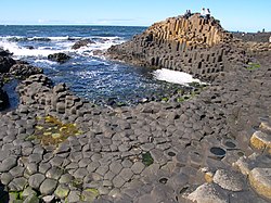
The slow cooling of magma either as a sill or as a thick lava flow sometimes creates systematic vertical fractures within the resulting layer of trap rock. These fractures often form rock columns that are typically hexagonal, but also four- to eight-sided. [3] [4]

Uses

Trap rock, i.e. basalt or diabase, has a variety of uses. A major use for basalt is crushed rock for road and housing construction in concrete, macadam, and paving stones. Because of its insensitivity to chemical influences, resistance to mechanical stress, high dry relative density, frost resistance, and sea water resistance, trap rock is used as ballast for railroad track bed and hydraulic engineering rock (riprap) in coast and bank protection for paving embankments. It is also used for the production of cast rock that is used in corrosion and abrasion protection, as for sewage pipes and acid-resistant rocks.

Other uses include gardening and landscaping, for the production of millstones, for the production of mineral fibres (basalt wool), as a flux in ceramic masses and glazes, for the production of glass ceramics, crushed as a filter aggregate (air filtration of poison gas) in ABC bunkers, as filter bed material water treatment facilities, and ground as a soil improvement product. [5] Trap rock has been used to construct buildings and churches: Trinity Church on the Green with trap rock quarried from Eli Whitney's quarry is a particularly colorful example of a red-orange-brown-colored, natural-faced trap rock.

Examples

Well-known examples of outcropping trap rock include both intrusive sills and extrusive lava flows. They include the Palisades Sill, a Triassic, 200 Ma diabase intrusion that forms the Palisades along 80 kilometers (50 mi) of the Hudson River in New York and New Jersey. Vast areas of trap rock in the form of thick lava flows and other volcanic rocks comprise the Deccan Traps of India and Siberian Traps of Russia. [6]

Other prominent basalt ridges, mountains, buttes, canyons, and other landscape features include:

See also

Related Research Articles

<span class="mw-page-title-main">Extrusive rock</span> Mode of igneous volcanic rock formation

Extrusive rock refers to the mode of igneous volcanic rock formation in which hot magma from inside the Earth flows out (extrudes) onto the surface as lava or explodes violently into the atmosphere to fall back as pyroclastics or tuff. In contrast, intrusive rock refers to rocks formed by magma which cools below the surface.

East Rock of south-central Connecticut, United States, with a high point of 366 feet (112 m), is a 1.4-mile (2 km) long trap rock ridge located primarily in the neighborhood of East Rock on the north side of the city of New Haven. A prominent landscape feature and a popular outdoor recreation area with cliffs that rise 300 feet (91 m) over the city below, East Rock is part of the narrow, linear Metacomet Ridge that extends from Long Island Sound near New Haven, north through the Connecticut River Valley of Massachusetts to the Vermont border. East Rock is the central feature of East Rock Park, a municipal park owned by the city of New Haven along the New Haven-Hamden town line.

<span class="mw-page-title-main">Watchung Mountains</span> Group of three long low ridges in northern New Jersey

The Watchung Mountains are a group of three long low ridges of volcanic origin, between 400 and 500 feet high, lying parallel to each other in northern New Jersey in the United States. The name is derived from the American Native Lenape name for them, Wach Unks. In the 18th century, the Euro-American settlers also called them the Blue Mountains or Blue Hills. The Watchung Mountains are known for their numerous scenic vistas overlooking the skylines of New York City and Newark, New Jersey, as well as their isolated ecosystems containing rare plants, endangered wildlife, rich minerals, and globally imperiled trap rock glade communities. The ridges traditionally contained the westward spread of urbanization, forming a significant geologic barrier beyond the piedmont west of the Hudson River; the town of Newark, for example, once included lands from the Hudson to the base of the mountains. Later treaties moved the boundary to the top of the mountain, to include the springs.

<span class="mw-page-title-main">Diabase</span> Type of igneous rock

Diabase, also called dolerite or microgabbro, is a mafic, holocrystalline, subvolcanic rock equivalent to volcanic basalt or plutonic gabbro. Diabase dikes and sills are typically shallow intrusive bodies and often exhibit fine-grained to aphanitic chilled margins which may contain tachylite.

<span class="mw-page-title-main">Flood basalt</span> Very large volume eruption of basalt lava

A flood basalt is the result of a giant volcanic eruption or series of eruptions that covers large stretches of land or the ocean floor with basalt lava. Many flood basalts have been attributed to the onset of a hotspot reaching the surface of the Earth via a mantle plume. Flood basalt provinces such as the Deccan Traps of India are often called traps, after the Swedish word trappa, due to the characteristic stairstep geomorphology of many associated landscapes.

<span class="mw-page-title-main">Intrusive rock</span> Magmatic rock formed below the surface

Intrusive rock is formed when magma penetrates existing rock, crystallizes, and solidifies underground to form intrusions, such as batholiths, dikes, sills, laccoliths, and volcanic necks.

<span class="mw-page-title-main">Hanging Hills</span> Hill range in Connecticut, US

The Hanging Hills of south central Connecticut, United States are a range of mountainous trap rock ridges overlooking the city of Meriden and the Quinnipiac River Valley 900 feet (274 m) below. They are a subrange of the narrow, linear Metacomet Ridge that extends from Long Island Sound near New Haven, Connecticut, north through the Connecticut River Valley of Massachusetts to the Vermont border. The range is also a subrange of the Appalachian Mountains. A popular outdoor recreation resource, the range is known for its microclimate ecosystems, rare plant communities, and expansive views from cliffs that rise abruptly over 700 feet (213 m) above the surrounding landscape. The Hanging Hills encompass the 1,800-acre (7.3 km2) Hubbard Park, designed with the help of landscape architect Frederick Law Olmsted. The 51 mile (80k) Metacomet Trail traverses the range.

<span class="mw-page-title-main">Palisades Sill</span>

The Palisades Sill is a Triassic, 200 Ma diabase intrusion. It extends through portions of New York and New Jersey. It is most noteworthy for The Palisades, the cliffs that rise steeply above the western bank of the Hudson River. The ideal location and accessibility of the sill, as well as its unique features, have generated much attention from nature enthusiasts, rock climbers, and geologists alike.

<span class="mw-page-title-main">Talcott Mountain</span> Mountain in Connecticut, USA

Talcott Mountain of central Connecticut, with a high point of 950 feet (290 m), is a 13-mile (21 km) long trap rock mountain ridge located 6 miles (10 km) west of the city of Hartford. The ridge, a prominent landscape feature, forms a continuous line of exposed western cliffs visible across the Farmington River valley from Farmington to Simsbury. Talcott Mountain is part of the narrow, linear Metacomet Ridge that extends from Long Island Sound near New Haven, Connecticut, north through the Connecticut River Valley of Massachusetts to the Vermont border.

<span class="mw-page-title-main">Mount Nonotuck</span>

Mount Nonotuck, 827 feet (252 m), is the northernmost peak of the Mount Tom Range of traprock mountains located in the Connecticut River Valley of Massachusetts and part of the larger Metacomet Ridge which stretches from Long Island Sound to nearly the Vermont border. Rugged and considered scenic, the peak rises steeply from the river valley 700 feet (210 m) below. It is located within the town of Holyoke.

<span class="mw-page-title-main">Provin Mountain</span>

Provin Mountain is a very narrow traprock mountain ridge located in the Connecticut River Valley of Massachusetts. It is part of the Metacomet Ridge which extends from Long Island Sound near New Haven, Connecticut, north through the Connecticut River Valley of Massachusetts to the Vermont border. Provin Mountain is known for its scenic cliffs, unique microclimate ecosystems, and rare plant communities. It is traversed by the 114 mile (183 km) Metacomet-Monadnock Trail.

<span class="mw-page-title-main">East Mountain (Massachusetts)</span>

East Mountain is a traprock mountain ridge located in the Connecticut River Valley of Massachusetts. It is part of the narrow, linear Metacomet Ridge that extends from Long Island Sound near New Haven, Connecticut, north through the Connecticut River Valley of Massachusetts to the Vermont border. East Mountain is known for its extensive scenic cliffs, unique microclimate ecosystems, and rare plant communities. It is traversed by the 110-mile (180 km) Metacomet-Monadnock Trail.

<span class="mw-page-title-main">Mount Norwottuck</span>

Mount Norwottuck or Mount Norwottock, 1,106 feet (337 m) above sea level, is the highest peak of the Holyoke Range of traprock mountains located in the Connecticut River Valley of Massachusetts and part of the greater Metacomet Ridge which stretches from Long Island Sound to nearly the Vermont border. The peak rises steeply from the valley 1,000 feet (300 m) below and offers sweeping views of the surrounding countryside. It is located within the towns of Amherst and Granby, Massachusetts.

<span class="mw-page-title-main">Trimountain</span> Mountain in the American state of Connecticut

Trimountain or Tri-mountain, est. 760 feet (230 m), is a traprock mountain located 6 miles (10 km) southeast of Meriden, Connecticut. It is part of the narrow, linear Metacomet Ridge that extends from Long Island Sound near New Haven, Connecticut, north through the Connecticut River Valley of Massachusetts to the Vermont border. Trimountain is known for its scenic cliff faces, unique microclimate ecosystems, and rare plant communities. The mountain is traversed by the 51-mile (82 km) Mattabesett Trail.

<span class="mw-page-title-main">Short Mountain (Connecticut)</span> Traprock ountain in the American state of Connecticut

Short Mountain is a traprock mountain located in south central Connecticut 5 miles (8 km) north of the city of Meriden. It is part of the narrow Metacomet Ridge that extends from Long Island Sound near New Haven, Connecticut, north through the Connecticut River Valley of Massachusetts to the Vermont border. Short Mountain is known for its scenic cliffs, unique microclimate ecosystems, and rare plant communities. It is traversed by the 51-mile (82 km) Metacomet Trail.

<span class="mw-page-title-main">Hatchett Hill</span> Traprock ridge in the American state of Connecticut

Hatchett Hill, est. 510 feet (160 m), is a trap rock ridge located in East Granby, Connecticut, 11 miles (18 km) northeast of Hartford, Connecticut. It is part of the narrow, linear Metacomet Ridge that extends from Long Island Sound near New Haven, Connecticut, north through the Connecticut River Valley of Massachusetts to the Vermont border. The southern edge of the ridge plunges nearly 200 vertical feet into the Tariffville Gorge. The ridge is known for its rugged topography, unique microclimate ecosystems, rare plant communities, and as a seasonal raptor migration path. It is traversed by the 51-mile (82 km) Metacomet Trail.

Peter's Rock, also known as Rabbit Rock, Rabbit Hill, Indian Rock and Great Rock, with a high point of (est.) 373 feet (114 m) above sea level, is a trap rock peak located 4 miles (6 km) northeast of downtown New Haven, Connecticut in the town of North Haven. It is part of the Metacomet Ridge that extends from Long Island Sound near New Haven, north through the Connecticut River Valley of Massachusetts to the Vermont border. Peter's Rock is known for its scenic views, unique microclimate ecosystems, rare plant communities, and columnar basalt rock formations. It is traversed by a number of hiking trails managed by the non-profit Peter's Rock Association.

<span class="mw-page-title-main">Long Mountain (Hampshire County, Massachusetts)</span>

Long Mountain, 920 feet (280 m) feet above sea level, is a traprock mountain of the Holyoke Range, part of the greater Metacomet Ridge which stretches from Long Island Sound to nearly the Vermont border. The mountain rises steeply from the surrounding landscape 600 feet (180 m) below and consists of five distinct peaks, from east to west: 685 feet (209 m), 775 feet (236 m), 795 feet (242 m), 920 feet (280 m), the high point, and the eastern summit, 906 feet (276 m). It is located within the towns of Amherst and Granby, Massachusetts. The 110-mile (180 km) Metacomet-Monadnock Trail and the 47-mile (76 km) Robert Frost Trail traverse the mountain. The Holyoke Range continues to the west as Mount Norwottuck and to the east as Harris Mountain.

<span class="mw-page-title-main">Igneous rock</span> Rock formed through the cooling and solidification of magma or lava

Igneous rock, or magmatic rock, is one of the three main rock types, the others being sedimentary and metamorphic. Igneous rocks are formed through the cooling and solidification of magma or lava.

The Watchung Outliers include six areas of isolated low hills and rock outcrops of volcanic and sedimentary origin in the U.S. states of New York, New Jersey, and Pennsylvania. These geologic outliers are primarily diminutive and detached remnants of the Triassic/Jurassic age Watchung Mountain basalt flows with intervening layers of sedimentary rock. All six of the outliers are found along the western edge of the Newark Basin, occupying small synclines adjacent to the Ramapo fault system. The outliers, from north to south, are known as: Ladentown, Union Hill, New Germantown/Oldwick, Prospect Hill, Sand Brook, and Jacksonwald.

References

  1. 1 2 Neuendorf, K.K.E., J.P. Mehl, Jr., and J.A. Jackson, J.A., eds. (2005) Glossary of Geology (5th ed.) American Geological Institute, Alexandria, Virginia. 779 pp. ISBN   978-0-922152-76-6
  2. Le Maitre, R. W., ed. (2002) Igneous Rocks: A Classification and Glossary of Terminology. Cambridge University Press, New York. 236 pp. ISBN   978-0-521-66215-4
  3. Muller, G. (1998) "Experimental simulation of basalt columns". Journal of Volcanology and Geothermal Research. vol. 86, no. 1–4, pp. 93–96
  4. Spry, A. (1962). "The origin of columnar jointing, particularly in basalt flows". Journal of the Geological Society of Australia. Vol. 5, pp. 191–216.
  5. Lorenz, W., and W. Gwosdz (2003). Manual on the Geological-technical Assessment of Mineral Construction Materials. Geological Yearbook Special Issue series H, issue SH15. Federal Institute for Geosciences and Natural Resources and the State geological surveys in the Federal Republic of Germany, Commission E. Hense (Naegele and Obermiller), Hanover, Germany. 497 pp. ISBN   3-510-95917-5.
  6. Sheth, Hetu C. "Deccan Traps". www.mantleplumes.org. Retrieved 2022-11-21.
  7. Olsen, Paul E.; McDonald, Nicholas G.; Huber, Phillip; Cornet, Bruce (October 9–11, 1992). "Stratigraphy and Paleoecology of the Deerfield Rift Basin (Triassic-Jurassic, Newark Supergroup), Massachusetts". Guidebook for field trips in the Connecticut Valley region of Massachusetts and adjacent states. 84th annual meeting, New England Intercollegiate Geological Conference. www.sunstar-solutions.com. Vol. 2. The Five Colleges, Amherst, MA. pp. 488–535. Retrieved 2022-11-21.
  8. Farnsworth, Elizabeth J. (2004-07-17). "Metacomet-Mattabesett Trail Natural Resource Assessment" (PDF). Metacomet-Mattabesett Trail. Archived from the original on 2007-08-07. Retrieved 2022-11-21.{{cite web}}: CS1 maint: unfit URL (link)
  9. Raymo, Chet; Raymo, Maureen E. (1989). Written in stone : a geological and natural history of the northeastern United States. Maureen E. Raymo (1 ed.). Chester, Conn.: Globe Pequot Press. p. 24. ISBN   0-87106-680-7. OCLC   18072295.