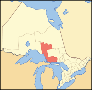
Algoma District is a district and census division in Northeastern Ontario in the Canadian province of Ontario.

The Batchawana River is a river in Algoma and Sudbury Districts of Ontario, Canada, which empties into Batchawana Bay on Lake Superior north of Sault Ste. Marie, Ontario.

The Goulais River is a river in northern Ontario, Canada, which rises in the Algoma highlands and empties into Goulais Bay on eastern Lake Superior near Sault Ste. Marie, Ontario. It is one of the largest tributaries on the eastern lake, draining an area of approximately 2,000 square kilometres (770 sq mi).

Sault Ste. Marie is a federal electoral district in Ontario, Canada, that has been represented in the House of Commons of Canada since 1968.

Unorganized North Algoma District is an unorganized area in northeastern Ontario, Canada, comprising all areas in Algoma District, north of the Sault Ste. Marie to Elliot Lake corridor, which are not part of an incorporated municipality or a First Nation. It covers 44,077.03 km2 (17,018.24 sq mi) of land, and had a population of 6050 in 2021. Many of these communities were/are stations on the Algoma Central Railway or were logging/mining towns.

Zhiibaahaasing First Nation is a First Nation band government in the Canadian province of Ontario. It is a member of the United Chiefs and Councils of Manitoulin.
The Robinson Treaties are two treaties signed between the Ojibwa chiefs and the Crown in 1850 in the Province of Canada. The first treaty involved Ojibwa chiefs along the north shore of Lake Superior, and is known as the Robinson Superior Treaty. The second treaty, signed two days later, included Ojibwa chiefs from along the eastern and northern shores of Lake Huron, and is known as the Robinson Huron Treaty. The Wiikwemkoong First Nation did not sign either treaty, and their land is considered "unceded".

Batchawana Bay is a small bay in Algoma District in Northeastern Ontario, Canada. It is on the eastern shore of Lake Superior, approximately 50 kilometres (31 mi) north of Sault Ste. Marie.

Rankin Location 15D is one of four reserves of the Batchewana First Nation in Algoma District in northeastern Ontario, Canada. It is bounded on the north, west and south by the city of Sault Ste. Marie, and on the east by Garden River First Nations reserve of another Ojibwe people. As of 2005, a total of 2,205 people were registered to the Nation; about half live on the reserves and many others live in Sault Ste. Marie.
Hay River Reserve is one of only three Indian reserves in Canada's Northwest Territories. Located in the South Slave Region, it is a Slavey community with a population of 259, of which the majority are First Nations and some Métis, at the 2021 Canadian census, a 16.2% decrease from the 2016 census. The main languages on the reserve are South Slavey, and English. In 2017 the Government of the Northwest Territories reported that the population was 329, resulting in an average annual growth rate of 0.4% between 2007 and 2017.

Apitipi Anicinapek Nation, formerly known as Wahgoshig First Nation, is an Algonquin Anicinape community, located near Matheson in Cochrane District in northeastern Ontario, Canada. In January 2008, the First Nation had 270 people registered with the nation, of which their on-reserve population was 121.

Rainbow Country is a local services board in the Canadian province of Ontario. It encompasses and provides services to the communities of Whitefish Falls and Willisville in the Unorganized North Sudbury District and Birch Island and McGregor Bay in the Manitoulin District.

Sault Ste. Marie is a city in Ontario, Canada. The third-largest city in Northern Ontario after Sudbury and Thunder Bay, it is located on the St. Mary's River on the Canada–US border. To the southwest, across the river, is the United States and the Michigan city of the same name. The two cities are joined by the Sault Ste. Marie International Bridge, which connects Interstate 75 on the Michigan side to Huron Street on the Ontario side. Shipping traffic in the Great Lakes system bypasses the Saint Mary's Rapids via the American Soo Locks, the world's busiest canal in terms of tonnage that passes through it, while smaller recreational and tour boats use the Canadian Sault Ste. Marie Canal.
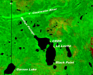
The Clearwater River Dene Nation is a Dene First Nations band government in the boreal forest area of northern Saskatchewan, Canada. It maintains offices in the village of Clearwater River situated on the eastern shore of Lac La Loche. The Clearwater River Dene Nation reserve of Clearwater River shares its southern border with the village of La Loche.
The Batchewana First Nation is an Ojibway First Nation in northern Ontario. Their traditional lands run along the eastern shore of Lake Superior, from Batchawana Bay to Whitefish Island. They were reserved this land in the 1850 Robinson Huron Treaty, but surrendered most of it under the 1859 Pennefather Treaty. Through purchase and land claims, it has reclaimed some territories, including Goulais Bay 15A, Obadjiwan 15E, Rankin Location 15D and Whitefish Island.
Obadjiwan 15E is a First Nations reserve in Algoma District, Ontario. It consists of two non-contiguous parcels of land on Batchewana Bay, and is one of the reserves of the Batchewana First Nation.
Goulais Bay 15C was a First Nation reserve within Prince Township, Ontario. This 5-acre tract of land was given to the Batchewana First Nation after Whitefish Island was expropriated from them in 1902. The land was sold by the band in 1956 for $3,600, and it ceased to be a reserve.

Goulais Bay is a bay of Ontario in Canada. It is part of Whitefish Bay which in turn is a large bay of Lake Superior. Goulais Point, on the southernmost tip of the peninsula that separates the bay from Batchawana Bay just to the north and from Whitefish Bay to the west, marks the northern entrance of Goulais Bay. North Gros Cap is the rock point that forms the bay's southern limit.
The Algoma Headwaters Provincial Park is a large provincial park in Algoma and Sudbury Districts, Ontario, Canada. It is undeveloped remote wilderness located about 90 kilometres (56 mi) northeast of Sault Ste. Marie, with little road access.

