The area which is now known as Hilton Beach had its origins in the 1850s when a wharf was first built. By the 1860s, fourteen families had settled in the area, including the Trainors, Rousseaus, Gordons, Bishops and Desjardins.[citation needed]
John Marks came to St. Joseph Island in the 1860s to settle at Sailors Encampment. He moved to the area that would become Hilton Beach in 1872. Marks first opened a store and a wood dock followed by a post office six years later under the name of Marksville. A school was established in 1877, and in 1881 St. John's Anglican Church was erected.[citation needed]
J. Archibald built a hotel in 1879, originally called The Ottawa House. It was moved to its current site in 1890. Other businesses included Bowker's General Store, Duncan's General Store, R. Chester's shoemaker shop, and the sawmill operated by Dean and Davis. J.C. Cooper was a wagon maker, and T. Steinburg was the blacksmith, who operated out of the white concrete building still standing today on Hilton Road.[citation needed]
A.G. Duncan, D. McPhail and John Marks were justices. The village was called Marksville until June 1, 1921, when it was changed to Hilton Beach.[citation needed] Two years later the village split off from Hilton Township and became a separate village municipality.[2]
Many of the historical buildings in Hilton Beach are still being used today. The community hall, renovated in 1989, was originally built in 1896 and used as a schoolhouse until the 1960s. The old town hall, built in 1916, was used as a violin workshop for several years and is now for sale. The Hilton Beach General Store is over 100 years old and is still open for business.[citation needed]
The Hilton Beach jail is unusual in that it never actually housed an inmate. The small building, barely measuring 20' by 20', in fact housed the Hilton Beach Library for several years in the 1920s. The library is now housed in another historical building on Marks Street.[citation needed]
Demographics
In the 2021 Census of Population conducted by Statistics Canada, Hilton Beach had a population of 198 living in 98 of its 134 total private dwellings, a change of 15.8% from its 2016 population of 171. With a land area of 2.52km2 (0.97sqmi), it had a population density of 78.6/km2 (203.5/sqmi) in 2021.[1]
The MS Norgoma, a package freighter and passenger ferry, called on Hilton Beach on Wednesdays until 1963.[citation needed]
Hilton Beach Marina
Today, the village attracts visitors primarily from Sault Ste. Marie and southern Ontario, as well as Michigan.[citation needed]
The village's location on Lake Huron makes it a very popular boating destination. The Hilton Beach Marina has over 180 slips (approximately one for every resident in the town) and is very popular in the summer. The excellent[according to whom?]sailing in the St. Joseph Channel is the main attraction for many seasonal residents and tourists. The marina operates from May through to October.[citation needed]
The Hilton Beach Tourist Park, a tent and trailer park, was built in the 1950s. The Park welcomes back dozens of seasonal residents every summer and is a community unto itself during peak season.[citation needed]
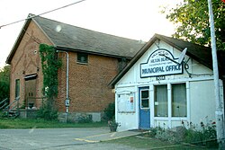
Government
The mayor of the village is Robert Hope, and its councillors are John Wells, Julie C. Moore, John Davison and Shirley Bailey Meeks. The village clerk is Peggy Cramp.[7]
This page is based on this Wikipedia article Text is available under the CC BY-SA 4.0 license; additional terms may apply. Images, videos and audio are available under their respective licenses.