The division includes the communities of Burnt Island, Cook's Dock, Fernlee, Meldrum Bay, and Silver Water.
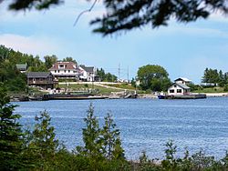
Meldrum Bay
Meldrum Bay (45°55′39″N83°06′53″W / 45.92750°N 83.11472°W / 45.92750; -83.11472)[6] is located at the western terminus of Highway 540, 72 kilometres (45mi) west of Gore Bay. Settled in the 1870s by Scottish people from southern Ontario, and named after the namesake bay on which it is located, Meldrum Bay developed as a commercial fishing and lumbering centre. Its first mill opened in 1880. Once the village was home to stores, hotels, blacksmiths, school, and boarding houses, as well as a busy fishing fleet and Great Lakes steamers tied up at the docks.[7]
Many residents of the area are employed by Lafarge, whose quarry west of Meldrum Bay produces dolomite used in concrete, road construction and metallurgical processing. This Lafarge Canada site opened in the 1980s and is the home of the "largest Canadian marine quarry," with loading docks on the Mississagi Strait.[8]
Silver Water
Silver Water (45°51′27″N82°51′26″W / 45.85750°N 82.85722°W / 45.85750; -82.85722)[9] is located on Highway 540 approximately 42 kilometres (26mi) west of Gore Bay. Named after, or around the same time as, nearby Silver Lake, it has a year-round population of approximately 62 families, which almost doubles during the summer months. It is a vibrant rural community, with the majority of the population being retired seniors. The community contains a well equipped community center as well as a popular country-style diner, both of which are well used community gathering sites. Silver Water has an all volunteer fire department, servicing the Robinson geographic township, consisting of 1 pumper and 2 tankers. This helps in keeping the residents homeowners insurance rates down. Silver Water also has a very active membership in the local United Church.
Demographics
Canada census – Manitoulin, Unorganized, West Part – community profile
This page is based on this Wikipedia article Text is available under the CC BY-SA 4.0 license; additional terms may apply. Images, videos and audio are available under their respective licenses.