
The Spanish River is a river in Algoma District, Sudbury District and Greater Sudbury in Northeastern Ontario, Canada. It flows 338 kilometres (210 mi) in a southerly direction from its headwaters at Spanish Lake and Duke Lake to its mouth at the North Channel of Lake Huron just outside the community of Spanish.

The Goulais River is a river in northern Ontario, Canada, which rises in the Algoma highlands and empties into Goulais Bay on eastern Lake Superior near Sault Ste. Marie, Ontario. It is one of the largest tributaries on the eastern lake, draining an area of approximately 2,000 square kilometres (770 sq mi).

The Amable du Fond River is a river in Nipissing District, in Northern Ontario, Canada.

Quetico Provincial Park is a large wilderness park in Northwestern Ontario, Canada, known for its excellent canoeing and fishing. The 4,760 km2 (1,180,000-acre) park shares its southern border with Minnesota's Boundary Waters Canoe Area Wilderness, which is part of the larger Superior National Forest. These large wilderness parks are often collectively referred to as the Boundary Waters or the Quetico-Superior Country.
Ontario Parks is a branch of the Ministry of the Environment, Conservation and Parks in Ontario, Canada, that protects significant natural and cultural resources in a system of parks and protected areas that is sustainable and provides opportunities for inspiration, enjoyment and education. The Ontario Parks system covers over 78,000 square kilometres (30,000 sq mi), which is about 10 per cent of the province's surface area or the equivalent of an area approximately equal to Nova Scotia. It falls under the responsibility and mandate of the province's Ministry of the Environment, Conservation and Parks. It was formerly under the mandate of the Ministry of Natural Resources and Forestry.
A provincial park is a park administered by one of the provinces of a country, as opposed to a national park. They are similar to state parks in other countries. They are typically open to the public for recreation. Their environment may be more or less strictly protected.

Sandbanks Provincial Park is a provincial park located on Lake Ontario in Prince Edward County near Picton, Ontario, Canada. The park is considered one of the best sandy beaches in Ontario and contains the largest bay-mouth barrier dune formation in the world. The 1,550.87-hectare (3,832.3-acre) park was established in 1970 and operates year round. Birdwatching, camping, cycling, fishing, and swimming are among the activities available in the park.
The Obabika River Provincial Park is a provincial park in Ontario, Canada, straddling across the boundaries of the Sudbury, Nipissing, and Timiskaming Districts. While it is named after and includes the Obabika River, the bulk of the park extends north of Obabika Lake to the eastern boundary of Lady Evelyn-Smoothwater Provincial Park.

The Queen Elizabeth II Wildlands Provincial Park is a provincial park in south-central Ontario, Canada, between Gravenhurst and Minden. The park, named for Elizabeth II, who at the time was Queen of Canada, is 33,505 hectares in size, making it the second largest park south of Algonquin Park, but it has a fragmented shape as a result of many private lands within its boundary.
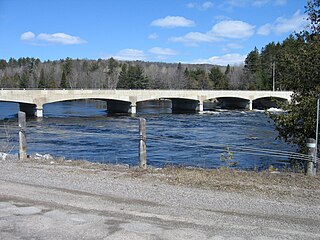
Lower Madawaska River Provincial Park is a waterway-class provincial park on the Madawaska River in Renfrew County, Ontario, Canada. The park includes the shores on both sides of the Madawaska River from Latchford Bridge to Griffith.
The Temagami River, formerly spelled as Timagami River, is a river in the Nipissing District of Ontario, Canada, in the Temagami region. Its source is Lake Temagami and flows through Cross Lake and Red Cedar Lake. It flows into the Sturgeon River at the community of River Valley.

The Sturgeon River Provincial Park is a provincial park in northern Ontario, Canada, that protects about 70 kilometres (43 mi) long section of the Sturgeon River and its banks, from Woods Lake to the Sudbury-Nipissing District boundary. It was established in 1989 and expanded in 2005. It protects outstanding water routes that provide recreational canoe camping opportunities. Other activities include hunting and fishing.

The Western Great Lakes forests is a terrestrial ecoregion as defined by the World Wildlife Fund. It is within the temperate broadleaf and mixed forests biome of North America. It is found in northern areas of the United States' states of Michigan, Wisconsin and Minnesota, and in southern areas of the Canadian province of Manitoba and northwestern areas of the province of Ontario.
Kap-Kig-Iwan Provincial Park is a protected area in the incorporated townships of Charlton and Dack and Evanturel in Timiskaming District in Northeastern Ontario, Canada. Established in 1957, the 325-hectare (803-acre) park is located along the Englehart River, off Ontario Highway 11 about 2 kilometres (1.2 mi) south of the town of Englehart. Kap-Kig-Iwan is classified as a Natural Environment park and is a provincial park of Ontario.
The Little White River is a river in the Unorganized North Part of Algoma District in Northeastern Ontario, Canada. It is in the Great Lakes Basin and is a left tributary of the Mississagi River.
The Makobe River is a river in northeastern Ontario, Canada. It is in the Saint Lawrence River drainage basin, and is a left tributary of the Montreal River.
The East English River Provincial Park is a linear waterway park in Kenora District, Ontario, Canada. It includes a 200 metres (660 ft) wide strip of land on both sides of the English River and its lakes, from the intersection of Highway 599 to Minnitaki Lake. It was established in 2003 to protect natural features, that are representative of the area, and high quality recreational canoe routes with over 30 sets of rapids. The park's notable features include white pine forest at the northern extent of its range, white elm and burr oak, caribou habitat and calving locations, fisheries, and archaeological sites.

The Kopka River is a river in northwestern Ontario, Canada. It forms at the height-of-land west of Lake Nipigon, flowing through rugged wilderness of Ontario's northern boreal forest, and drains into Wabinosh Lake.