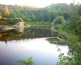
The York River is a river in Renfrew County, Hastings County and Haliburton County in Ontario, Canada. The river is in the Saint Lawrence River drainage basin, and flows from the southern extension of Algonquin Provincial Park to the Madawaska River.

The Sand River is a river in the Unorganized North Part of Algoma District in Northeastern Ontario, Canada. It is in the Great Lakes Basin, is a tributary of Lake Superior, and its entire course lies within Lake Superior Provincial Park.

Restoule Provincial Park is a provincial park in Parry Sound District in Central Ontario, Canada. It is located between Restoule Lake and Stormy Lake and extends along the banks of the Restoule River to its mouth at the French River in geographic Patterson Township and geographic Hardy Township. The park is located at the western terminus of Highway 534 northwest of Restoule, Ontario. The park offers three hiking trails and is home to coyotes, wolves, bears, otters, pine martens, moose and one of Ontario's largest white-tailed deer herds. It is also home to over 90 species of birds including the peregrine falcon and the heron. Camping areas include Bells Point, Putts Point and Kettle Point. Many hike the well-marked trail to the 100-foot (30 m) fire tower overlooking Stormy Lake. It is one of two provincial parks found in the Almaguin Highlands.
Évanturel is a township in Timiskaming District, Ontario, Canada. It almost completely surrounds the town of Englehart. The main settlement in Évanturel is the community of Heaslip.

The Englehart River is a river in Timiskaming District in northeastern Ontario, Canada. It is in the Saint Lawrence River drainage basin and is a right tributary of the Blanche River.

The Blanche River is a river in the Saint Lawrence River drainage basin in Timiskaming District in northeastern Ontario, Canada. The river is a tributary of Lake Timiskaming and its name is from the French for the colour "white".
The Carp River is a river in the Unorganized North Part of Algoma District in Northeastern Ontario, Canada. The river is in the Great Lakes Basin and is a tributary of Lake Superior.
Terry Township is an unincorporated geographic township in the Unorganized West part of Timiskaming District in Northeastern Ontario, Canada. The township lies on the northern edge of Timaskaming District on the border with Cochrane District.
Marter Township is an unincorporated geographic township in the Unorganized West part of Timiskaming District in Northeastern Ontario, Canada. The township is named for George Frederick Marter.
Sullivan Lake is a lake in geographic Ben Nevis Township, Cochrane District, with a small tip in geographic Katrine Township, Timiskaming District, in Northeastern Ontario, Canada. It is in the Saint Lawrence River drainage basin and is the source of the Misema River. The lake is also located in the Pushkin Hills, part of the Blake River Megacaldera Complex.
Fallduck Lakes is a lake in geographic Terry Township, Timiskaming District in Northeastern Ontario, Canada. It is in the Saint Lawrence River drainage basin and is the source of the Englehart River.
The Little White River is a river in the Unorganized North Part of Algoma District in Northeastern Ontario, Canada. It is in the Great Lakes Basin and is a left tributary of the Mississagi River.
The Matawin River is a river in Thunder Bay District in Northwestern Ontario, Canada. It is in the Great Lakes Basin and is a right tributary of the Kaministiquia River.
The Nemegosenda River is a river in Algoma District and Sudbury District in northeastern Ontario, Canada. It is in the James Bay drainage basin, and is a right tributary of the Kapuskasing River.
The Valentine River is a river in the Unorganized North Part of Cochrane District in northeastern Ontario, Canada. It is in the Moose River drainage basin, and is a tributary of Lac Pivabiska, the source of the Pivabiska River.
The Little Valentine River is a river in the Unorganized North Part of Cochrane District in northeastern Ontario, Canada. It is in the Moose River drainage basin, and is a right tributary of the Valentine River.
The Makobe River is a river in northeastern Ontario, Canada. It is in the Saint Lawrence River drainage basin, and is a left tributary of the Montreal River.

The Larder River is a river in Timiskaming District, in Northeastern Ontario, Canada. It is in the Saint Lawrence River drainage basin, and flows from its source at Larder Lake in geographic McFadden Township to its mouth as a left tributary of the Blanche River in the municipal township of Evanturel.
The Little Jocko River is a river in Nipissing District in Northeastern Ontario, Canada. It is in the Saint Lawrence River drainage basin, is a right tributary of the Jocko River, and lies entirely within Jocko Rivers Provincial Park.
The Jocko River is a river in Nipissing District in Northeastern Ontario, Canada. It is in the Saint Lawrence River drainage basin, is a right tributary of the Ottawa River, and lies entirely within Jocko Rivers Provincial Park.