Englehart River

Last updated
Englehart River
Charlton ON 2.JPG
Englehart River at Charlton in winter
Canada Ontario relief location map.jpg
Red pog.svg
Location of the mouth of the Englehart River in Ontario
Location
CountryCanada
ProvinceOntario
RegionNortheastern Ontario
District Timiskaming
Physical characteristics
SourceFallduck Lakes
  location Terry Township
  coordinates 48°11′39″N80°27′03″W / 48.19417°N 80.45083°W / 48.19417; -80.45083
  elevation324 m (1,063 ft)
Mouth Blanche River
  location
Marter Township
  coordinates
47°50′48″N79°50′22″W / 47.84667°N 79.83944°W / 47.84667; -79.83944
  elevation
180 m (590 ft)
Length105 km (65 mi)
Basin size1,110 km2 (430 sq mi)
Discharge 
  locationEnglehart River near Englehart (WSC - 02JC001)
  average17.83 m3/s (630 cu ft/s)
Basin features
River system Saint Lawrence River drainage basin

The Englehart River is a river in Timiskaming District in northeastern Ontario, Canada. [1] It is in the Saint Lawrence River drainage basin and is a right tributary of the Blanche River.

Contents

Its watershed is about 1,110 square kilometres (430 sq mi) in size [2] and the river is about 105 kilometres (65 mi) long. [3]

Geography

The Englehart River begins at Fallduck Lakes in Terry Township. It flows southeast, and after passing under Highway 66, it flow through a swampy river corridor with several oxbow lakes and backwater sloughs. The silty clay river banks have shrub thickets with some black ash and balsam poplar. The higher banks support stands of old growth white cedar and white spruce. [4]

The river enters Long Lake in the northwest and exits the lake in the southeast, heading east, passing over one of two dams and under Ontario Highway 573 at the community of Charlton (in the municipality of Charlton and Dack), then heads under Ontario Highway 560. The river passes over a series of waterfalls and rapids (Sunday Creek Falls, Horseshoe Falls, Hell's Gate, High Falls, and Nuisance Rapids), turns north, flows under Ontario Highway 11 and the Ontario Northland Railway mainline at the town of Englehart, then reaches its mouth at the Blanche River at Marter Township. The Blanche River flows via the Ottawa River to the Saint Lawrence River.

Tributaries

Provincial parks

Englehart River Fine Sand Plain and Waterway Provincial Park
Coordinates 47°52′42″N80°12′32″W / 47.87833°N 80.20889°W / 47.87833; -80.20889 [5]
Area4,041.00 ha (15.6024 sq mi) [6]
DesignationWaterway
Established2002
Governing body Ontario Parks
www.ontarioparks.com/park/englehartriverfinesandplainandwaterway

The Englehart River Fine Sand Plain and Waterway Provincial Park protects a (nearly) contiguous portions of the Englehart River between Highway 66 and the northwestern part of Long Lake, as well as noncontiguous sections on the southeastern portion of Long Lake. The park, created to protect a recreational canoe route, is 48 kilometres (30 mi) southwest of the Town of Kirkland Lake and 20 kilometres (12 mi) west of the Town of Englehart. [4]

The park includes, as its name indicates, an area with fine sandy ground moraine till on the west side of the Englehart River. Other notable features are two Areas of Natural and Scientific Interest (ANSI): [4]

  1. The Teepee Creek Gap ANSI has a small 20-metre-deep (66 ft) gorge through which the Teepee Creek flows before draining into Englehart River. Its vegetation is characterized by a mix of coniferous and intolerant hardwood species.
  2. The Kushog Lake Dune Complex ANSI contains several linear dune ridges that are remants of postglacial conditions in the glacial Lake Barlow basin area. The dominant tree species there are poplar, jack pine, black spruce, and larch.

The Englehart River Fine Sand Plain and Waterway Provincial Park is a non-operating park. There are no facilities or services provided. Permitted activities include canoeing and hunting. The canoe route is recommended for intermediate to advanced-level paddlers. [4] [6]

Englehart River at Kap-Kig-Iwan Park Kapkigiwan1.jpg
Englehart River at Kap-Kig-Iwan Park

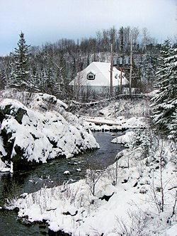
Another small portion of the Englehart River is protected in the Kap-Kig-Iwan Provincial Park, located on the river between the communities of Charlton and Englehart. [3]

Geology

The river's course through Englehart River Fine Sand Plain and Waterway Provincial Park is in the Cross Lake Fault, the northeast facing escarpment of which is the southwest boundary of the Lake Timiskaming Rift Valley. [4]

See also

Related Research Articles

<span class="mw-page-title-main">Sand River (Ontario)</span> River in Ontario, Canada

The Sand River is a river in the Unorganized North Part of Algoma District in Northeastern Ontario, Canada. It is in the Great Lakes Basin, is a tributary of Lake Superior, and its entire course lies within Lake Superior Provincial Park.

<span class="mw-page-title-main">Sturgeon River (Lake Nipissing)</span> River in Ontario, Canada

The Sturgeon River is a river that springs near Lady Evelyn-Smoothwater Provincial Park in the Timiskaming District in Ontario, Canada. It flows 230 kilometres (140 mi) in a mostly south-easterly direction through Sudbury and Nipissing Districts before it empties into Lake Nipissing on the north shore. The town of Sturgeon Falls is located on the river about 3 kilometres (1.9 mi) north of its mouth.

The Brightsand River is a river in the James Bay drainage basin in Unorganized Thunder Bay District in northwestern Ontario, Canada.

The Pukaskwa River is a river in Thunder Bay District and Algoma District in Northern Ontario, Canada. It is in the Great Lakes Basin and is a tributary of Lake Superior, which it enters at the south end of Pukaskwa National Park. It is a remote, pristine, free-flowing, medium-sized Shield river, with lots of whitewater, best travelled in spring.

<span class="mw-page-title-main">Englehart</span> Town in Ontario, Canada

Englehart is a town in the Canadian province of Ontario, located on the Blanche River in the Timiskaming District.

The Obabika River is located in central Ontario, Canada. It is south of Lady Evelyn-Smoothwater Provincial Park and west of Lake Temagami, within Sudbury District. It flows from Obabika Lake in a south-westerly direction and drains into the Sturgeon River. The Obabika River is remote and surrounded by undeveloped wilderness.

<span class="mw-page-title-main">Chamberlain, Ontario</span> Township in Ontario, Canada

Chamberlain is a township in the Canadian province of Ontario, located within the Timiskaming District.

<span class="mw-page-title-main">Tomstown, Ontario</span>

Tomstown is an unincorporated community in the Canadian province of Ontario, located in the unincorporated township of Ingram within the Unorganized, West Part division of Timiskaming District.

<span class="mw-page-title-main">Sturgeon River Provincial Park</span> Provincial park in Ontario, Canada

The Sturgeon River Provincial Park is a provincial park in northern Ontario, Canada, that protects about 70 kilometres (43 mi) long section of the Sturgeon River and its banks, from Woods Lake to the Sudbury-Nipissing District boundary. It was established in 1989 and expanded in 2005. It protects outstanding water routes that provide recreational canoe camping opportunities. Other activities include hunting and fishing.

<span class="mw-page-title-main">Montreal River (Timiskaming District)</span> Tributary of the Ottawa River in Timiskaming District, Ontario, Canada

The Montreal River is a river in Timiskaming District, Ontario, Canada. It travels 220 kilometres (137 mi) from its source at Smoothwater Lake to its mouth at Lake Timiskaming on the Ottawa River. The river is a significant source of hydroelectricity.

Long Lake is a lake formed by the widening of the Englehart River in Timiskaming District of northeastern Ontario, Canada. It consists of several segments and was previously known as Kushog, Kindogami and Robillard Lakes.

<span class="mw-page-title-main">Blanche River (Lake Timiskaming)</span> River in Ontario, Canada

The Blanche River is a river in the Saint Lawrence River drainage basin in Timiskaming District in northeastern Ontario, Canada. The river is a tributary of Lake Timiskaming and its name is from the French for the colour "white".

<span class="mw-page-title-main">Groundhog River</span> River in Northeastern Ontario, Canada

The Groundhog River is a river in Cochrane District and Sudbury District in Northeastern Ontario, Canada. The river is in the James Bay drainage basin and is a left tributary of the Mattagami River.

<span class="mw-page-title-main">Kap-Kig-Iwan Provincial Park</span> Provincial park in Ontario, Canada

Kap-Kig-Iwan Provincial Park is a protected area in the incorporated townships of Charlton and Dack and Evanturel in Timiskaming District in Northeastern Ontario, Canada. Established in 1957, the 325-hectare (803-acre) park is located along the Englehart River, off Ontario Highway 11 about 2 kilometres (1.2 mi) south of the town of Englehart. Kap-Kig-Iwan is classified as a Natural Environment park and is a provincial park of Ontario.

<span class="mw-page-title-main">Misema River</span> River in Ontario, Canada

The Misema River is a river in Timiskaming District and Cochrane District in Northeastern Ontario, Canada. It is in the Saint Lawrence River drainage basin and is a left tributary of the Blanche River.

The Little White River is a river in the Unorganized North Part of Algoma District in Northeastern Ontario, Canada. It is in the Great Lakes Basin and is a left tributary of the Mississagi River.

Lillord Creek is a creek in the Unorganized West Part of Timiskaming District in northeastern Ontario, Canada. It is in the Saint Lawrence River drainage basin and is a right tributary of the Blanche River.

The Makobe River is a river in northeastern Ontario, Canada. It is in the Saint Lawrence River drainage basin, and is a left tributary of the Montreal River.

<span class="mw-page-title-main">Larder River (Ontario)</span> River in Ontario, Canada

The Larder River is a river in Timiskaming District, in Northeastern Ontario, Canada. It is in the Saint Lawrence River drainage basin, and flows from its source at Larder Lake in geographic McFadden Township to its mouth as a left tributary of the Blanche River in the municipal township of Evanturel.

References

  1. "Englehart River". Geographical Names Data Base . Natural Resources Canada . Retrieved 2014-05-13.
  2. "Englehart River near Englehart (02JC001)". Water Survey of Canada - Environment Canada. 2010-04-30. Archived from the original on 2014-05-14. Retrieved 2014-05-15.
  3. 1 2 "Englehart River Fine Sand Plain and Waterway Provincial Park - Interim Management Statement" (PDF). 2006-05-26. Retrieved 2014-05-15.
  4. 1 2 3 4 5 "Englehart River Fine Sand Plain & Waterway Provincial Park Management Statement". ontario.ca. Ontario Ministry of the Environment, Conservation and Parks. 26 May 2006. Retrieved 2 May 2023.
  5. "Englehart River Fine Sand Plain and Waterway Provincial Park". Geographical Names Data Base . Natural Resources Canada . Retrieved 1 May 2023.
  6. 1 2 "Englehart River Fine Sand Plain and Waterway Provincial Park". www.ontarioparks.com. Ontario Parks. Retrieved 1 May 2023.

Other map sources:

Commons-logo.svg Media related to Englehart River at Wikimedia Commons