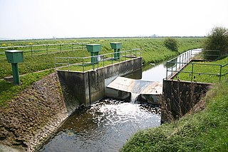
A stream gauge, streamgage or stream gauging station is a location used by hydrologists or environmental scientists to monitor and test terrestrial bodies of water. Hydrometric measurements of water level surface elevation ("stage") and/or volumetric discharge (flow) are generally taken and observations of biota and water quality may also be made. The locations of gauging stations are often found on topographical maps. Some gauging stations are highly automated and may include telemetry capability transmitted to a central data logging facility.

The Fraser Valley is a geographical region in southwestern British Columbia, Canada and northwestern Washington State. It starts just west of Hope in a narrow valley encompassing the Fraser River and ends at the Pacific Ocean stretching from the North Shore Mountains, opposite the city of Vancouver BC, to just south of Bellingham, Washington.

The Pembina River is a tributary of the Red River of the North, approximately 319 miles (513 km) long, in southern Manitoba in Canada and northeastern North Dakota in the United States. It drains an area of the prairie country along the Canada–US border, threading the Manitoba-North Dakota border eastward to the Red River. Via the Red River, Lake Winnipeg and the Nelson River, it is part of the watershed of Hudson Bay.

The River Ryton is a tributary of the River Idle. It rises close to the Chesterfield Canal near Kiveton Park, and is joined by a series of tributaries near Lindrick Common in the Metropolitan Borough of Rotherham, South Yorkshire, England. Most of its course is in Nottinghamshire, flowing through the town of Worksop. It meanders northwards to join the River Idle near the town of Bawtry on the South Yorkshire-Nottinghamshire border.

Hay River, known as "the Hub of the North", is a town in the Northwest Territories, Canada, located on the south shore of Great Slave Lake, at the mouth of the Hay River. The town is separated into two sections, a new town and an old town with the Hay River/Merlyn Carter Airport between them. The town is in the South Slave Region, and along with Fort Smith, the town is home to one of the two regional offices.

The Welland River is a river in the Golden Horseshoe that passes through the Southern Ontario cities of Welland and Niagara Falls. It flows from its source, a Drainage Basin just south of Hamilton, Ontario to meet the Niagara River.

The River Perry is a river in Shropshire, England. It rises near Oswestry and flows south to meet the River Severn above Shrewsbury. Along its 24 miles (39 km) length, its level drops by some 320 feet (95 m). The channel has been heavily engineered, both to enable water mills to be powered by it, and to improve the drainage of the surrounding land. There were at least seven corn mills in the 1880s, and the last one remained operational until 1966. The middle section of the river crosses Baggy Moor, where major improvements were made in 1777 to drain the moor. The scheme was one of the largest to enclose and improve land in North Shropshire, and the quality of the reclaimed land justified the high cost. A section of the river bed was lowered in the 1980s, to continue the process.

The Peel River is a tributary of the Mackenzie River in the Yukon and Northwest Territories in Canada. Its source is in the Ogilvie Mountains in the central Yukon at the confluence of the Ogilvie River and Blackstone River. Its main tributaries are:
The Scottish Environment Protection Agency is Scotland's environmental regulator and national flood forecasting, flood warning and strategic flood risk management authority. Its main role is to protect and improve Scotland's environment. SEPA does this by helping business and industry to understand their environmental responsibilities, enabling customers to comply with legislation and good practice and to realise the economic benefits of good environmental practice. One of the ways SEPA does this is through the NetRegs environmental guidance service. It protects communities by regulating activities that can cause harmful pollution and by monitoring the quality of Scotland's air, land and water. The regulations it implements also cover the storage, transport and disposal of radioactive materials.

The Chilcotin River /tʃɪlˈkoʊtɪn/ located in Southern British Columbia, Canada is a 241 km (150 mi) long tributary of the Fraser River. The name Chilcotin comes from Tŝilhqot’in, meaning "ochre river people," where ochre refers to the mineral used by Tŝilhqot’in Nation and other Indigenous communities as a base for paint or dye. The Chilcotin River, Chilko River and Lake, and Taseko River and Lake make up the Chilcotin River watershed. This 19,200 km2 (7,400 sq mi) watershed drains the Chilcotin Plateau which reaches north to south from the Nechako Plateau to Bridge River county and east to west from Fraser River to the Coast Mountains. It is also one of twelve watersheds that make up the Fraser River Basin. Made up of seven major tributaries, Chilcotin River starts northeast of Itcha Mountain, flowing southeast until it joins the Fraser River south of Williams Lake, 22 km (14 mi) upstream from Gang Ranch.
The Harrison River is a short but large tributary of the Fraser River, entering it near the community of Chehalis, British Columbia, Canada. The Harrison drains Harrison Lake and is the de facto continuation of the Lillooet River, which feeds the lake.

The West Road River or Blackwater River or Tiyakoh is an important tributary of the Fraser River, flowing generally north-eastward from the northern slopes of the Ilgachuz Range and across the Fraser Plateau in the Chilcotin region of central British Columbia, Canada. With only one major tributary, the Nazko River, its confluence with the Fraser is approximately 40 km northwest of Quesnel. It forms the division between the Chilcotin Plateau (S) and the Nechako Plateau (N), which are subdivisions of the Fraser Plateau.

The West Canada Creek is a 76-mile-long (122 km) river in upstate New York, United States. West Canada Creek is an important water way in Hamilton, Oneida, and Herkimer counties, draining the south part of the Adirondack Mountains before emptying into the Mohawk River near the Village of Herkimer. The name "Canada" is derived from an Iroquoian word for "village" (Kanata).

Fortress Mountain was a ski resort in Kananaskis Country, Alberta, Canada.
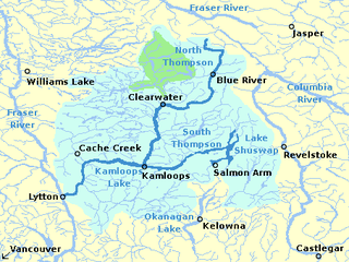
The South Thompson River is the southern branch of the Thompson River, the largest tributary of the Fraser River, in the Canadian province of British Columbia. It originates at the outlet of Little Shuswap Lake at the town of Chase and flows approximately 58 kilometres (36 mi) southwest and west through a wide valley to Kamloops where it joins the North Thompson River to form the main stem Thompson River.

The Moyie River is a 92-mile (148 km) long tributary of the Kootenai River in the U.S. state of Idaho and the Canadian province of British Columbia. The Moyie River is part of the Columbia River basin, being a tributary of the Kootenay River, which is a tributary to the Columbia River.

The Seymour River is a river in North Vancouver, British Columbia which is notable for being several degrees warmer than other streams and lakes in the area. This is due to it being fed from a large reservoir backed up behind a dam from which a constant flow of water is released. The upper portion of the river and the reservoir are part of the Seymour watershed, controlled by Metro Vancouver.

The Bowron River, also formerly named the Bear River and Reid Creek, is a tributary of the Fraser River in the Canadian province of British Columbia. It originates in Bowron Lake Provincial Park of east central British Columbia and flows northwest from the outlet of the Bowron Lakes, then northeast, to join the Fraser River. The river was named after John Bowron, the Gold Commissioner in Barkerville.

Alouette River is a tributary of the Pitt River in the Canadian province of British Columbia.
Green Kenue is an advanced data preparation, analysis, and visualization tool for hydrologic modellers. It is a Windows/OpenGL-based graphical user interface, integrating environmental databases and geo-spatial data with model input and results data. Green Kenue provides complete pre- and post-processing for the WATFLOOD and HBV-EC hydrologic models. Also included is a 1D "reach scale" unsteady hydrodynamic flow solver, Gen1D.
