Englehart

Last updated

Englehart
Town of Englehart
Englehart Ontario.JPG
Main street in Englehart. The ONR train station is visible at the end of the street.
Canada Ontario location map 2.svg
Red pog.svg
Englehart
Coordinates: 47°49′N79°52′W / 47.817°N 79.867°W / 47.817; -79.867
Country Canada
Province Ontario
District Timiskaming District
Government
  MayorJerry Mikovitch
Area
  Land3.02 km2 (1.17 sq mi)
Population
 (2016) [1]
  Total1,479
  Density489.7/km2 (1,268/sq mi)
Time zone UTC-5 (EST)
  Summer (DST) UTC-4 (EDT)
Area code 705
Website www.englehart.ca OOjs UI icon edit-ltr-progressive.svg

Englehart (Canada 2016 Census population 1,479) [1] is a town in the Canadian province of Ontario, located on the Blanche River in the Timiskaming District.

Contents

Kap-Kig-Iwan Provincial Park is located near the town of Englehart.

History

OSB plant in Englehart Englehart ON 2.JPG
OSB plant in Englehart

The Town of Englehart was created by the building of the Temiskaming and Northern Ontario (T & NO) Railway and named after Chairman Jacob Lewis Englehart. It was incorporated as the Town of Englehart in January 1908, as a half-way divisional point between North Bay, Ontario and what became Cochrane, Ontario, where the T & NO Railway met with the new Transcontinental Railway line (now the CNR) being built west from Quebec City across the north to the Western Provinces, creating the town of Cochrane. [2]

In 1905, Jacob Lewis Englehart, from Ohio, became a key figure in the development of the railway north of North Bay in Ontario. [3] A successful businessman from Petrolia, Ontario, nearing the current age of retirement, he was appointed in 1905, by the Premier of Ontario, to the Ontario Commission in charge of building and operating the T & NO, which would, about 1945, become the Ontario Northland Railway. He served as Chairman of a new 3-man Commission from 1906 until the fall of 1919, when he retired after the United Farmers of Ontario won their first and only four-year term in the Province of Ontario. He died at York, now Toronto, in 1921 and was buried at Petrolia.[ citation needed ]

The new community of Englehart began to take shape with the construction of the line's first major bridge at the Charlton branch of Blanche River (Initially, there was a construction site for a high level trestle known as Blanche River Crossing, which opened in 1906. The Commission decided to develop a planned town on the west side of the river, from 1906-1908, as a half-way divisional point on the railway.[ citation needed ]

The railway was particularly central to the settlement and development of New Ontario (now N.E. Ont.); that is, until the first gravel road,(the Ferguson Highway, now part of Highway 11) was opened in 1927 north from North Bay to New Liskeard in the Temiskaming District, with future extensions north and west as the initial Trans-Canada Highway route.[ citation needed ]

The T & NO was eventually extended north to Moosonee on James Bay in the depression years of the 1930s. Today, Englehart's importance as a railway town has diminished, and the biggest employer is an oriented strand board (OSB) facility built by Grants Forest Products, which was sold to Georgia-Pacific in early 2010 as a result of the recession of 2008.[ citation needed ]

Demographics

Historical census populations – Englehart
YearPop.±%
1986 1,740    
1991 1,726−0.8%
1996 1,703−1.3%
2001 1,595−6.3%
2006 1,494−6.3%
2011 1,519+1.7%
2016 1,479−2.6%
Source: Statistics Canada

In the 2021 Census of Population conducted by Statistics Canada, Englehart had a population of 1,442 living in 684 of its 720 total private dwellings, a change of -2.5% from its 2016 population of 1,479. With a land area of 2.92 km2 (1.13 sq mi), it had a population density of 493.8/km2 (1,279.0/sq mi) in 2021. [4]

Canada census – Englehart community profile
2021 2016 2011
Population1,442 (-2.5% from 2016)1,479 (-2.6% from 2011)1,519 (1.7% from 2006)
Land area2.92 km2 (1.13 sq mi)3.02 km2 (1.17 sq mi)3.04 km2 (1.17 sq mi)
Population density494.2/km2 (1,280/sq mi)489.7/km2 (1,268/sq mi)499.9/km2 (1,295/sq mi)
Median age46.4 (M: 41.6, F: 50.8)48.1 (M: 45.9, F: 49.8)49.4 (M: 46.2, F: 52.0)
Private dwellings720 (total)  684 (occupied)711 (total) 727 (total) 
Median household income$67,500$56,768
References: 2021 [5] 2016 [6] 2011 [7] earlier [8] [9]

Media

CJBB-FM broadcasts a country music radio format on from Englehart on 103.1 FM.

Transportation

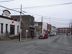
The Englehart railway station was served by the Northlander until the passenger service was ended in September 2012. Rail passenger service was replaced by increased bus service, also provided by Ontario Northland Railway. Englehart is located on Ontario Highway 11, part of the Trans-Canada Highway system.

On March 31, 2007, an Ontario Northland Railway freight train derailed about 15 kilometres (9.3 mi) north of Englehart, spilling an estimated 100 tonnes of sulfuric acid into a creek feeding the Blanche River. [10] [11]

See also

Related Research Articles

<span class="mw-page-title-main">Swastika, Ontario</span> Community town in Ontario, Canada

Swastika is a small community founded around a mine site in Northern Ontario, Canada in 1908. Today it is within the municipal boundaries of Kirkland Lake, Ontario. It has frequently been noted on lists of unusual place names.

<span class="mw-page-title-main">Moosonee</span> Town in Ontario, Canada

Moosonee is a town in northern Ontario, Canada, on the Moose River approximately 19 km (12 mi) south of James Bay. It is considered to be "the Gateway to the Arctic" and has Ontario's only saltwater port. Nearby on Moose Factory Island is the community of Moose Factory to which it is connected by water taxi in the summer and ice road in the winter.

<span class="mw-page-title-main">Ontario Northland Railway</span> Railway in Northern Ontario, Canada

The Ontario Northland Railway is a Canadian railway operated by the Ontario Northland Transportation Commission, a provincial Crown agency of the government of Ontario.

<span class="mw-page-title-main">Timiskaming District</span> District in Ontario, Canada

Timiskaming is a district and census division in Northeastern Ontario in the Canadian province of Ontario. The district was created in 1912 from parts of Algoma, Nipissing, and Sudbury districts. In 1921, Cochrane District was created from parts of this district and parts of Thunder Bay District.

<span class="mw-page-title-main">Espanola, Ontario</span> Town in Ontario, Canada

Espanola is a town in Northern Ontario, Canada, in the Sudbury District. It is situated on the Spanish River, approximately 70 kilometres (43 mi) west of downtown Sudbury, and just south of the junction of Highway 6 and Highway 17. The town is where the first experimental rules for the sport of ringette were created in 1963 by Mirl Arthur "Red" McCarthy using a group of local high school girls. Today, Espanola is considered "The Home of Ringette" while North Bay, Ontario, is considered the "Birthplace of Ringette" though the title of "birthplace of ringette" is often shared by both.

<span class="mw-page-title-main">Temiskaming Shores</span> City in Ontario, Canada

Temiskaming Shores is a city in the Timiskaming District in Northeastern Ontario, Canada. It was created by the amalgamation of the town of New Liskeard, the town of Haileybury, and the township of Dymond in 2004. The city had a total population of 9,634 in the Canada 2021 Census. Temiskaming Shores is Ontario's second-smallest city, in terms of population, after Dryden. Haileybury is the seat of Timiskaming District.

<span class="mw-page-title-main">Cochrane, Ontario</span> Town in Ontario, Canada

Cochrane is a town in northeastern Ontario, Canada. It is located east of Kapuskasing, northeast of Timmins, south of Moosonee, and north of Iroquois Falls. It is about a one-hour drive from Timmins, the major city of the region. It is the seat of Cochrane District. The town's population is made up of about half anglophone and half francophone residents.

<span class="mw-page-title-main">Sables-Spanish Rivers</span> Township in Ontario, Canada

Sables-Spanish Rivers is a township in Ontario, Canada, on the north shore of Georgian Bay. It is located in the Sudbury District, approximately 70 kilometres (43 mi) west of Sudbury.

<span class="mw-page-title-main">Burk's Falls</span> Village in Ontario, Canada

Burk's Falls is an incorporated village in the Almaguin Highlands region of Parry Sound District, Ontario, Canada, located 265 kilometres (165 mi) north of Toronto and 90 kilometres (56 mi) south of North Bay, Ontario. The village, and the waterfall on the site, were named by David Francis Burk of Oshawa, after he selected the land surrounding the waterfall in the Free Land Grant Act. Burk's Falls is part of the Magnetawan River waterway.

<span class="mw-page-title-main">Marathon, Ontario</span> Town in Ontario, Canada

Marathon is a town in the Canadian province of Ontario, located in Thunder Bay District, on the north shore of Lake Superior north of Pukaskwa National Park.

<span class="mw-page-title-main">Nipigon</span> Township in Ontario, Canada

Nipigon is a township in Thunder Bay District, Northwestern Ontario, Canada, located along the west side of the Nipigon River and south of the small Lake Helen running between Lake Nipigon and Lake Superior. Lake Nipigon is located approximately 25 kilometres (16 mi) north of Nipigon. Located at latitude 49.0125° N, Nipigon is the northernmost community on the Great Lakes.

<span class="mw-page-title-main">Unorganized North Algoma District</span> Unorganized area in Ontario, Canada

Unorganized North Algoma District is an unorganized area in northeastern Ontario, Canada, comprising all areas in Algoma District, north of the Sault Ste. Marie to Elliot Lake corridor, which are not part of an incorporated municipality or a First Nation. It covers 44,077.03 km2 (17,018.24 sq mi) of land, and had a population of 6050 in 2021. Many of these communities were/are stations on the Algoma Central Railway or were logging/mining towns.

<span class="mw-page-title-main">Latchford, Ontario</span> Town in Ontario, Canada

Latchford is a single-tier municipality town in Timiskaming District in Northeastern Ontario, Canada. It is located on Bay Lake on the Montreal River, near the town of Cobalt and the municipality of Temagami, and is 20 kilometres from the city of Temiskaming Shores. The population of the town in the Canada 2011 Census was 387, which makes it the smallest town by population in Ontario. The town's slogan is "The Best Little Town by a Dam Site!"

<span class="mw-page-title-main">Gogama</span> Place in Ontario, Canada

Gogama is a Northeastern Ontario community that is situated on Lake Minisinakwa, 580 kilometres north of Toronto, 191 km north of Sudbury, and 114 km south of Timmins. In the Canada 2011 Census, a population of 277 people was recorded. The community is counted as part of Sudbury, Unorganized, North Part in Canadian census data. It is not an incorporated municipality, but is administered by a local services board.

<span class="mw-page-title-main">James, Ontario</span> Township in Ontario, Canada

James is an incorporated township in the Canadian province of Ontario, located in Timiskaming District. The primary community within the township is Elk Lake, which is located at the junction of Ontario Highway 65 and Ontario Highway 560.

<span class="mw-page-title-main">Chamberlain, Ontario</span> Township in Ontario, Canada

Chamberlain is a township in the Canadian province of Ontario, located within the Timiskaming District.

<span class="mw-page-title-main">Charlton and Dack</span> Municipality in Ontario, Canada

Charlton and Dack is a municipality in the Canadian province of Ontario, located within the Timiskaming District. Its population in 2016 was 686.

<span class="mw-page-title-main">Ontario Northland Transportation Commission</span> Crown agency of the Government of Ontario

<span class="mw-page-title-main">Ontario Northland Motor Coach Services</span>

Ontario Northland Motor Coach Services is an intercity bus service operated by the Ontario Northland Transportation Commission, a Crown agency of the government of Ontario, Canada. Ontario Northland Motor Coach Services operates passenger and parcel transportation service in northern Ontario, with additional routes connecting northern Ontario to the Greater Toronto Area, Winnipeg, and Ottawa.

<span class="mw-page-title-main">Blanche River (Lake Timiskaming)</span> River in Ontario, Canada

The Blanche River is a river in the Saint Lawrence River drainage basin in Timiskaming District in northeastern Ontario, Canada. The river is a tributary of Lake Timiskaming and its name is from the French for the colour "white".

References

  1. 1 2 "Census Profile, 2016 Census: Englehart". Statistics Canada. 8 February 2017. Retrieved July 18, 2019.
  2. "Founding of Englehart". Ontario Heritage Trust. Retrieved July 18, 2019.
  3. "Englehart". Dictionary of Canadian Biography (online ed.). University of Toronto Press. 1979–2016.
  4. "Population and dwelling counts: Canada, provinces and territories, census divisions and census subdivisions (municipalities), Ontario". Statistics Canada. February 9, 2022. Retrieved March 30, 2022.
  5. "2021 Community Profiles". 2021 Canadian Census . Statistics Canada. February 4, 2022. Retrieved 2023-10-19.
  6. "2016 Community Profiles". 2016 Canadian Census . Statistics Canada. August 12, 2021. Retrieved 2021-01-04.
  7. "2011 Community Profiles". 2011 Canadian Census . Statistics Canada. March 21, 2019. Retrieved 2021-01-04.
  8. "2006 Community Profiles". 2006 Canadian Census . Statistics Canada. August 20, 2019.
  9. "2001 Community Profiles". 2001 Canadian Census . Statistics Canada. July 18, 2021.
  10. "Derailed train spills acid into Ontario river". cbc.ca. 2007-03-31. Retrieved 2007-04-02.
  11. "Ontario rail line shut down after derailment spill". cbc.ca. 2007-04-02. Retrieved 2007-04-02.