
Algonquin Provincial Park is an Ontario provincial park located between Georgian Bay and the Ottawa River, mostly within the Unorganized South Part of Nipissing District. Established in 1893, it is the oldest provincial park in Canada. Additions since its creation have increased the park to its current size of about 7,653 km2 (2,955 sq mi). The park is contiguous with several smaller, administratively separate provincial parks that protect important rivers in the area, resulting in a larger total protected area.

Coboconk, often shortened to Coby, is a community in the city of Kawartha Lakes, in the south-central portion of the Canadian province of Ontario. The village lies at the junction of Highway 35 and former Highway 48, on the northern tip of Balsam Lake, the highest point on the Trent–Severn Waterway. Coboconk has a prominent role in the logging, limestone, and tourism industries of the Kawartha Lakes region over the past 150 years.

The City of Kawartha Lakes is a unitary municipality in Central Ontario, Canada. It is a municipality legally structured as a single-tier city; however, Kawartha Lakes is the size of a typical Ontario county and is mostly rural. It is the second largest single-tier municipality in Ontario by land area.

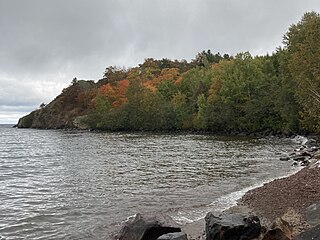
Lake Superior Provincial Park is one of the largest provincial parks in Ontario, covering about 1,550 square kilometres (600 sq mi) along the northeastern shores of Lake Superior between Sault Ste. Marie and Wawa in Algoma District in Northeastern Ontario, Canada. Ontario Highway 17 now runs through the park. When the park was established by Ontario in 1944, there was no road access.
Pancake Bay Provincial Park was established in 1968 by Ontario Parks. It is a recreation-class provincial park created to help preserve the fragile beach dune ecology. There are 325 campsites, including 160 with electricity. There are three comfort stations. Yurt camping is available in the park. Group camping sites are also available.
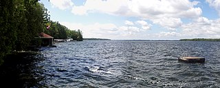
Balsam Lake is a lake in the City of Kawartha Lakes in Central Ontario, Canada. It is in the Great Lakes Basin, is one of the lakes of the Kawartha Lakes, and is at the summit of the Trent–Severn Waterway.

Bon Echo Provincial Park is a provincial park in southeastern Ontario, Canada, approximately 6 kilometres (3.7 mi) north of Cloyne. The park is within township boundaries of both North Frontenac and Addington Highlands, roughly separated by Highway 41.
Crimson Lake Provincial Park is a provincial park located in Alberta, Canada, 14 kilometres (8.7 mi) west of Rocky Mountain House, off the David Thompson Highway along secondary highway 756.

Miquelon Lake Provincial Park is a provincial park in Alberta, Canada, about 65 kilometres southeast of the city of Edmonton. The park features several lakes, the largest of them being Miquelon Lake.

Governor Dodge State Park is a 5,270-acre (2,133 ha) Wisconsin state park outside Dodgeville in Iowa County, Wisconsin. Named after Henry Dodge, the first governor of the Wisconsin Territory, the park contains geologic features indicative of the Driftless Area. It is located 4.1 miles north of the Central business district of the City of Dodgeville.

Golden Ears Provincial Park is a 555.9 square kilometres (214.6 sq mi) provincial park in British Columbia, Canada. It is named after the prominent twin peaks, which are commonly referred to as Golden Ears. The park was originally part of Garibaldi Provincial Park but was split off as a separate park in 1967. The area was logged extensively in the 1920s by the Lougheed and Abernathy Logging Company. Many recreational attractions are found within the park. Golden Ears Provincial Park is a protected area that contains many endangered species of flora and fauna.

The Current River Greenway is a 263 hectare greenway located in Current River neighbourhood in the north end of Thunder Bay, Ontario along the Current River.

Meadow Lake Provincial Park is a northern boreal forest provincial recreational park along the Waterhen and Cold Rivers in the Canadian province of Saskatchewan. The park was founded on 10 March 1959, is the largest provincial park in Saskatchewan, and encompasses over 25 lakes in an area of 1,600 km2 (620 sq mi). The park was named "Meadow Lake" after the city of Meadow Lake and Meadow Lake. The city and the lake are not in the park and are located about 40 kilometres (25 mi) south-east of the nearest park entrance, which is about 5 kilometres (3.1 mi) north of Dorintosh. The length of the park stretches about 113 kilometres (70 mi) from Cold Lake on the Saskatchewan / Alberta border in the west to the eastern shore of Waterhen Lake in the east.
The Gull River is a river in Algonquin Highlands and Dysart et al, Haliburton County and the single-tier municipality of Kawartha Lakes in south-central Ontario, Canada. It is in the Trent River and Lake Ontario drainage basins, and flows from southern Algonquin Provincial Park to Balsam Lake on the Trent–Severn Waterway.

Lake Fausse Pointe State Park is located in Iberia Parish, Louisiana and St. Martin Parish, Louisiana, USA. It is located about 18 miles (29 km) east of St. Martinville adjacent to the Atchafalaya Basin. The park is 6,000 acres (2,400 ha) in size and was once the home of the Chitimacha Indians.

Driftwood Provincial Park is a provincial park on the south shore of the Ottawa River, about 40 kilometres (25 mi) west of Deep River, in Ontario, Canada. It is administered by Ontario Parks which classifies it as a "recreation park".
Caliper Lake Provincial Park is a small provincial park in northwestern Ontario, near the township of Nestor Falls. The park occupies 147 hectares alongside Caliper Lake. The facility is open for day use and overnight camping from mid-May to mid-September. The park features 83 campsites, many with electrical hookups, and some which may be rented for the entire season. The park offers many amenities, including a sandy beach, hiking trails, playground equipment, fish cleaning facilities, boat launches, bathrooms, and showers. Canoes, kayaks, and bicycles are available for rental.
Greenwater Lake Provincial Park is a provincial park in the Canadian province of Saskatchewan. It is located on the eastern side of the province in the Porcupine Hills on Highway 38. The closest town, Porcupine Plain, is about 28 kilometres (17 mi) to the north-east of the park visitor centre. Founded on 19 February 1932, Greenwater is one of the oldest provincial parks in Saskatchewan. The original six parks were established in 1931 and Greenwater Provincial Park was added one year later. In 1964, the park was expanded to its current size.

Good Spirit Lake Provincial Park is a provincial park on the eastern side of the Canadian province of Saskatchewan. Founded in 1931, the park surrounds the western and southern shores of Good Spirit Lake and is one of Saskatchewan's six founding provincial parks. The park is in the RM of Good Lake No. 274, about 48 kilometres (30 mi) north of the city of Yorkton. Highway 47 runs along the western boundary and Highway 229 provides access to the park's amenities.
Great Blue Heron Provincial Park is a recreational park in the central region of the Canadian province of Saskatchewan in the boreal forest ecozone of Canada. It is adjacent to the eastern boundary of Prince Albert National Park, about 50 kilometres (31 mi) north of the city of Prince Albert. The provincial park was established in 2013 from two pre-existing provincial recreation sites – Emma Lake and Anglin Lake Recreation Sites – and the addition of a large tract of Crown land.


