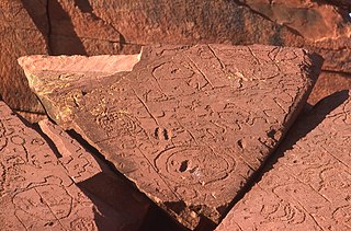
A petroglyph is an image created by removing part of a rock surface by incising, picking, carving, or abrading, as a form of rock art. Outside North America, scholars often use terms such as "carving", "engraving", or other descriptions of the technique to refer to such images. Petroglyphs, estimated to be 20,000 years old are classified as protected monuments and have been added to the tentative list of UNESCO's World Heritage Sites. Petroglyphs are found worldwide, and are often associated with prehistoric peoples. The word comes from the Greek prefix petro-, from πέτρα petra meaning "stone", and γλύφω glýphō meaning "carve", and was originally coined in French as pétroglyphe.

In archaeology, rock arts are human-made markings placed on natural surfaces, typically vertical stone surfaces. A high proportion of surviving historic and prehistoric rock art is found in caves or partly enclosed rock shelters; this type also may be called cave art or parietal art. A global phenomenon, rock art is found in many culturally diverse regions of the world. It has been produced in many contexts throughout human history. In terms of technique, the four main groups are:

The Jeffers Petroglyphs site is an outcrop in southwestern Minnesota with pre-contact Native American petroglyphs. The petroglyphs are pecked into rock of the Red Rock Ridge, a 23-mile (37 km)-long Sioux quartzite outcrop that extends from Watonwan County, Minnesota to Brown County, Minnesota. The exposed surface is approximately 150 by 650 feet and surrounded by virgin prairie. "The site lies in an area inhabited in the early historic period by the Dakota Indians, and both the style and form of some of the carvings are identical with motifs that appear on Dakota hide paintings and their quill designs and beadwork. Others are foreign to this Plains Indian tradition and seem to be much earlier in origin." Several old wagon trail ruts traverse the site, one of which is believed to be the old stage coach route from New Ulm, Minnesota to Sioux Falls, South Dakota.

Petroforms, also known as boulder outlines or boulder mosaics, are human-made shapes and patterns made by lining up large rocks on the open ground, often on quite level areas. Petroforms in North America were originally made by various Native American and First Nation tribes, who used various terms to describe them. Petroforms can also include a rock cairn or inukshuk, an upright monolith slab, a medicine wheel, a fire pit, a desert kite, sculpted boulders, or simply rocks lined up or stacked for various reasons. Old World petroforms include the Carnac stones and many other megalithic monuments.

Writing-on-Stone Provincial Park is located about 100 kilometres (60 mi) southeast of Lethbridge, Alberta, Canada, or 44 kilometres (30 mi) east of the community of Milk River, and straddles the Milk River itself. It is one of the largest areas of protected prairie in the Alberta park system, and serves as both a nature preserve and protection for many First Nations (indigenous) rock carvings and paintings. The park is sacred to the Blackfoot and many other aboriginal tribes.

Petroglyph Provincial Park is a Canadian provincial park located at the south end of the city of Nanaimo, British Columbia. The park was established on August 24, 1948, to protect a collection of petroglyphs found near the estuary of the Nanaimo River.

Sanilac Petroglyphs Historic State Park is a state park in the U.S. state of Michigan. The park, also known as ezhibiigadek asin consists of 240 acres (97 ha) in Greenleaf Township, Sanilac County, in Michigan's Thumb. It contains the largest collection of Native American petroglyphs in Michigan. The carvings were created in the pre-Columbian era and represent aspects of Native American spirituality. An interpretive hiking trail within the park passes along the nearby Cass River.
The Crow Canyon Archaeological District is located in the heart of the Dinétah region of the American Southwest in Rio Arriba and San Juan counties in New Mexico approximately 30 miles southeast of the city of Farmington. This region, known to be the ancestral homeland of the Navajo people, contains the most extensive collection of Navajo and Ancient Pueblo petroglyphs or rock art in the United States. Etched into rock panels on the lower southwest walls of the canyon are petroglyphs or rock art depicting what is believed to be ceremonial scenes and symbolic images that represent the stories, traditions and beliefs of the Navajo people. Dating back to the 16th, 17th, and 18th centuries, the petroglyphs have maintained their integrity despite the environmental conditions of the canyon and the effects of tourism. Among the ruins in the Crow Canyon Archaeological District there is also a cluster of Navajo defensive structures or pueblitos, which were built in the 18th century during periods of conflict with the Utes and the beginnings of Spanish Colonialism.

Sydney rock engravings, or Sydney rock art, are a form of Australian Aboriginal rock art in the sandstone around Sydney, New South Wales, Australia, that consist of carefully drawn images of people, animals, or symbols. Many thousands of such engravings are known to exist in the Sydney region, although the locations of most are not publicised to prevent damage by vandalism, and to retain their sanctity, as they are still regarded as sacred sites by Indigenous Australians. There are two art environments in Sydney Basin, rock shelters and engraving sites.
The Leo Petroglyph is a sandstone petroglyph containing 37 images of humans and other animals as well as footprints of each. The petroglyph is located near the small village of Leo, Ohio and is thought to have been created by the Fort Ancient peoples. The area in which the sandstone petroglyph was found is on the edge of an unglaciated Mississippian sandstone cliff 20–65 feet (6.1–19.8 m) high. A 20 by 16 feet slab containing the 37 carvings is protected by a wooden shelter, a Works Progress Administration project. The meanings of the drawings are unknown. On November 10, 1970, it was added to the National Register of Historic Places. The site is maintained by the Ohio History Connection.

Serpent Mounds Park is a historical place located near Keene, Ontario, Canada. Serpent Mounds operated as a provincial park, established in 1955 through a lease with the Hiawatha First Nation, of the Michi Saagiig. In 1982, while operating as a provincial park the mounds were designated a National Historic Site, including East Sugar Island.
The Napwerte /Ewaninga Rock Carvings Conservation Reserve is a protected area in the Northern Territory of Australia consisting of an area of low sand dunes, rocky outcrops and a claypan about 35 kilometres (22 mi) south of Alice Springs. It is significant because of a large number of Aboriginal rock carvings and it is a sacred men's site of the Arrernte people who are its Traditional Owners.

Saymaluu-Tash is a petroglyph site and a national park in Jalal-Abad Region, Kyrgyzstan, south of Kazarman. Over 10,000 stones bear pictures—perhaps as many as 98,000 pictures in all—which are black-and-white rock paintings, making the site a globally important collection of rock art. The pictures have been pecked into the near black or grey shiny desert varnish covering many rocks. Most pictures are from the Bronze Age and show animals, humans and symbols. They may partly be seen as a sacred display of offerings of the ancient people of the lower valley.

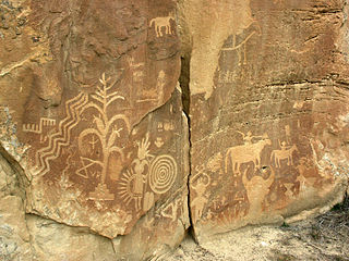
Coso Rock Art District is a rock art site containing over 100,000 Petroglyphs by Paleo-Indians and/or Native Americans. The district is located near the towns of China Lake and Ridgecrest, California. Big and Little Petroglyph Canyons were declared a National Historic Landmark in 1964. In 2001, they were incorporated into this larger National Historic Landmark District. There are several other distinct canyons in the Coso Rock Art District besides the Big and Little Petroglyph Canyons. Also known as Little Petroglyph Canyon and Sand Tanks, Renegade Canyon is but one of several major canyons in the Coso Range, each hosting thousands of petroglyphs. The majority of the Coso Range images fall into one of six categories: bighorn sheep, entopic images, anthropomorphic or human-like figures, other animals, weapons & tools, and "medicine bag" images. Scholars have proposed a few potential interpretations of this rock art. The most prevalent of these interpretations is that they could have been used for rituals associated with hunting.

The Barnesville Petroglyph petroglyph site in the eastern part of the U.S. state of Ohio. Located approximately 3 miles (4.8 km) southwest of the village of Barnesville in Belmont County, the petroglyphs have been known both by archaeologists and the general public since the 1850s or earlier. Although the site was significantly damaged during the twentieth century, it is still a significant archaeological site, and has been named a historic site.
Aboriginal sites of New South Wales consist of a large number of places in the Australian state of New South Wales where it is still possible to see visible signs of the activities and culture of the Australian Aboriginals who previously occupied these areas.

The Sugar Grove Petroglyphs are a group of petroglyphs in the southwestern part of the U.S. state of Pennsylvania. Located on an outcrop of sandstone in Monongahela Township near the eastern edge of Greene County, the petroglyphs have been known since at least the 1930s. Due to their value as an archaeological site, the petroglyphs have been named a historic site.

Judaculla Rock is a curvilinear-shaped outcrop of soapstone known for its ancient carvings and petroglyphs. The archaeological site is located on a 0.85-acre rectangular-shaped property, now owned by Jackson County. It is approximately 60 meters east of Caney Fork Creek, a major branch of the northwestward-trending Tuckasegee River in the mountains of Western North Carolina.

The Sacred Rocks of Hunza or Haldeikish constitute one of the earliest sites of Petroglyphs along the ancient Silk Route. It is a cultural heritage site in Gilgit-Baltistan region of northern Pakistan. The carvings on the rocks dates back to the 1st Millennium AD.

St. Victor Petroglyphs Provincial Historic Park is a historical provincial park in the Canadian province of Saskatchewan. The park is located in the RM of Willow Bunch No. 42, about 2 kilometres (1.2 mi) south of St. Victor. The 3.9 ha park is situated on the northern slope of the Wood Mountain Upland on a cliff at the top of a partially wooded coulee. The Wood Mountain Hills are a plateau east of the Cypress Hills along the Missouri Coteau in the semi-arid Palliser's Triangle. The site was designated as an historic site in the 1960s and became a provincial park in 1986.