
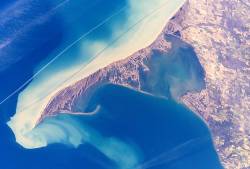
The Danube Delta is the second largest river delta in Europe, after the Volga Delta, and is the best preserved on the continent. Occurring where the Danube River empties into the Black Sea, most of the Danube Delta lies in Romania, with a small part located in Ukraine. Its approximate surface area is 4,152 square kilometres, of which 3,446 km2 (1,331 sq mi) is in Romania. With the lagoons of Razim–Sinoe, located south of the main delta, the total area of the Danube Delta is 5,165 km2 (1,994 sq mi). The Razim–Sinoe lagoon complex is geologically and ecologically related to the delta proper; the combined territory is listed as a World Heritage Site.

Point Pelee National Park is a national park in Essex County in southwestern Ontario, Canada where it extends into Lake Erie. The word pelée is French for 'bald'. Point Pelee consists of a peninsula of land, mainly of marsh and woodland habitats, that tapers to a sharp point as it extends into Lake Erie. Middle Island, also part of Point Pelee National Park, was acquired in 2000 and is just north of the Canada–United States border in Lake Erie. Point Pelee is the southernmost point of mainland Canada, and is located on a foundation of glacial sand, silt and gravel that bites into Lake Erie. This spit of land is slightly more than seven kilometres long by 4.5 kilometres (2.8 mi) wide at its northern base. Established in 1918, Point Pelee was the first national park in Canada to be established for conservation. It was designated as a Ramsar site on 27 May 1987.
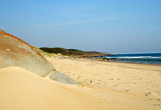
The Croajingolong National Park is a coastal national park located in the East Gippsland region of the Australian state of Victoria. The 88,355-hectare (218,330-acre) national park is situated approximately 450 kilometres (280 mi) east of Melbourne and 500 kilometres (310 mi) south of Sydney.

The Niagara Escarpment is a long escarpment, or cuesta, in Canada and the United States that starts from the south shore of Lake Ontario westward, circumscribes the top of the Great Lakes Basin running from New York through Ontario, Michigan, and Wisconsin. The escarpment is the cliff over which the Niagara River plunges at Niagara Falls, for which it is named.

The Thousand Islands – Frontenac Arch region or the Frontenac Axis is an exposed strip of Precambrian rock in Canada and the United States that links the Canadian Shield from Algonquin Park with the Adirondack Mountain region in New York, an extension of the Laurentian Mountains of Québec. The Algonquin to Adirondacks region, which includes the Frontenac Axis or Arch, is a critical linkage for biodiversity and resilience, and one with important conservation potential. The axis separates the St. Lawrence Lowlands and the Great Lakes Lowlands. It has many distinctive plant and animal species. It is one of four ecoregions of the Mixedwood Plains.
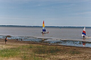
Long Point is a sand spit and medium-sized hamlet on the north shore of Lake Erie, part of Norfolk County in the province of Ontario, Canada.
Lake Saint Pierre is a lake in Quebec, Canada, a widening of the Saint Lawrence River between Sorel-Tracy and Trois-Rivières. It is located downstream, and northeast, of Montreal; and upstream, and southwest, of Quebec City. The end of the lake delimits the beginning of the estuary of Saint Lawrence.
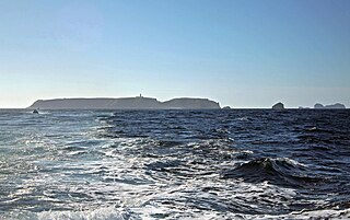
The Berlengas are a Portuguese archipelago consisting of small Atlantic islands 10 to 17 kilometres off the coast of Peniche, Portugal, in the Oeste region. These islands were traditionally known to British mariners as "the Burlings". The only inhabited island is its largest island, Berlenga Grande, although there is currently no permanent habitation in the archipelago. The other islands are grouped into two groups of islets, the Estelas Islets and the Farilhões-Forcados Islets.
UNESCO Biosphere Reserves are environment-protected scientific-research institutions of international status that are created with the intent for conservation in a natural state the most typical natural complexes of biosphere, conducting background ecological monitoring, studying of the surrounding natural environment, its changes under the activity of anthropogenic factors.

Presqu'ile Provincial Park is a park in southeastern Northumberland County on the north shore of Lake Ontario near the town of Brighton in Ontario, Canada. The park occupies an area of 9.37 km2 (3.62 sq mi). The name of the park is the French word for peninsula, or literally "almost island", and was believed to be named by Samuel De Champlain on his second expedition. The peninsula was formed when a limestone island was connected to the mainland by a sand spit; this kind of formation is referred to as a tombolo.

Rondeau Provincial Park is the second oldest provincial park in Ontario, Canada, having been established with an order in council on 8 September 1894. The park is located in Southwestern Ontario, on an 8 km long crescentic sand spit extending into Lake Erie. Rondeau is home to the largest area of Carolinian forest in Canada, a long sand beach, a large marsh, approximately half of Rondeau Bay, campgrounds and a cottage community. The name of the park comes from the French words "ronde eau" or "round water" which describes the shape of the harbour sheltered by the peninsula.
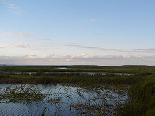
Long Point Provincial Park is a provincial park on the northwest shore of Lake Erie near Port Rowan, Ontario, Canada. The park is part of a sandy spit of land called Long Point that juts out into the lake. It covers part of the area of Long Point Biosphere Reserve, which was designated a UNESCO Biosphere Reserve because of its biological significance.
Blakeney Point is a national nature reserve situated near to the villages of Blakeney, Morston and Cley next the Sea on the north coast of Norfolk, England. Its main feature is a 6.4 km (4.0 mi) spit of shingle and sand dunes, but the reserve also includes salt marshes, tidal mudflats and reclaimed farmland. It has been managed by the National Trust since 1912, and lies within the North Norfolk Coast Site of Special Scientific Interest, which is additionally protected through Natura 2000, Special Protection Area (SPA), International Union for Conservation of Nature (IUCN) and Ramsar listings. The reserve is part of both an Area of Outstanding Natural Beauty (AONB), and a World Biosphere Reserve. The Point has been studied for more than a century, following pioneering ecological studies by botanist Francis Wall Oliver and a bird ringing programme initiated by ornithologist Emma Turner.

Cuspate forelands, also known as cuspate barriers or nesses in Britain, are geographical features found on coastlines and lakeshores that are created primarily by longshore drift. Formed by accretion and progradation of sand and shingle, they extend outwards from the shoreline in a triangular shape.

The wildlife of Canada or biodiversity of Canada consist of over 80,000 classified species, and an equal number thought yet to be recognized. Known fauna and flora have been identified from five kingdoms: protozoa represent approximately 1% of recorded species; chromist ; fungis ; plants ; and animals. Insects account for nearly 70 percent of documented animal species in Canada. More than 300 species are found exclusively in Canada.
Biosphere reserves are established according to the UNESCO's Man and the Biosphere Programme (MAB) to promote sustainable development for conservation of biological and cultural diversity. As of 2016, the Lal Suhanra Biosphere Reserve and Ziarat Juniper Forest are the only two biosphere reserve in Pakistan, which were approved by UNESCO in 1977 and 2013 respectively. A number of initiatives and projects have been undertaken to promote and develop other biosphere reserves in Pakistan but due to weak implementation this has not yet been materialized. In July 2012, Pakistan Museum of Natural History and Beijing Museum of Natural History signed a MoU to work on trans-boundary biodiversity and to improve MAB related activities in the Karakoram, Himalaya, and Hindukush regions.

The wildlife of Ukraine consists of its diverse fauna, flora and funga. The reported fauna consists of 45,000 species when including the areas of the Black Sea and the Sea of Azov. Ukraine's protected environments consist of 33 Ramsar sites covering an area of 7,446.51 square kilometres (2,875.11 sq mi). Biosphere nature reserves and three national parks are all part of the GEF projects portfolio of conservation of biodiversity in the Danube Delta. Their vegetation pattern is mixed forest area, forest-steppe area, steppe area, Ukrainian Carpathian Mountains and Crimean Mountains. Some of the protected areas that were reserves or parks are subsumed under the biosphere reserves.
The Bogeda Biosphere Reserve, also known in English as Bogda Biosphere Reserve, is located in the eastern region of the Tianshan Mountains in China's Xinjiang Province. Local residents named the area the Sangong River Valley after one of the largest rivers in this region, which originates from Bogda Peak. Altogether, five major landscapes are distributed throughout the northern and southern areas of the biosphere reserve: ice-snow belts, alpine and sub-alpine meadow belts, forest belts, steppe belts and sand desert dunes. The topography consists of a middle mountain belt, low mountain erosion hills and alluvial areas. Tianchi Lake is the only natural lake in the region and lies adjacent to the Sangong River.
Big Creek is a watercourse in Norfolk County, Ontario. It is approximately 60 kilometres (37 mi) long. It empties into Lake Erie, at Port Rowan, at Long Point. Its watershed covers 730 square kilometres (280 sq mi), alternately 750 square kilometres (290 sq mi).

The Long Point National Wildlife Area is a Protected area of Canada and one of ten National Wildlife Areas in Ontario. It is the core area of the Long Point Biosphere Reserve, created in 1986, and has been recognized as a Ramsar site since 1982.


