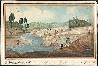
The Cataraqui River forms the lower portion of the Rideau Canal and drains into Lake Ontario at Kingston, Ontario. The name is taken from the original name for Kingston, Ontario; its exact meaning, however, is undetermined. Early maps showed several name variations including the Great Cataraqui River and Grand River Cataraquay. The river was once called Riviere de Frontenac, or Frontenac River. The alternate spelling "Cadaraqui" also appears in some historic texts.

Sydenham, named after Lord Sydenham, is a community in Frontenac County, located in the municipality of South Frontenac. It is situated at the west end of Sydenham Lake and located north of Kingston, Ontario, Canada.

Loyalist is a lower-tier township municipality in central eastern Ontario, Canada on Lake Ontario. It is in Lennox and Addington County and consists of two parts: the mainland and Amherst Island. It was named for the United Empire Loyalists, who settled in the area after the American Revolution.

The Gananoque River is a river in Leeds and Grenville United Counties in Eastern Ontario, Canada. The river is in the Atlantic Ocean drainage basin and is a left tributary of the Saint Lawrence River.
Loughborough Lake is a lake in Eastern Ontario, Canada. The lake is mostly in the municipality of South Frontenac, Frontenac County, except for the southern tip which is in and on the northern border of the separated city of Kingston, and is about 20 kilometres (12 mi) north of the town centre of Kingston.
King's Highway 38, commonly referred to as Highway 38, was a provincially maintained highway in the Canadian province of Ontario. The 66.9-kilometre (41.6 mi) road connected Highway 2 and Highway 401 in Kingston with Highway 7 west of Perth. It was designated in 1934 and remained relatively unchanged throughout its existence, aside from some minor diversions and a rerouting through Kingston as a result of the construction of Highway 401 in the mid-1950s. At the beginning of 1998, the entire highway was transferred to the municipalities of Frontenac County through which it travelled: Kingston, South Frontenac and Central Frontenac. Today the former highway is named Road 38 and Gardiners Road, but is still referred to as Highway 38 by locals.

Gould Lake is a lake north of the community of Sydenham in the Township of South Frontenac, Frontenac County, in eastern Ontario, Canada. It is on the Canadian Shield, is part of the Great Lakes Basin, and is part of the headwaters of the Millhaven Creek system. In the 19th century and early-20th century, the area around Gould Lake was noted for its mica mines.

Lake Opinicon is a lake in South Frontenac, Frontenac County and Rideau Lakes, United Counties of Leeds and Grenville in Eastern Ontario, Canada. This shallow lake was formed when Colonel John By built the Rideau Canal. It also is part of the Great Lakes Basin.
Peterson Creek is a river in the Lake Ontario and Cataraqui River drainage basins in South Frontenac, Frontenac County and Rideau Lakes, Leeds and Grenville United Counties in eastern Ontario, Canada. It flows 6.5 kilometres (4.0 mi) from Upper Peterson Lake to its mouth at Hart Lake.
The Indian River is a river in Peterborough County in Central Ontario, Canada. It is in the Great Lakes Basin, and is a tributary of Rice Lake.

Bobs Lake is a lake in Frontenac County and Lanark County in Eastern Ontario, Canada. It is in the St. Lawrence River drainage basin and is the source of the Tay River.

Gould Lake Conservation Area is a rural conservation area located in the Canadian Shield northwest of the community of Sydenham in the Township of South Frontenac, Frontenac County, in eastern Ontario, Canada. The area was created to manage water resources, preserve wildlife habitat, and provide recreational and educational opportunities, and is managed by the Cataraqui Region Conservation Authority. The conservation area contains much of Gould Lake.
Darlington Creek is a stream in the municipality of Clarington, Regional Municipality of Durham in Ontario, Canada. It is a tributary of Lake Ontario and is located in geographic Darlington Township, after which it is named.
Bowmanville Creek is a stream in the municipality of Clarington, Regional Municipality of Durham in south-central Ontario, Canada. It flows from the Oak Ridges Moraine to Lake Ontario at Bowmanville. The creek is under the auspices of the Central Lake Ontario Conservation Authority.
The Cataraqui Region Conservation Authority is one of 36 conservation authorities in the Canadian province of Ontario. It is headquartered in Kingston, Ontario The authority was established by an Order in Council in December 1964 via the Conservation Authorities Act, and is a member authority of Conservation Ontario.
The Chenal Ecarté is a river in the municipalities of Saint Clair and Chatham-Kent in Southwestern Ontario, Canada. It is a left distributary of the St. Clair River that flows to Lake St. Clair, and thus is part of the Great Lakes Basin. The river also separates mainland Ontario from the northeast edge of Walpole Island, and the entire eastern edge of St. Anne Island, which both are part of the Walpole Island 46 reserve of the Walpole Island First Nation.
Wesleys Creek is a stream in Central Frontenac, Frontenac County, and Tay Valley, Lanark County in Eastern Ontario, Canada. It flows to Silver Lake and is in the Ottawa River drainage basin.
Potter Creek is a stream in the municipalities of Quinte West and Belleville in Central Ontario, Canada. It is a tributary of the Bay of Quinte and is thus in the Lake Ontario drainage basin.
Odessa Lake is a lake in the municipalities of Kingston and Loyalist in eastern Ontario, Canada. It is in the Lake Ontario drainage basin.
Peters Lake is a lake in the municipality of South Frontenac, Frontenac County in eastern Ontario, Canada. It is in the Lake Ontario drainage basin.

