Grasslands National Park

Last updated

Grasslands National Park
Saskatchewan - Grasslands National Park 02.JPG
Bison grazing in Grasslands National Park
Canada Saskatchewan relief location map.jpg
Red pog.svg
Location of Grasslands National Park in Canada
Canada relief map 2.svg
Red pog.svg
Location of Grasslands National Park in Saskatchewan
Location RM of Val Marie No. 17, Saskatchewan, Canada
Nearest city Val Marie
Coordinates 49°09′N107°31′W / 49.15°N 107.51°W / 49.15; -107.51
Area907 km2 (350 sq mi)
Established1981
Visitors11,597 [1] (in 2015-16)
Governing body Parks Canada
Grasslands National Park

Grasslands National Park (French: Parc national des Prairies) is a Canadian national park located near the village of Val Marie, Saskatchewan, and one of 44 national parks and park reserves in Canada's national park system (though one of only two in Saskatchewan itself). This national park is north of the U.S. state of Montana and lies adjacent to the international boundary. It consists of two separate parcels, the East Block and West Block.

Contents

The park was established in 1981. Prior to this the province's only national park was Prince Albert National Park. Grasslands annually receives about 12,000 visitors.

Grasslands National Park represents the Prairie Grasslands natural region, protecting one of the nation's few remaining areas of undisturbed dry mixed-grass/shortgrass prairie grassland. [2] The park is located in the World Wildlife Fund-defined Northern short grasslands ecoregion, which spans much of southern Saskatchewan, southern Alberta, and the northern Great Plains states in the US. The unique landscape and harsh, semi-arid climate provide niches for several adapted plants and animals. The park and surrounding area house the country's only black-tailed prairie dog colonies. Fauna found in the park include bison, pronghorns, greater sage-grouses, ring-necked pheasants, burrowing owls, coyotes, ferruginous hawks, swift foxes, prairie rattlesnakes, black-footed ferrets, eastern yellow-bellied racers, and greater short-horned lizards. [3] [4] Flora includes blue grama grass, needlegrass, plains cottonwood and silver sagebrush. [5]

History

West Block viewed from the summit of 70 Mile Butte Grasslands National Park GNP 29.jpg
West Block viewed from the summit of 70 Mile Butte

Erosion by glacial meltwater formed many of the park's characteristic features. Highlights of the park's geological landscape include the Frenchman River Valley, the Seventy Mile Butte, and the badlands of Rock Creek.

In 1874, Sir George Mercer Dawson discovered Western Canada's first dinosaur remains [6] in the Killdeer Badlands during the International Boundary Survey. Later, in 1877, Sitting Bull took refuge in the area with around 5,000 Sioux after the defeat of General Custer at the Battle of Little Bighorn. [7]

Grasslands National Park is on the traditional territory of the Blackfoot (Niitsítapi) people of the Canadian and American plains and is Treaty 4 land. [8] A 2022 agreement between the Métis Nation - Saskatchewan and Parks Canada provides for the transfer of 24 bison. [9]

West and East Blocks

The Valley of 1000 Devils in the East Block Valley of 1000 Devils Grasslands NP.jpg
The Valley of 1000 Devils in the East Block

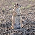
The West Block of the park is located one hour south of Swift Current, and the main visitor reception centre is located in the town of Val Marie. Highlights of the West Block include the Frenchman River Valley, a herd of over 300 plains bison as well as prairie dog colonies. A 16-kilometre (10 mi) wide stretch of land on either side of the Frenchman River is an Important Bird Area of Canada called Grasslands National Park (west) (SK 024). [10] Frenchman Valley Campground offers visitors serviced camping sites, teepee camping, and a cook shelter. Backcountry camping is also available. [11] The West Block is located in Census Division No. 4.

The East Block of the park is located about an hour's drive south of Assiniboia on the south side of the Wood Mountain Hills in Census Division No. 3. The interpretive centre is in the McGowan House at the new Rock Creek Campground and the information centre is at the museum in Wood Mountain Regional Park. [12] The East Block is more of a wilderness area but has views of the badlands of Rock Creek, the Cretaceous–Paleogene boundary, and prairie skies. A one-lane, 11-kilometre (6.8 mi) parkway traverses the Rock Creek Badlands. [13] The East Block contains the Grasslands National Park (east) (SK 023) Important Bird Area. [14]

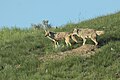
In 2006, plains bison from Elk Island National Park in Alberta were reintroduced to Grasslands. [15] By 2015 the herd had grown from the original 71 animals to over 300. [16] The herd is maintained on a 181 km2 (70 sq mi) section in the park's West Block. On 2 October 2009, in a ceremony at Belza House, the park was declared a dark-sky preserve, [17] and a small population of black-footed ferrets was reintroduced into the prairie dog towns after a 70-year absence. Improved night-lighting practices under the dark-sky agreement ensure that the park remains dark at night, preserving a natural environment for all nocturnal wildlife. [18]

Plants of the park
Mammals of the park
Birds of the park

See also

Related Research Articles

<span class="mw-page-title-main">Great Plains</span> Flat expanse in western North America

The Great Plains, sometimes simply "the Plains", is a broad expanse of flatland in North America. It is located just to the east of the Rocky Mountains, much of it covered in prairie, steppe, and grassland. It is the western part of the Interior Plains, which also include the mixed grass prairie, the tallgrass prairie between the Great Lakes and Appalachian Plateau, and the Taiga Plains and Boreal Plains ecozones in Northern Canada. Great Plains or Western Plains is also used to describe the ecoregion of the Great Plains, or alternatively the western portion of the Great Plains.

<span class="mw-page-title-main">Badlands National Park</span> National park in South Dakota, United States

Badlands National Park is an American national park located in southwestern South Dakota. The park protects 242,756 acres of sharply eroded buttes and pinnacles, along with the largest undisturbed mixed grass prairie in the United States. The National Park Service manages the park, with the South Unit being co-managed with the Oglala Lakota tribe.

<span class="mw-page-title-main">Black-footed ferret</span> Species of carnivore

The black-footed ferret, also known as the American polecat or prairie dog hunter, is a species of mustelid native to central North America.

<span class="mw-page-title-main">Elk Island National Park</span> National park in Alberta, Canada

Elk Island National Park is a national park in Alberta, Canada, that played an important part in the conservation of the Plains bison. The park is administered by the Parks Canada Agency. This "island of conservation" is 35 km (22 mi) east of Edmonton, along the Yellowhead Highway, which goes through the park. It is Canada's eighth smallest in area but largest fully enclosed national park, with an area of 194 km2 (75 sq mi).

<span class="mw-page-title-main">Theodore Roosevelt National Park</span> National park in North Dakota, United States

Theodore Roosevelt National Park is an American national park of the badlands in western North Dakota comprising three geographically separated areas. Honoring U.S. President Theodore Roosevelt, it is the only American national park named directly after a single person.

<span class="mw-page-title-main">Val Marie</span> Village in Saskatchewan, Canada

Val Marie is a village in the Canadian province of Saskatchewan within the Rural Municipality of Val Marie No. 17 and Census Division 4. It is about 30 kilometres from the Canada-United States border.

<span class="mw-page-title-main">Cypress Hills Interprovincial Park</span> Interprovincial park in Western Canada

Cypress Hills Interprovincial Park is a natural park in Canada straddling the Alberta / Saskatchewan boundary and jointly administered by the two provinces. Located south-east of Medicine Hat in the Cypress Hills, it became Canada's first interprovincial park in 1989.

<span class="mw-page-title-main">Custer State Park</span> State park in South Dakota, United States

Custer State Park is a South Dakota State Park and wildlife reserve in the Black Hills of the United States. Located in Custer County, the park is South Dakota's first and largest state park, named after Lieutenant Colonel George Armstrong Custer. The park covers an area of over 71,000 acres (287 km2) of varied terrain including rolling prairie grasslands and rugged mountains.

<span class="mw-page-title-main">Plains bison</span> Subspecies of bison

The Plains bison is one of two subspecies/ecotypes of the American bison, the other being the wood bison. A natural population of Plains bison survives in Yellowstone National Park and multiple smaller reintroduced herds of bison in many places in the United States as well as southern portions of the Canadian Prairies.

<span class="mw-page-title-main">Caprock Canyons State Park and Trailway</span> Protected area in Briscoe County, Texas with 64 mile trail over former railroad right-of-way

Caprock Canyons State Park and Trailway is a Texas state park located along the eastern edge of the Llano Estacado in Briscoe County, Texas, United States, approximately 100 miles (160 km) southeast of Amarillo. The state park opened in 1982 and is 15,314 acres (6,197 ha) in size, making it the third-largest state park in Texas.

<span class="mw-page-title-main">Maple Creek, Saskatchewan</span> Town in Saskatchewan, Canada

Maple Creek is a town in the Cypress Hills of southwest Saskatchewan, Canada. It is surrounded by the Rural Municipality of Maple Creek No. 111. The population was 2,176 at the 2021 Census.

<span class="mw-page-title-main">Wanuskewin Heritage Park</span> Cultural and historical centre of First Nations near Saskatoon, Saskatchewan

Wanuskewin Heritage Park is an archaeological site and non-profit cultural and historical centre of the First Nations just outside the city of Saskatoon, Saskatchewan. The faculty's name comes from the Cree language word ᐋᐧᓇᐢᑫᐃᐧᐣ or wânaskêwin, meaning, "being at peace with oneself". The site is a National Historic Site of Canada due to the importance of its archaeological resources representing nearly 6000 years of the history of the Northern Plains peoples. In 2016, it was announced that Wanuskewin intends to seek UNESCO World Heritage designation, which would make it the first World Heritage Site in Saskatchewan.

Highway 34 designates major roads intended for travel by the public between Highway 13 just to the west of Ogema to the US border. The highway used to connect to Montana Secondary Highway 511 at the Port of Big Beaver, however the port closed in 2011. Saskatchewan's main roadways are located in the central/southern geographical land area of rugged badlands, and rolling prairie and grass land in a western Canadian prairie province. This paved highway along with Red Coat Trail and Outlaw Tail, early Red River cart trails encompassed the Big Muddy Badlands.

<span class="mw-page-title-main">Shortgrass prairie</span> Ecosystem located on the North American Great Plains

The shortgrass prairie is an ecosystem located in the Great Plains of North America. The two most dominant grasses in the shortgrass prairie are blue grama and buffalograss, the two less dominant grasses in the prairie are greasegrass and sideoats grama. The prairie was formerly maintained by grazing pressure of American bison, which is the keystone species. Due to its semiarid climate, the shortgrass prairie receives on average less precipitation than that of the tall and mixed grass prairies to the east.

Carmichael is a special service area within the Rural Municipality of Carmichael No. 109, Saskatchewan, Canada that held village status prior to 2019. The population was 58 at the 2016 Census. Carmichael lies 1 km (1 mi) south of Highway 1 commonly known as the Trans Canada Highway, approximately 158 km (98 mi) east of city of Medicine Hat, Alberta.

<span class="mw-page-title-main">Fauna of Saskatchewan</span>

The Fauna of Saskatchewan include several diverse land and aquatic animal species. From the multiplicity of invertebrates and vertebrates, two have been chosen as symbols of Saskatchewan. Cenozoic vertebrate fossils reveal the geological evolution of the interior plains and its prehistoric biogeography. Today, Saskatchewan's ecosystems range from the sub-arctic tundra of the Canadian Shield in north Saskatchewan to aspen parkland, the Mid-Continental Canadian forests in the centre of the province and grassland prairie. Fauna inhabit areas unique to their own specific and varied breeding, foraging and nesting requirements. With a large land and water area, and small population density, the ecoregions of Saskatchewan provide important habitat for many animals, both endangered and not. Naturalists observing wildlife have enumerated shrinking and growing wildlife populations. They advocate programs and methods to preserve or re-introduce endangered species and identify programs of control for outbreaks of wildlife populations. A broad diversity of wildlife habitats are preserved as parks and reserves protecting the feeding and breeding grounds of protected and indigenous fauna of Saskatchewan.

<span class="mw-page-title-main">Northern Shortgrass Prairie</span> Temperate grasslands, savannas, and shrublands ecoregion of Canada and the United States

The Northern Shortgrass Prairie includes parts of the Canadian provinces of Alberta and Saskatchewan, and the American Great Plains states of Montana, North Dakota, Wyoming, South Dakota and Nebraska. One of 844 terrestrial ecoregions defined by One Earth, the United States Environmental Protection Agency (EPA) further breaks this ecoregion into the Northwestern Glaciated Plains and Northwestern Great Plains.

<span class="mw-page-title-main">American Prairie</span> Nature reserve in Montana, United States

American Prairie is a prairie-based nature reserve in Central Montana, United States, on a mixed grass prairie ecosystem with migration corridors and native wildlife. This wildlife conservation area is being developed as a private project of the American Prairie Foundation (APF). This independent non-profit organization aims to include over 3 million acres (12,000 km2) through a combination of both private and public lands.

<span class="mw-page-title-main">Conservation of American bison</span> Effort to increase bison in North America

The conservation of bison in North America is an ongoing, diverse effort to bring American bison back from the brink of extinction. Plains bison, a subspecies, are a keystone species in the North American Great Plains. Bison are a species of conservation concern in part because they suffered a severe population bottleneck at the end of the 19th century. The near extinction of the species during the 19th century unraveled fundamental ties between bison, grassland ecosystems, and indigenous peoples’ cultures and livelihoods.# English speakers used the word buffalo for this animal when they arrived. Bison was used as the scientific term to distinguish them from the true buffalo. Buffalo is commonly used as it continues to hold cultural significance, particularly for Indigenous people.

Wood Mountain Hills are a hilly plateau in the Canadian province of Saskatchewan. The hills are located in the southern part of the province and are part of the Missouri Coteau, which is part of the Laurentian Divide between the watersheds of the Hudson Bay drainage basin of the Arctic Ocean and the Gulf of Mexico of the Atlantic Ocean. The hills are in a semi-arid region known as Palliser's Triangle in the Great Plains ecoregion of North America.

References

  1. Parks Canada Visitation Records Archived 17 November 2015 at the Wayback Machine Accessed November 17, 2016
  2. Whelan, Piper (3 May 2021). "The struggle to restore native prairie". Canadian Cattlemen. Archived from the original on 20 September 2021. Retrieved 20 September 2021.
  3. "Ferrets, foxes and the fringed orchid: Species that suffer when grasslands are threatened". The Nature of Things: Science, Wildlife and Technology. CBC. Retrieved 12 October 2020.
  4. "Grasslands National Park: Wildlife". Archived from the original on 5 June 2022. Retrieved 5 June 2022.
  5. Camping in Grasslands National Park, Parks Canada, 24 November 2021, archived from the original on 9 February 2013, retrieved 28 September 2012
  6. "Unique Places to visit in Saskatchewan". To Do Canada. 21 July 2023. Retrieved 30 March 2024.
  7. Grasslands National Park of Canada: Human - Land Relationships - Human History, Parks Canada, archived from the original on 10 February 2013, retrieved 13 April 2012
  8. "The Key First Nation, Welcomes Home Bison Herd Back To Treaty 4 Land". TDS News. 1 February 2022. Archived from the original on 17 March 2023. Retrieved 17 March 2023.
  9. "Bison to once again roam lands around Batoche, Sask., after deal inked". CBC News. 20 November 2022. Archived from the original on 21 November 2022.
  10. "Grasslands National Park (west) Val Marie, Saskatchewan". IBA Canada. Archived from the original on 14 October 2023. Retrieved 28 December 2022.
  11. "Grasslands National Park Frenchman Valley Campground". Tourism Saskatchewan. Archived from the original on 27 March 2023. Retrieved 9 July 2022.
  12. "Wood Mountain Regional Park". Wood Mountain. Archived from the original on 5 October 2022. Retrieved 28 December 2022.
  13. "Rock Creek Badlands - Badlands Parkway". Tourism Saskatchewan. Government of Saskatchewan. Archived from the original on 31 October 2022. Retrieved 9 November 2022.
  14. "Grasslands National Park (east) Killdeer, Saskatchewan". IBA Canada. Archived from the original on 9 July 2022. Retrieved 28 December 2022.
  15. "Where buffalo roam", Montreal Gazette , 23 July 2007, archived from the original on 11 April 2014, retrieved 13 April 2012
  16. Bison update, Parks Canada, 10 November 2017, archived from the original on 6 January 2019, retrieved 14 November 2017
  17. "Parks Canada". World Class Astronomy. 29 January 2016. Archived from the original on 13 December 2016. Retrieved 2 October 2016.
  18. Grasslands National Park, Parks Canada, archived from the original on 8 May 2012, retrieved 13 April 2012

Commons-logo.svg Media related to Grasslands National Park at Wikimedia Commons