Regina is the capital city of the Canadian province of Saskatchewan. The city is the second-largest in the province, after Saskatoon, and is a commercial centre for southern Saskatchewan. As of the 2021 census, Regina had a city population of 226,404, and a Metropolitan Area population of 249,217. It is governed by Regina City Council. The city is surrounded by the Rural Municipality of Sherwood No. 159.
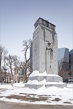
A cenotaph is an empty tomb or a monument erected in honour of a person or group of people whose remains are elsewhere. It can also be the initial tomb for a person who has since been reinterred elsewhere. Although the vast majority of cenotaphs honour individuals, many noted cenotaphs are instead dedicated to the memories of groups of individuals, such as the lost soldiers of a country or of an empire.
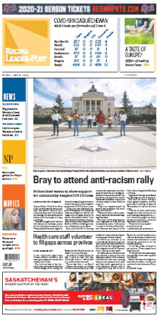
The Regina Leader-Post is the daily newspaper of Regina, Saskatchewan, Canada, and a member of the Postmedia Network.

Government House, Regina, Saskatchewan, Canada, was constructed as a residence for the lieutenant governor of the North-West Territories, whose territorial headquarters were in Regina until the provinces of Saskatchewan and Alberta were created out of the Territories in 1905 and Regina became the capital of Saskatchewan.
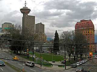
Victory Square is a park in Vancouver, British Columbia, Canada. The square is bordered by West Hastings Street to the northeast, West Pender Street to the southwest, Cambie Street to the southeast, and Hamilton Street to the northwest. The term is also used to refer to the neighbourhood immediately surrounding the square.
Ring Road is a 4 lane controlled access highway in Regina, Saskatchewan, Canada. Ring Road is a partial ring road or beltway that forms a partial circle around Regina, bypasses the city on the north, east, and south sides, with Lewvan Drive and Pasqua Street N functioning as the de facto western leg. East of Pasqua Street, Ring Road continues west as 9th Avenue N, an arterial road. Ring Road has a speed limit of 100 km/h (60 mph) and consists of 13 interchanges.

Many historically significant buildings in Regina, Saskatchewan were lost during the period 1945 through approximately 1970 when the urge to "modernize" overtook developers' and city planners' sense of history and heritage. The old warehouse district to the north of the old CPR tracks was Regina's original commercial raison d'être once Lieutenant-Governor Edgar Dewdney had established the site of his considerable landholdings as the Territorial Capital. 1899 to 1919 Washington Park and 3431 Dewdney Ave building as CPR commercial logistics building, expanded connected with significant conversion of shipping of commercial goods from train to truck and cancellation of passenger service on the railway, the Warehouse District immediately adjacent to the train line has ceased to be exclusively industrial in character. Some areas of the Warehouse District have been transformed into a shopping, entertainment and residential precinct.
Victoria Avenue is one of the main east-west streets in Regina, Saskatchewan, Canada. Victoria Avenue is named in honour of Queen Victoria and crosses Albert Street, in downtown. It is the main eastern entrance into Regina.

Gainsborough is a village in the Canadian province of Saskatchewan within the Rural Municipality of Argyle No. 1 and Census Division No. 1. A farming community, the village is located on Highway 18 in the southeastern corner of Saskatchewan. Gainsborough is approximately 6 km (3.7 mi) from the Manitoba border, and 19 km (12 mi) from the North Dakota, United States border. The first post office was established on April 1, 1884 as the community of Antler. On September 1, 1885, the name of the community changed to Gainsborough, after Gainsborough, Lincolnshire in England, which was the former home of J. J. Sadler, an early settler.

John Street is a Lower City arterial road in Hamilton, Ontario, Canada. Originally it was known as Mountain Road or Ancaster Road. It starts off at the base of Arkledun Avenue, a Mountain-access road in the city, just east of St. Joseph's Hospital, where it is a one-way street going north and tunnels underneath the Hunter Street Railway bridge and continues onward to the city's North End at the waterfront, where it ends at Guise Street East, the site of Pier 9.

Seven neighbourhoods are of considerable note:

King Street is a Lower City arterial road in Hamilton, Ontario, Canada, also known as Highway 8. The western-end starts off beside McMaster University Medical Centre as a two-way street and passes through Westdale. At Paradise Road, King Street switches over to a one-way street (westbound) right through the city's core up to "the Delta", a spot in town where King and Main streets intersect. From the Delta onwards, King Street then switches over to become a two-way street again and ends at Highway 8 in Stoney Creek.
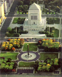
The Indiana World War Memorial Plaza is an urban feature and war memorial located in downtown Indianapolis, Indiana, United States, originally built to honor the veterans of World War I. It was conceived in 1919 as a location for the national headquarters of the American Legion and a memorial to the state's and nation's veterans.

Clarence Square is a small park in downtown Toronto, Ontario, Canada, where Wellington Street West meets Spadina Avenue. It is a relatively quiet and shady park, with many large trees and a spacious grassy terrain. There are several benches and picnic tables scattered throughout and a drinking fountain in the centre.
The timeline of Regina history shows the significant events in the history of Regina, Saskatchewan, Canada.

Knox-Metropolitan United Church stands on Lorne Street at Victoria Avenue across from Victoria Park in downtown Regina, Saskatchewan, Canada. It is the current manifestation of Presbyterian and Methodist congregations that date back to "worship services in both traditions…in 1882."
Albert Street is an arterial road in Regina, Saskatchewan. It is one of the main roads in and out of the downtown area of the city. It is named in honour of Prince Albert, the husband and consort of Queen Victoria, and intersects Victoria Avenue in centre of the city.

Gore Park is a town square or urban park located in downtown Hamilton, Ontario.