
Saskatchewan is a province in western Canada, bordered on the west by Alberta, on the north by the Northwest Territories, on the east by Manitoba, to the northeast by Nunavut, and on the south by the U.S. states of Montana and North Dakota. Saskatchewan and Alberta are the only landlocked provinces of Canada. In 2022, Saskatchewan's population was estimated at 1,205,119. Nearly 10% of Saskatchewan’s total area of 651,900 square kilometres (251,700 sq mi) is fresh water, mostly rivers, reservoirs and lakes.

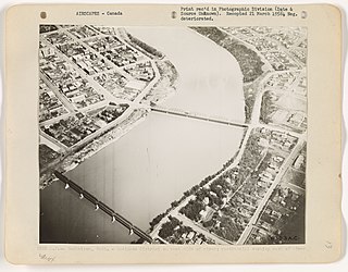
Saskatoon is the largest city in the Canadian province of Saskatchewan. It straddles a bend in the South Saskatchewan River in the central region of the province. It is located along the Trans-Canada Yellowhead Highway, and has served as the cultural and economic hub of central Saskatchewan since its founding in 1882 as a Temperance colony.

Swift Current is the fifth largest city in the Canadian province of Saskatchewan. It is situated along the Trans Canada Highway 170 kilometres (110 mi) west of Moose Jaw, and 218 kilometres (135 mi) east of Medicine Hat, Alberta. Swift Current grew 6.8% between 2011 and 2016, ending up at 16,604 residents. The city is surrounded by the Rural Municipality of Swift Current No. 137.

Rosetown is a town in the Canadian province of Saskatchewan, at the junction of provincial Highway 7 and Highway 4, approximately 115 km southwest of Saskatoon.

SaskTel Centre is an arena located in the Agriplace Industrial Park, Saskatoon, Saskatchewan, Canada. With 15,195 permanent stadium seats, and situated near the city's northern entrance, the facility opened in February 1988 with a seating capacity of around 7,800. It was expanded to 11,330 for the World Junior Hockey Championships in 1990. Additional permanent seating was added in 2008 and 2009. The current capacity is 15,190 for hockey.

Kyle is a town in Lacadena Rural Municipality No. 228, in the province of Saskatchewan, Canada. The town had a population of 423 in the 2006 Census. The village was named for its original settler, Jeremiah Kyle, in 1923. Kyle is 72 kilometres (45 mi) north of Swift Current, and is situated along the remains of the historic Swift Current-Battleford Trail, 201 kilometres (125 mi) south-west of Saskatoon, 320 kilometres (200 mi) west of Regina and 32 kilometres (20 mi) north of Saskatchewan Landing Provincial Park on Highway 4. The Canada Post postal code for Kyle is S0L 1T0.

Wanuskewin Heritage Park is an archaeological site and non-profit cultural and historical centre of the First Nations just outside the city of Saskatoon, Saskatchewan. The faculty's name comes from the Cree language word ᐋᐧᓇᐢᑫᐃᐧᐣ or wânaskêwin, meaning, "being at peace with oneself". The site is a National Historic Site of Canada due to the importance of its archaeological resources representing nearly 6000 years of the history of the Northern Plains peoples. In 2016, it was announced that Wanuskewin intends to seek UNESCO World Heritage designation, which would make it the first World Heritage Site in Saskatchewan.

Whitewood is a town in the Canadian province of Saskatchewan. It is located approximately 175 kilometres (109 mi) east of Regina on the Trans-Canada Highway Sk Hwy 1. It is situated at the crossroads of two major highways systems – the Trans-Canada, which runs east and west, and Sk Hwy 9, which runs north and south from the US border to Hudson Bay, Saskatchewan. Located midway between Brandon, Manitoba and Regina, Whitewood was and continues to be an ideal place to stop and rest.

Highway 11 is a major north-south highway in Saskatchewan, Canada that connects the province's three largest cities: Regina, Saskatoon and Prince Albert. It is a structural pavement major arterial highway which is approximately 391 kilometres (243 mi) long. It is also known as the Louis Riel Trail (LRT) after the 19th century Métis leader. It runs from Highway 1 in Regina until Highway 2 south of Prince Albert. Historically the southern portion between Regina and Saskatoon was Provincial Highway 11, and followed the Dominion Survey lines on the square, and the northern portion between Saskatoon and Prince Albert was Provincial Highway 12.

Highway 5 is a major highway in the Canadian province of Saskatchewan. It begins in downtown Saskatoon and runs eastward to the Manitoba border near Togo, where it becomes Provincial Road 363. The highway is approximately 393 kilometres (244 mi) long. Between the early 1900s (decade) and 1976, Provincial Highway 5 was a trans-provincial highway travelling approximately 630 kilometres (390 mi) in length. At this time it started at the Alberta border in Lloydminster and traveled east to the Manitoba border.
The history of Saskatoon began with the first permanent non-indigenous settlement of Saskatoon, Saskatchewan, Canada, in 1883 when Toronto Methodists, wanting to escape the liquor trade in that city, decided to set up a "dry" community in the rapidly growing prairie region. As of 1882 this area was a part of the provisional district named Saskatchewan, North-West Territories (NWT). Their organization, the Temperance Colonization Society, first examined this area in 1882 and found that it would make an excellent location to found their community based on the ideals of the temperance movement. The settlers, led by John Neilson Lake, arrived on the site of what is now Saskatoon by traveling by railway from Ontario to Moose Jaw, Assiniboia, NWT, and then completing the final leg via horse-drawn cart. The plan for the Temperance Colony soon failed as the group was unable to obtain a large block of land within the community. Nonetheless, John Lake is commonly identified as the founder of Saskatoon; a public school, a park and two streets are named after him.

Broadview is a community in Saskatchewan along the #1 highway, the Trans Canada Highway, 155 kilometres (96 mi) east of Regina. The local economy is based mainly on agriculture. It is also the administrative headquarters of the Rural Municipality of Elcapo No. 154
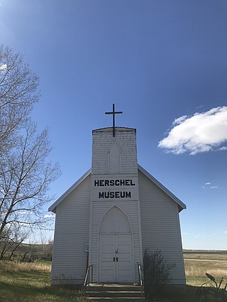
Herschel is a special service area in the Canadian province of Saskatchewan. It is the seat of the Rural Municipality of Mountain View No. 318 and held village status prior to December 31, 2006. The population was 30 people in 2016. The community is located 37 km northwest of the town of Rosetown at the intersection of Highway 31 and Highway 656, along a now abandoned section of the Kerrobert-Rosetown Canadian Pacific Railway line. Herschel is the home of the Ancient Echoes Interpretive Centre. The Vancouver-based backpack manufacturer Herschel Supply Co., founded by Lyndon and Jamie Cormack in 2009, adopted the name of Herschel, the town where three generations of their family grew up.
Transportation in Saskatchewan is the movement of people and goods from one place to another within the province. Transportation in Saskatchewan includes an infrastructure system of roads, highways, freeways, airports, ferries, pipelines, trails, waterways, and railway systems serving a population of approximately 1,098,352 inhabitants year-round.
There are numerous heritages and cultural attractions in the province of Saskatchewan. Museums, dinosaur digs, aboriginal cultural and heritage sites, art galleries, professional sport venues, spas, handcraft, antique and tea shops, agricultural tours, theatre and archaeological sites comprise over 600 varied Saskatchewan institutions.
The Rural Municipality of Mountain View No. 318 is a rural municipality (RM) in the Canadian province of Saskatchewan within Census Division No. 12 and SARM Division No. 6.

Archaeology in Saskatchewan, Canada, is supported by professional and amateur interest, privately funded and not-for-profit organizations, and governmental and citizen co-operation with the primary incentive to encourage archaeological awareness and interest in the heritage that defines the province to this date. The landscape of Saskatchewan hosts substantial prehistoric and historic sites.
The 190 mile long (300 km) Swift Current-Battleford Trail was an important late-19th century transportation and communications link between settlements of Swift Current and Battleford - the result of a brisk trade, in buffalo bones which resulted heavy traffic between the two regions. Because of the large volume of Red River cart traffic, the ruts created during this period are still visible today. The historical significance of this resulted in The Battleford Trail becoming a provincial heritage site in 1982.
Throughout its history, between 3,200 and 6,000 students died while attending the Canadian Indian residential school system. The exact number remains unknown due to incomplete records. Comparatively few cemeteries associated with residential schools are explicitly referenced in surviving documents, however the age and duration of the schools suggests that most had a cemetery associated with them. Most cemeteries were unregistered, and as such the locations of many burial sites of residential school children have been lost. The Truth and Reconciliation Commission of Canada has called for "the ongoing identification, documentation, maintenance, commemoration, and protection of residential school cemeteries or other sites at which residential school children were buried."
