Pike Lake Provincial Park is a recreational park located approximately 32 kilometres (20 mi) south-west of Saskatoon, Saskatchewan. Established in 1960, it is operated under the Government of Saskatchewan's Ministry of Parks, Culture, and Sport. It is located at the southern terminus of Highway 60 on the shore of Pike Lake, an oxbow lake created by the South Saskatchewan River. The Pike Lake area is part of the aspen parkland biome and trees found around the park include aspen, ash, and birch.

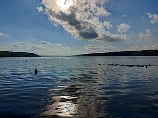
The Fishing Lakes, also called the Calling Lakes or the Qu'Appelle Lakes, are a chain of four lakes in the Qu'Appelle Valley cottage country about 40 miles (64 km) to the north-east of Regina in the Canadian province of Saskatchewan. The lakes are in a region called the Prairie Pothole Region of North America, which extends throughout three Canadian provinces and five U.S. states. It is also within Palliser's Triangle and the Great Plains ecoregion. The Fishing Lakes all follow the course of the Qu'Appelle River, which flows from the west to the east and is part of the Hudson Bay drainage basin. The lakes sit in the deep-cut Qu'Appelle Valley that was formed about 14,000 years ago during the last ice age. Meltwater from the glaciers carved out the valley and as water levels rose and fell, alluvium was left in the wake. These piles of alluvium are what created the separations between the lakes.

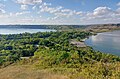
Last Mountain Lake, also known as Long Lake, is a prairie lake formed from glaciation 11,000 years ago. It is located in south central Saskatchewan, Canada, about 40 kilometres (25 mi) north-west of the city of Regina. It flows into the Qu'Appelle River via Last Mountain Creek, which flows past Craven. It is approximately 93 km (58 mi) long, and 3 km (1.9 mi) across at its widest point. It is the largest naturally occurring body of water in southern Saskatchewan. Only Lake Diefenbaker, which is man-made, is larger. The lake is a popular resort area for residents of south-eastern Saskatchewan.

Blackstrap Provincial Park is a provincial park in the Canadian province of Saskatchewan in the RM of Dundurn No. 314. Prior to the park's establishment in 1986, it was a provincial recreation site. The park runs along the eastern shore of Blackstrap Lake and consists of a conservation area, campground, beaches, Mount Blackstrap, cross country ski trails, biking and hiking trails, and several picnicking areas. It is about 8.5 kilometres (5.3 mi) east of the town of Dundurn and accessed via Highway 211. Mount Blackstrap is a man-made mountain built as a ski hill for the 1971 Canada Winter Games. It continued to operate as a ski hill until 2007.

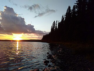
Narrow Hills Provincial Park is a northern boreal forest provincial recreational park in the Canadian province of Saskatchewan. It is located in a hilly plateau called the Cub Hills and contains several recreational facilities and over 25 accessible lakes within its boundaries. The geographical features of the park, including the lakes, valleys, and lowlands were formed over 10,000 years ago during the last ice age. The town of Smeaton is the closest community and it is located 70 kilometres (43 mi) to the south.

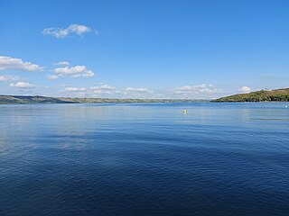
Katepwa Lake is a recreational lake in the Qu’appelle Valley in the Canadian province of Saskatchewan. The lake's name likely originated from the Cree word Kahtapwao, which means "What is calling?" Katepwa Lake is eastern most and farthest downstream of four lakes along the Qu'Appelle River known as the Fishing Lakes. Highway 56 runs along the eastern and southern shore and Highway 619 runs along the south-eastern shore.
Porcupine Hills Provincial Park is the newest provincial park in the Canadian Province of Saskatchewan. It was created in 2018 through the amalgamation of five pre-existing provincial recreation sites south-east of the town of Hudson Bay. The park is in the Porcupine Provincial Forest in the Porcupine Hills, which is a geographical feature in eastern Saskatchewan and western Manitoba. The hills are part of a range of hills called the Manitoba Escarpment.
Pasqua Lake is a lake along the course of the Qu'Appelle River in the Canadian province of Saskatchewan. Pasqua Lake was named after Chief Joseph Pasqua who formed what became the Pasqua First Nation. It is one of four lakes that make up the Fishing Lakes, which are all in the Qu'Appelle Valley. The Qu'Appelle Valley was formed about 14,000 years ago during the last ice age as meltwater from the glaciers carved out the valley. As water levels rose and fell, alluvium was left in the wake. These piles of alluvium are what created the separations between the lakes.
Echo Lake is a lake along the course of the Qu'Appelle River in the Canadian province of Saskatchewan. Echo Lake is so named because of the echo heard by the First Nations while paddling on the lake. It is one of four lakes that make up the Fishing Lakes. Pasqua Lake is upstream and Mission Lake is downstream. The lake can be accessed by Highway 56 and Highway 210. In 1942, a 4-metre (13 ft) high dam was built on the Qu'Appelle River at Echo Lake's outflow to control the lake's water levels. In the summer of 2024, Saskatchewan's Water Security Agency begun "interim repairs" on Echo Lake Dam to "improve safety and extend the dam's life until a replacement can be completed".
Mission Lake, also known as Lebret Lake, is a lake in the Canadian province of Saskatchewan. It is one of four lakes in the Qu'Appelle Valley known as the Fishing Lakes. Echo Lake is upstream and Katepwa Lake is downstream. The lake was named Mission after the Catholic mission at Lebret. Highways 22 35, and 56 provide access to the lake.
Marean Lake is a spring fed lake in the Canadian province of Saskatchewan. The lake is located at the western end of Greenwater Lake Provincial Park in the Porcupine Provincial Forest on the Porcupine Hills. The RM of Bjorkdale No. 426 surrounds the lake and it is accessed off Highway 679.
Hudson Bay Regional Park is a regional park in the Canadian province of Saskatchewan. It is located on the south side of the town of Hudson Bay in the RM of Hudson Bay No. 394 along the shores of the Red Deer River. The park is the site of a North West Company fur trading fort called Fort Red Deer River that was built in 1790. About 14 kilometres (8.7 mi) downstream, near Erwood, was a Hudson's Bay Company trading post that was built in 1757.
Pierce Lake is a lake in Meadow Lake Provincial Park in the Canadian Province of Saskatchewan. It is situated along the course of the Cold River in the boreal forest ecozone of Canada. Upstream along Cold River from Pierce Lake is Cold Lake and downstream are Lepine Lake and Lac des Îles. Pierce Lake and Cold River are in the Beaver River watershed, which is part of the Churchill River and Hudson Bay drainage basin.
Kimball Lake is a lake in Meadow Lake Provincial Park in the Canadian Province of Saskatchewan in the boreal forest ecozone of Canada. The lake is located near the centre of the park, north of the Waterhen River and Little Raspberry Lake and south of First Mustus Lake. Rusty and Greig Lakes are to the east. Several small streams feed into the lake and the outflow is at the southern shore, which feeds into the Waterhen River, a tributary of Beaver River. The Beaver River, in turn, flows north into Lac Île-à-la-Crosse and the Churchill River, a major tributary in the Hudson Bay drainage basin.
Matheson Lake is a lake in Meadow Lake Provincial Park in the Canadian Province of Saskatchewan in the boreal forest ecozone of Canada. The lake is located near the centre of the park, north of the Waterhen River, west of Vivian Lake and south of Peitahigan Lake. Several small streams feed into the lake and the outflow is at the southern shore, which feeds into the Waterhen River, a tributary of Beaver River. The Beaver River, in turn, flows north into Lac Île-à-la-Crosse and the Churchill River, a major tributary in the Hudson Bay drainage basin.
Lost Echo Lake is a lake in the east-central part of the Canadian province of Saskatchewan in Narrow Hills Provincial Park. It is situated in a glacier-formed valley in the Cub Hills and the boreal forest ecozone of Canada. It is south of Summit Lake and is accessed from secondary roads that branch off of Highway 913. While there are no communities nor settlements on the lake, there is the Lost Echo Wilderness Campsite on the western shore.
Lower Fishing Lake is a lake in the east-central part of the Canadian province of Saskatchewan in Narrow Hills Provincial Park. It is situated in the Cub Hills and the boreal forest ecozone of Canada. The lake is accessed from Highway 920, which connects to Hanson Lake Road and Highway 120. The Fishing Lakes Fire of 1977 burned much of the region upstream and around the lake and now the area is now dominated by jack pine, which is a tree species that is well adapted fire burned forests.
Piprell Lake is a lake in the Canadian province of Saskatchewan in the boreal forest ecozone of Canada. The lake is located in the Northern Saskatchewan Administration District, just south of the geographical centre of Saskatchewan in the Cub Hills. It is west of the western boundary of Narrow Hills Provincial Park and south-east of Clarence-Steepbank Lakes Provincial Park Piprell Lake Recreation Site and Rainbow Lodge are situated at the northern end of the lake and its amenities are accessed from Highway 913.
The Cub Hills are a hilly plateau located south-east of the geographical centre of the Canadian province of Saskatchewan. The hills are in the boreal forest ecozone of Canada and the landforms of the hills were shaped more than 10,000 years ago during last ice age. Throughout the Cub Hills, there are dozens of lakes and rivers and several parks. The Cubs Hills are 150 km (93 mi) north-east of Prince Albert and are in the Northern Saskatchewan Administration District and Census Division #18. Several highways criss-cross the plateau to provide access to the various parks and other amenities.
McBride Lake is a lake in the east-central part of the Canadian province of Saskatchewan in the boreal forest ecozone of Canada. It is a narrow lake that runs west to east along the course of the Pepaw River known for its fishing and recreational opportunities. It is situated in the Porcupine Hills and within Saskatchewan's Porcupine Provincial Forest. There is a provincial park and a small subdivision along the lake's shore and access is from Highway 983. Eldredge Lake is upstream from McBride Lake along the course of the Pepaw River and Pepaw Lake is downstream. Swallow lake is to the north and a short stream flows from Swallow Lake into the eastern end of McBride Lake.