Echo Lake | |
---|---|
Location | Saskatchewan |
Group | Fishing Lakes |
Coordinates | 50°48′0″N103°51′2″W / 50.80000°N 103.85056°W |
Primary inflows | Qu'Appelle River at Sioux Crossing |
Primary outflows | Qu'Appelle River |
Basin countries | Canada |
Max. length | 5 km (3.1 mi) |
Max. width | 1.7 km (1.1 mi) |
Surface area | 1,296.3 ha (3,203 acres) |
Average depth | 9.8 m (32 ft) |
Max. depth | 22 m (72 ft) |
Water volume | 242,000 dam3 (196,000 acre⋅ft) |
Shore length1 | 16 km (9.9 mi) |
Surface elevation | 474 m (1,555 ft) |
Settlements | Fort Qu'Appelle |
1 Shore length is not a well-defined measure. |
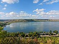
Echo Lake [1] is a lake along the course of the Qu'Appelle River in the Canadian province of Saskatchewan. Echo Lake is so named because of the echo heard by the First Nations while paddling on the lake. It is one of four lakes that make up the Fishing Lakes. [2] [3] Pasqua Lake is upstream and Mission Lake is downstream. The lake can be accessed by Highway 56 and Highway 210. [4] In 1942, a 4-metre (13 ft) high dam was built on the Qu'Appelle River at Echo Lake's outflow to control the lake's water levels. [5]
Echo Lake, as well as the other three Fishing Lakes, are all in the Qu'Appelle Valley, which was formed about 14,000 years ago during the last ice age. Meltwater from the glaciers carved out the valley and as water levels rose and fell, alluvium was left in the wake. These piles of alluvium are what created the separations between the lakes. [6]
Echo Lake is located in the RM of North Qu'Appelle No. 187. The town of Fort Qu'Appelle is the largest community, not just on Echo Lake, but all of the Fishing Lakes. It is located at the eastern end of the lake, between Echo and Mission Lakes. Echo Lake is home to two resort villages; B-Say-Tah is on a point of land along the southern shore and Fort San is located opposite B-Say-Tah on the northern shore. Standing Buffalo Indian reserve is located at the north-western corner of the lake and occupies the northern half of the isthmus that separated Echo Lake from Pasqua Lake.
Echo Valley Provincial Park is located at the western end of the lake, south of Standing Buffalo and west of B-Say-Tah. The park features camping, hiking, and access to both Pasqua and Echo Lakes for boating, swimming, and fishing. The beach at the park is called Echo Beach. Other beaches along the lake's shore include B-Say-Tah Point Beach and Fort Qu’Appelle Valley Centre beach. [7]
Echo Lake Bible Camp [8] is located west of Fort San along Highway 57.
The Saskatchewan Fish Hatchery (formally Fort Qu’Appelle Fish Culture Station), originally established in 1913, is located along Highway 210, 5 kilometres (3.1 mi) west of Fort Qu'Appelle and 2 kilometres (1.2 mi) east of Echo Valley Provincial Park, on the west side of B-Say-Tah. The hatchery produces between 40 and 50 million total fish annually, including both exotic and native species, which includes 500,000 trout and 20 million walleye. The hatchery is responsible for stocking over 200 bodies of water in Saskatchewan, including up to 150 lakes. It is the only aquaculture facility in Saskatchewan that produces fish for public angling opportunities. [9] [10]
In November 2014, the administration of the Saskatchewan Fish Hatchery was transferred from the Government of Saskatchewan to the Saskatchewan Wildlife Federation. The operating costs are funded by Saskatchewan’s Fish and Wildlife Development Fund (FWDF). [11] [12]
Fish commonly found in the lake include northern pike, walleye, and yellow perch. [13]
The Qu'Appelle River is a river in the Canadian provinces of Saskatchewan and Manitoba that flows 430 kilometres (270 mi) east from Lake Diefenbaker in south-western Saskatchewan to join the Assiniboine River in Manitoba, just south of Lake of the Prairies, near the village of St. Lazare. It is in a region called the Prairie Pothole Region of North America, which extends throughout three Canadian provinces and five U.S. states. It is also within Palliser's Triangle and the Great Plains ecoregion.
Fort Qu'Appelle is a town in the Canadian province of Saskatchewan located in the Qu'Appelle River valley 70 km (43 mi) north-east of Regina, between Echo and Mission Lakes of the Fishing Lakes. It is not to be confused with the once-significant nearby town of Qu'Appelle. It was originally established in 1864 as a Hudson's Bay Company trading post. Fort Qu'Appelle, with its 1,919 residents in 2006, is at the junction of Highway 35, Highway 10, Highway 22, Highway 56, and Highway 215. The 1897 Hudson's Bay Company store, 1911 Grand Trunk Pacific Railway station, Fort Qu'Appelle Sanatorium, and the Treaty 4 Governance Centre in the shape of a teepee are all landmarks of this community. Additionally, the Noel Pinay sculpture of a man praying commemorates a burial ground, is a life-sized statue in a park beside Segwun Avenue.
The Fishing Lakes, also called the Calling Lakes or the Qu'Appelle Lakes, are a chain of four lakes in the Qu'Appelle Valley cottage country about 40 miles (64 km) to the north-east of Regina in the Canadian province of Saskatchewan. The lakes are in a region called the Prairie Pothole Region of North America, which extends throughout three Canadian provinces and five U.S. states. It is also within Palliser's Triangle and the Great Plains ecoregion. The Fishing Lakes all follow the course of the Qu'Appelle River, which flows from the west to the east and is part of the Hudson Bay drainage basin. The lakes sit in the deep-cut Qu'Appelle Valley that was formed about 14,000 years ago during the last ice age. Meltwater from the glaciers carved out the valley and as water levels rose and fell, alluvium was left in the wake. These piles of alluvium are what created the separations between the lakes.
Division No. 6 is one of eighteen census divisions in the province of Saskatchewan, Canada, as defined by Statistics Canada. It is located in the south-central part of the province. The most populous community in this division is Regina, the provincial capital.
Highway 210 is a provincial highway in the Canadian province of Saskatchewan. Saskatchewan's 200-series highways primarily service its recreational areas. It runs from Highway 10 to Highway 35 in Fort Qu'Appelle. The highway intersects Highway 56 and passes through Echo Valley Provincial Park, B-Say-Tah, and provides access to Pasqua and Echo Lakes of the Fishing Lakes. It is about 21 kilometres (13 mi) long.
The Rural Municipality of North Qu'Appelle No. 187 is a rural municipality (RM) in the Canadian province of Saskatchewan within Census Division No. 6 and SARM Division No. 1. It is located in the south-east portion of the province.
Highway 35 is a paved undivided provincial highway in the Canadian province of Saskatchewan.. It runs from the US Border near Port of Oungre to a dead end near the north shore of Tobin Lake. Saskatchewan Highway 35 (SK Hwy 35) is about 569 kilometres (354 mi) long. The CanAm Highway comprises Saskatchewan Highways 35, SK Hwy 39, SK Hwy 6, SK Hwy 3, SK Hwy 2 and U.S. Route 85. 74.6 kilometres (46.4 mi) of SK Hwy 35 contribute to the CanAm Highway between Port of Oungre on the Canada – United States border and Weyburn. Mudslides, and spring flooding were huge road building and maintenance problems around Nipawin as well as along the southern portion of the route named the Greater Yellow Grass Marsh. Over 20 early dams were built until the problem was addressed with the Rafferty-Alameda Project on the Souris River and the construction of the Qu'Appelle River Dam which have helped to eliminate washed out roads and flooded communities. The highway through the homesteading community followed the Dominion Land Survey on the square until reaching the Saskatchewan River at Nipawin. The completion of the combined railway and traffic bridge over the Saskatchewan River at Nipawin in the late 1920s retired the ferry and basket crossing for traffic north of Nipawin. The E.B. Campbell Dam built in 1963 northeast of Nipawin created Tobin Lake, and Codette Lake was formed with the construction of the Francois-Finlay Hydroelectric dam at Nipawin. The railway/traffic bridge that formed part of Highway 35 was the only crossing utilized at Nipawin until a new traffic bridge was constructed in 1974. The new bridge then became part of the combined Highway 35 and 55 until the highway parts just east of White Fox. Highway 35 then continued north along the west side of Tobin Lake. The railway/traffic bridge continues to be utilized for one lane vehicle traffic controlled by traffic lights, and continues as the "old highway 35" on the west side of the river until it joins with the current Highway 35/55.
Last Mountain Lake, also known as Long Lake, is a prairie lake formed from glaciation 11,000 years ago. It is located in south central Saskatchewan, Canada, about 40 kilometres (25 mi) north-west of the city of Regina. It flows into the Qu'Appelle River via Last Mountain Creek, which flows past Craven. It is approximately 93 km (58 mi) long, and 3 km (1.9 mi) wide at its widest point. It is the largest naturally occurring body of water in southern Saskatchewan. Only Lake Diefenbaker, which is man-made, is larger. The lake is a popular resort area for residents of south-eastern Saskatchewan.
Buffalo Pound Lake is a eutrophic prairie lake in Saskatchewan, Canada, formed from glaciation about 10,000 years ago, on the Qu'Appelle River approximately 28 kilometres (17 mi) north of Moose Jaw and 11 kilometres (6.8 mi) north-east of Tuxford. The lake gets its name from the method used by First Nations people to capture the bison using the natural topography as corrals or buffalo pounds. Bison, once numbering more than 60 million on the prairies but almost extinct by 1900, were reintroduced into the area in 1972.
B-Say-Tah is a resort village in the Canadian province of Saskatchewan within Census Division No. 6. It is on the shores of Echo Lake of the Fishing Lakes in the Rural Municipality of North Qu'Appelle No. 187. It is approximately 70 kilometres (43 mi) north-east of Regina and 5 kilometres (3.1 mi) west of Fort Qu'Appelle on Highway 210. Echo Valley Provincial Park is 2 kilometres (1.2 mi) to the west.
Katepwa is a resort village in the Canadian province of Saskatchewan within Census Division No. 6. It is on the eastern and southern shores of Katepwa Lake in the Rural Municipality of Abernethy No. 186. The name Katepwa likely comes from the Cree word Kahtapwao meaning "What is calling?" The name was given to the last in the chain of four lakes, Katepwa Lake. Legend has it that spirits inhabited the shores of the lake and First Nation people would hear voices on the lake.
Echo Valley Provincial Park is a provincial park in the Canadian province of Saskatchewan, located west of the town of Fort Qu'Appelle in the Qu'Appelle Valley between Echo Lake and Pasqua Lake in the RM of North Qu'Appelle No. 187. The three main roads to access the park are Highways 210, 56, and 727.
Crooked Lake is a recreational lake located in the south-eastern region of the Canadian province of Saskatchewan. It is part of a chain of lakes in the Qu'Appelle Valley and, like many of the other lakes in the valley, there's a dam at the eastern end that controls water levels.
Katepwa Lake is a recreational lake in the Qu’appelle Valley in the Canadian province of Saskatchewan. The lake's name likely originated from the Cree word Kahtapwao, which means "What is calling?" Katepwa Lake is eastern most and farthest downstream of four lakes along the Qu'Appelle River known as the Fishing Lakes. Highway 56 runs along the eastern and southern shore and Highway 619 runs along the south-eastern shore.
Pasqua Lake is a lake along the course of the Qu'Appelle River in the Canadian province of Saskatchewan. Pasqua Lake was named after Chief Joseph Pasqua who formed what became the Pasqua First Nation. It is one of four lakes that make up the Fishing Lakes, which are all in the Qu'Appelle Valley. The Qu'Appelle Valley was formed about 14,000 years ago during the last ice age as meltwater from the glaciers carved out the valley. As water levels rose and fell, alluvium was left in the wake. These piles of alluvium are what created the separations between the lakes.
Mission Lake, also known as Lebret Lake, is a lake in the Canadian province of Saskatchewan. It is one of four lakes in the Qu'Appelle Valley known as the Fishing Lakes. Echo Lake is upstream and Katepwa Lake is downstream. The lake was named Mission after the Catholic mission at Lebret. Highways 22 35, and 56 provide access to the lake.
Craven Dam is at the confluence of the Qu'Appelle River and Last Mountain Creek and immediately east of the village of Craven on the Qu'Appelle River at LSD SW 24-20-21 W2. It is in the Canadian province of Saskatchewan in the RM of Longlaketon No. 219. The dam does not create a reservoir as its purpose is to regulate water flow along the Qu'Appelle River. The dam is operated by the Saskatchewan Water Security Agency and can be accessed on the north side by Highway 99.
Douglas Provincial Park is a provincial park in the Canadian province of Saskatchewan. Established in 1973, it is named after Tommy Douglas, the seventh premier of Saskatchewan and father of Canada's first single-payer, universal health care programme. The park is located along the Gordon McKenzie Arm of Lake Diefenbaker and at the Qu'Appelle River Dam, which is the source of the Qu'Appelle River. The closest community is Elbow and access to the park is from Highway 19.
Jumbo Lake is a lake in the Canadian province of Saskatchewan in the transition zone between parkland and boreal forest. It is also known as Big Jumbo Lake to differentiate it from adjoining Little Jumbo Lake. Big and Little Jumbo Lakes make up the heart of Makwa Lake Provincial Park and are part of several inter-connected lakes that include Makwa Lake and Upper Makwa Lake. The southern half of the lake is within Makwa Lake Provincial Park and the northern half is within Makwa Lake 129B Indian reserve. Access to both lakes is from Highway 699.
Makwa Lake Provincial Park is a recreational provincial park in the west-central region of the Canadian province of Saskatchewan in the transition zone between parkland and boreal forest. The park was established in 1986 and is centred around the lakes of Big Jumbo, Little Jumbo, and Makwa. Prior to its establishment, the park was a provincial recreation site. The main entrance to Makwa Lake Park is at the south-east corner of Makwa Lake about 3 kilometres (1.9 mi) west of the village of Loon Lake. Access is from Highway 699.