Mission Lake

Last updated

Mission Lake
Mission Lake Sk.jpg
Mission Lake
Canada Saskatchewan relief location map.jpg
Red pog.svg
Mission Lake
Location in Saskatchewan
Canada relief map 2.svg
Red pog.svg
Mission Lake
Mission Lake (Canada)
Location Saskatchewan
Coordinates 50°45′33″N103°44′29″W / 50.75917°N 103.74139°W / 50.75917; -103.74139
Primary inflows Qu'Appelle River
Primary outflows Qu'Appelle River
Basin  countriesCanada
Max. length5 km (3.1 mi)
Max. width1.6 km (0.99 mi)
Surface area769 ha (1,900 acres)
Average depth8.3 m (27 ft)
Max. depth16.8 m (55 ft)
Water volume62,937 dam3 (51,024 acre⋅ft)
Shore length114.5 km (9.0 mi)
Surface elevation459 m (1,506 ft)
Settlements Lebret
1 Shore length is not a well-defined measure.

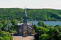
Mission Lake, [1] also known as Lebret Lake, is a lake in the Canadian province of Saskatchewan. It is one of four lakes in the Qu'Appelle Valley known as the Fishing Lakes. [2] Echo Lake is upstream and Katepwa Lake is downstream. The lake was named Mission after the Catholic mission at Lebret. Highways 22 35, and 56 provide access to the lake. [3]

Contents

Mission Lake, as well as the other three Fishing Lakes, are all in the Qu'Appelle Valley, which was formed about 14,000 years ago during the last ice age. Meltwater from the glaciers carved out the valley and as water levels rose and fell, alluvium was left in the wake. These piles of alluvium are what created the separations between the lakes. [4]

The Qu'Appelle River is both the primary inflow and out flow. The river enters the lake at the west end, near the town of Fort Qu'Appelle, and exits the lake at the south-east end. Echo Creek [5] is a small creek that rises to the south-west near McLean and enters the lake at the south-west corner.

Communities

Mission Lake is located in the RM of North Qu'Appelle No. 187. At the western end is the town of Fort Qu'Appelle, which sits between Mission and Echo Lakes. The village of Lebret [6] and the adjoining Wa-pii-moos-toosis Indian Reserve are on the northern shore along Highway 56. The Qu'Appelle Indian Residential School [7] was located on the Wa-pii-moos-toosis Indian Reserve.

Recreation

Mission Ridge Winter Park [8] is a ski resort in the Qu'Appelle River valley near the south-west area of the lake. Syrian Beach is on the southern shore, near the east end and directly across the lake from Lebret. Lebret Provincial Recreation Site [9] is at the village of Lebret. It is a small park at Haffner Beach with a picnic area and boat launch.

Fish species

Fish commonly found in Mission Lake include walleye, perch, and northern pike.

See also

Related Research Articles

<span class="mw-page-title-main">Qu'Appelle River</span> River in Western Canada

The Qu'Appelle River is a river in the Canadian provinces of Saskatchewan and Manitoba that flows 430 kilometres (270 mi) east from Lake Diefenbaker in south-western Saskatchewan to join the Assiniboine River in Manitoba, just south of Lake of the Prairies, near the village of St. Lazare. It is in a region called the Prairie Pothole Region of North America, which extends throughout three Canadian provinces and five U.S. states. It is also within Palliser's Triangle and the Great Plains ecoregion.

<span class="mw-page-title-main">Fort Qu'Appelle</span> Town in Saskatchewan, Canada

Fort Qu'Appelle is a town in Canadian province of Saskatchewan located in the Qu'Appelle River valley 70 km (43 mi) north-east of Regina, between Echo and Mission Lakes of the Fishing Lakes. It is not to be confused with the once-significant nearby town of Qu'Appelle. It was originally established in 1864 as a Hudson's Bay Company trading post. Fort Qu'Appelle, with its 1,919 residents in 2006, is at the junction of Highway 35, Highway 10, Highway 22, Highway 56, and Highway 215. The 1897 Hudson's Bay Company store, 1911 Grand Trunk Pacific Railway station, Fort Qu'Appelle Sanatorium, and the Treaty 4 Governance Centre in the shape of a teepee are all landmarks of this community. Additionally, the Noel Pinay sculpture of a man praying commemorates a burial ground, is a life-sized statue in a park beside Segwun Avenue.

<span class="mw-page-title-main">Fishing Lakes</span> Chain of lakes in Saskatchewan

The Fishing Lakes, also called the Calling Lakes or the Qu'Appelle Lakes, are a chain of four lakes in the Qu'Appelle Valley cottage country about 40 miles (64 km) to the north-east of Regina in the Canadian province of Saskatchewan. The lakes are in a region called the Prairie Pothole Region of North America, which extends throughout three Canadian provinces and five U.S. states. It is also within Palliser's Triangle and the Great Plains ecoregion. The Fishing Lakes all follow the course of the Qu'Appelle River, which flows from the west to the east and is part of the Hudson Bay drainage basin. The lakes sit in the deep-cut Qu'Appelle Valley that was formed about 14,000 years ago during the last ice age. Meltwater from the glaciers carved out the valley and as water levels rose and fell, alluvium was left in the wake. These piles of alluvium are what created the separations between the lakes.

<span class="mw-page-title-main">Pheasant Creek</span> River in Saskatchewan, Canada

Pheasant Creek is a creek that runs along the bottom of one of the many coulees that branch off the Qu'Appelle Valley and empties into the Qu'Appelle River in southern Saskatchewan. The creek starts between the communities of Ituna and Jasmin, meanders south of the village of Abernethy and north of the village of Sintaluta. The Qu'Appelle River drainage basin is divided into two sections, the Upper and lower watersheds. Pheasant Creek is a tributary of the lower watershed.

<span class="mw-page-title-main">Division No. 6, Saskatchewan</span> Census division of Saskatchewan, Canada

Division No. 6 is one of eighteen census divisions in the province of Saskatchewan, Canada, as defined by Statistics Canada. It is located in the south-central part of the province. The most populous community in this division is Regina, the provincial capital.

<span class="mw-page-title-main">Last Mountain Lake</span> Lake in Saskatchewan, Canada

Last Mountain Lake, also known as Long Lake, is a prairie lake formed from glaciation 11,000 years ago. It is located in south central Saskatchewan, Canada, about 40 kilometres (25 mi) north-west of the city of Regina. It flows into the Qu'Appelle River via Last Mountain Creek, which flows past Craven. It is approximately 93 km (58 mi) long, and 3 km (1.9 mi) wide at its widest point. It is the largest naturally occurring body of water in southern Saskatchewan. Only Lake Diefenbaker, which is man-made, is larger. The lake is a popular resort area for residents of south-eastern Saskatchewan.

<span class="mw-page-title-main">Wascana Creek</span> River in Saskatchewan, Canada

Wascana Creek is a river in the Canadian province of Saskatchewan. It is a tributary of the Qu'Appelle River.

<span class="mw-page-title-main">Echo Valley Provincial Park</span> Provincial park in Saskatchewan, Canada

Echo Valley Provincial Park is a provincial park in the Canadian province of Saskatchewan, located west of the town of Fort Qu'Appelle in the Qu'Appelle Valley between Echo Lake and Pasqua Lake in the RM of North Qu'Appelle No. 187. The three main roads to access the park are Highways 210, 56, and 727.

<span class="mw-page-title-main">Katepwa Lake</span> Lake in Saskatchewan, Canada

Katepwa Lake is a recreational lake in the Qu’appelle Valley in the Canadian province of Saskatchewan. The lake's name likely originated from the Cree word Kahtapwao, which means "What is calling?" Katepwa Lake is eastern most and farthest downstream of four lakes along the Qu'Appelle River known as the Fishing Lakes. Highway 56 runs along the eastern and southern shore and Highway 619 runs along the south-eastern shore.

<span class="mw-page-title-main">Star Blanket Cree Nation</span>

Star Blanket Cree Nation is a First Nations band government in Saskatchewan, Canada. Its reserves are in the Fort Qu'Appelle area. The Star Blanket Cree Nation is one of the bands covered by Treaty 4.

<span class="mw-page-title-main">Wa-pii-moos-toosis 83A</span> Indian Reserve in Saskatchewan

Wa-pii-moos-toosis 83A is an Indian reserve of the Star Blanket Cree Nation in Saskatchewan. In 2016, its Community Well-Being index was calculated at 61 of 100, compared to 58.4 for the average First Nations community and 77.5 for the average non-Indigenous community. The name of the locality means "White Calf".

<span class="mw-page-title-main">Pipestone Creek (Saskatchewan)</span> River in central North America

Pipestone Creek is a river in the Souris River watershed. Its flow begins in southeastern Saskatchewan, just south of the town of Grenfell and travels in a southeastern direction into Manitoba in the Westman Region where it empties into Oak Lake through the Oak Lake Marsh.

<span class="mw-page-title-main">Moose Mountain Creek</span> River in southern Saskatchewan, Canada

Moose Mountain Creek is a river in the Canadian province of Saskatchewan. Its source is the Chapleau Lakes near Montmartre and it is a tributary of the Souris River, which, in turn, is a tributary of the Assiniboine River. The whole system is part of the Red River watershed, which is part of the Hudson Bay drainage basin and in a region called the Prairie Pothole Region of North America, which extends throughout three Canadian provinces and five U.S. states. It is also within Palliser's Triangle and the Great Plains ecoregion.

<span class="mw-page-title-main">Last Mountain Creek</span> River in Saskatchewan, Canada

Last Mountain Creek is a river in south-central Saskatchewan. It is a tributary of the Qu'Appelle River in a region called the Prairie Pothole Region of North America, which extends throughout three Canadian provinces and five U.S. states. It is also within Palliser's Triangle and the Great Plains ecoregion.

<span class="mw-page-title-main">Lanigan Creek</span> River in Saskatchewan, Canada

Lanigan Creek is a river in the Canadian province of Saskatchewan. It is located in the south central part of the province in a region called the Prairie Pothole Region of North America, which extends throughout three Canadian provinces and five U.S. states. It is also within Palliser's Triangle and the Great Plains ecoregion.

<span class="mw-page-title-main">Pasqua Lake</span> Lake in Saskatchewan, Canada

Pasqua Lake is a lake along the course of the Qu'Appelle River in the Canadian province of Saskatchewan. Pasqua Lake was named after Chief Joseph Pasqua who formed what became the Pasqua First Nation. It is one of four lakes that make up the Fishing Lakes, which are all in the Qu'Appelle Valley. The Qu'Appelle Valley was formed about 14,000 years ago during the last ice age as meltwater from the glaciers carved out the valley. As water levels rose and fell, alluvium was left in the wake. These piles of alluvium are what created the separations between the lakes.

<span class="mw-page-title-main">Echo Lake (Saskatchewan)</span> Lake in Saskatchewan, Canada

Echo Lake is a lake along the course of the Qu'Appelle River in the Canadian province of Saskatchewan. Echo Lake is so named because of the echo heard by the First Nations while paddling on the lake. It is one of four lakes that make up the Fishing Lakes. Pasqua Lake is upstream and Mission Lake is downstream. The lake can be accessed by Highway 56 and Highway 210. In 1942, a 4 m (13 ft) high dam was built on the Qu'Appelle River at Echo Lake's outflow to control the lake's water levels.

Hudson Bay Regional Park is a regional park in the Canadian province of Saskatchewan. It is located on the south side of the town of Hudson Bay in the RM of Hudson Bay No. 394 along the shores of the Red Deer River. The park is the site of a North West Company fur trading fort called Fort Red Deer River that was built in 1790. About 14 kilometres (8.7 mi) downstream, near Erwood, was a Hudson's Bay Company trading post that was built in 1757.

Lost Echo Lake is a lake in the east-central part of the Canadian province of Saskatchewan in Narrow Hills Provincial Park. It is situated in a glacier-formed valley in the Cub Hills and the boreal forest ecozone of Canada. It is located south of Summit Lake and is accessed from secondary roads that branch off of Highway 913. While there are no communities or settlements on the lake, there is the Lost Echo Wilderness Campsite on the western shore.

<span class="mw-page-title-main">Caribou Creek</span> River in Saskatchewan

Caribou Creek is a river in the east-central part of the Canadian province of Saskatchewan. The river's source is in a hilly plateau called Cub Hills, near the western boundary of Narrow Hills Provincial Park. The river heads south following a glacier-carved valley through the Cub Hills en route to its mouth at Lower Fishing Lake. The entire course of the river is in the boreal forest ecozone of Canada. Caribou Creek is a tributary of Stewart Creek, which flows south and into the east-flowing Torch River. Torch River is a tributary of the Saskatchewan River as it flows into the Saskatchewan River Delta. Much of the upper watershed was burned in 1977 in what is known as the Fishing Lakes Fire and is now dominated by a forest of jack pine.

References

  1. Government of Canada, Natural Resources Canada. "Place names - Mission Lake". www4.rncan.gc.ca.
  2. "Lower Qu'Appelle River Watershed | Water Security Agency". Wsask.ca. Retrieved 29 November 2021.
  3. "Qu'Appelle Lakes, Saskatchewan, Canada". Lake Lubbers. Lakelubbers LLC. Retrieved 20 November 2021.
  4. "Qu'Appelle Valley Geolog". Cmste.uregina.ca. 8 October 2004. Retrieved 29 November 2021.
  5. Government of Canada, Natural Resources Canada. "Place names - Echo Creek". www4.rncan.gc.ca.
  6. McLennan, David. "Lebret". The encyclopedia of Saskatchewan. Government of Saskatchewan. Retrieved 20 November 2021.
  7. "Lebret (Qu'Appelle)". nctr. University of Manitoba. Retrieved 20 November 2021.
  8. "Mission Ridge". Mission Ridge. Mission Ridge Winter Park. Retrieved 20 November 2021.
  9. "Lebret Recreation Site". Canadian Geographical Names Database. Government of Canada. Retrieved 13 August 2023.