The Northwest Territories is a federal territory of Canada. At a land area of approximately 1,144,000 km2 (442,000 sq mi) and a 2016 census population of 41,790, it is the second-largest and the most populous of the three territories in Northern Canada. Its estimated population as of 2021 is 45,515. Yellowknife is the capital, most populous community, and only city in the territory; its population was 19,569 as of the 2016 census. It became the territorial capital in 1967, following recommendations by the Carrothers Commission.

The four corners is a quadripoint near 60° N 102° W where four Canadian provinces or territories meet. These are the provinces of Manitoba and Saskatchewan and the territories of the Northwest Territories and Nunavut. It came into being with the creation of Nunavut on April 1, 1999.

Kasba Lake is a lake in the northern Canadian wilderness. The majority of the lake lies within the Northwest Territories, but a small section is in Nunavut. The lake is close to Canada's four corners. A seasonal fishing lodge is open to tourists each summer.
Baker Lake is a hamlet in the Kivalliq Region, in Nunavut on mainland Canada. Located 320 km (200 mi) inland from Hudson Bay, it is near the nation's geographical centre, and is notable for being Nunavut's sole inland community. The hamlet is located at the mouth of the Thelon River on the shore of Baker Lake. The community was given its English name in 1761 from Captain William Christopher who named it after Sir William Baker, the 11th Governor of the Hudson's Bay Company.

Auyuittuq National Park is a national park located on Baffin Island's Cumberland Peninsula, in the Qikiqtaaluk Region of Nunavut, the largest political subdivision of Canada. The park was initially known as Baffin Island National Park when it was established in 1972, but the name was changed in 1976 to its current name to better reflect the region and its history. It features many terrains of Arctic wilderness, such as fjords, glaciers, and ice fields. Although Auyuittuq was established in 1972 as a national park reserve, it was upgraded to a full national park in 2000.

Whale Cove, is a hamlet located 74 km (46 mi) south southwest of Rankin Inlet, 145 km (90 mi) northeast of Arviat, in Kivalliq Region, Nunavut, Canada, on the western shore of Hudson Bay.

Ennadai Lake is a lake in Kivalliq Region, Nunavut, Canada. It is 52 mi (84 km) long, and 3 to 14 mi wide. It is drained to the north by the Kazan River. A 615 km section of the Kazan River from the outlet of Ennadai Lake to Baker Lake, was designated as a part of the Canadian Heritage Rivers System in 1990.

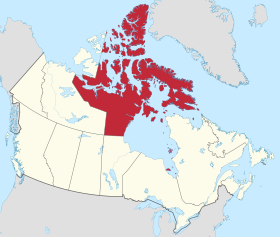
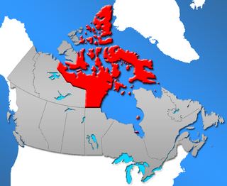
Nunavut is the largest and northernmost territory of Canada. It was separated officially from the Northwest Territories on April 1, 1999, via the Nunavut Act and the Nunavut Land Claims Agreement Act, which provided this territory to the Inuit for independent government. The boundaries had been drawn in 1993. The creation of Nunavut resulted in the first major change to Canada's political map in half a century since the province of Newfoundland was admitted in 1949.

The Northwest Territories is a territory in Northern Canada, specifically in Northwestern Canada between Yukon Territory and Nunavut including part of Victoria Island, Melville Island, and other islands on the western Arctic Archipelago. Originally a much wider territory enclosing most of central and northern Canada, the Northwest Territories was created in 1870 from the Hudson's Bay Company's holdings that were sold to Canada from 1869-1870. In addition, Alberta and Saskatchewan were formed from the territory in 1905. In 1999, it was divided again: the eastern portion became the new territory of Nunavut. Yellowknife stands as its largest city and capital. It has a population of 42,800 and has an area of 532,643 sq mi (1,379,540 km2). The current territory lies west of Nunavut, north of latitude 60° north, and east of Yukon.
Nunavut is a territory of Canada. It has a land area of 1,877,787.62 km2 (725,017.85 sq mi). In the 2016 census the population was 35,944, up 12.7% from the 2011 census figure of 31,906. In 2016, 30,135 people identified themselves as Inuit, 190 as North American Indian (0.5%), 165 Métis (0.5%) and 5,025 as non-aboriginal (14.0%).
Henik Lake is located in the Kivalliq Region of Nunavut, Canada. The lake is made up of two lakes, North Henik Lake and South Henik Lake with a narrows separating them. Of the two, North Henik Lake is the smaller with an area of 245 km2 (95 sq mi), while South Henik Lake has an area of 513 km2 (198 sq mi).
Kaminak Lake is a lake in Kivalliq Region, Nunavut, Canada. The sub-Arctic lake is one of eleven lakes of the Ferguson River system which ultimately flow into the northwestern Hudson Bay. The abandoned outpost of Tavani is 60 mi (97 km) to the east.
Tahiryuaq, formerly Ferguson Lake, is located on southern Victoria Island in the Kitikmeot Region of Nunavut, in northern Canada. It drains westward into Iqaluktuuq which is a segment of the Ekalluk River, 5 mi (8.0 km) from the northeastern side of Wellington Bay (Ekaloktok), on Dease Strait, Arctic Ocean Ferguson Lake was the namesake of Constable Ferguson, a Royal Canadian Mounted Police member, but is now known by the original name of Tahiryuaq
Ferguson Lake is a lake in Kivalliq Region, Nunavut, Canada. It is located 150 km (93 mi) north of the tree line, midway between Yathkyed Lake and Qamanirjuaq Lake. The lake's outflow is to the east into the Ferguson River, which flows eastward through several lakes, emptying into northwestern Hudson Bay between Rankin Inlet and Whale Cove. The closest community is Baker Lake, 160 km (99 mi) to the north.
Qamanirjuaq Lake formerly Kaminuriak Lake, pronunciation: ka-min-YOO-ree-ak; meaning: "huge lake adjoining a river at both ends", is a lake in the Kivalliq Region, Nunavut, Canada. It is the first of several named lakes on the eastward flow of the Ferguson River through the eastern barrenlands. The lake is located about 2 km (1 mi) downstream from Ferguson Lake, and adjacent upstream to Parker Lake South. The Ferguson River passes through a series of rapids before entering the western arm of Qamanirjuaq Lake.
Padlei is a former community in the Kivalliq Region of Nunavut, Canada. It is located on the mainland on the north shore of Kinga (Kingarvalik) Lake at the juncture of the Maguse River. Whale Cove is to the east, while the Henik Lakes are to the southwest.

Tulemalu Lake is a lake in Kivalliq Region, Nunavut, Canada.

Napaktulik Lake formerly Takiyuak Lake or Takijuq Lake is the eighth largest lake in Nunavut, Canada. It is located 173 km (107 mi) south of Kugluktuk and is the source of the Hood River.