Pasqua Lake

Last updated

Pasqua Lake
Pasqua Lake 02.jpg
Pasqua Lake
Canada Saskatchewan relief location map.jpg
Red pog.svg
Pasqua Lake
Location in Saskatchewan
Canada relief map 2.svg
Red pog.svg
Pasqua Lake
Pasqua Lake (Canada)
Location Saskatchewan
Coordinates 50°46′30″N103°59′33″W / 50.77500°N 103.99250°W / 50.77500; -103.99250
Primary inflows Qu'Appelle River
Primary outflows Qu'Appelle River at Sioux Crossing
Catchment area Hudson Bay drainage basin
Basin  countriesCanada
Max. length16.1 km (10.0 mi)
Max. width1.6 km (0.99 mi)
Surface area3,110.2 ha (7,685 acres)
Average depth5.8 m (19 ft)
Max. depth18.3 m (60 ft)
Water volume120,932 dam3 (98,041 acre⋅ft)
Shore length140 km (25 mi)
Surface elevation475 m (1,558 ft)
Settlements Pasqua Lake
1 Shore length is not a well-defined measure.

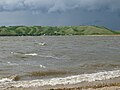
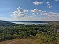
Pasqua Lake [1] is a lake along the course of the Qu'Appelle River in the Canadian province of Saskatchewan. Pasqua Lake was named after Chief Joseph Pasqua who formed what became the Pasqua First Nation. It is one of four lakes that make up the Fishing Lakes, [2] which are all in the Qu'Appelle Valley. The Qu'Appelle Valley was formed about 14,000 years ago during the last ice age as meltwater from the glaciers carved out the valley. As water levels rose and fell, alluvium was left in the wake. These piles of alluvium are what created the separations between the lakes. [3]

Contents

Description

Pasqua Lake is the farthest west and upstream of the four Fishing Lakes. The Qu'Appelle River enters the lake at the far western end and exits the lake at the eastern end through Sioux Crossing. Sioux Crossing is a short channel cut through the isthmus that separates Pasqua from Echo Lake. [4] While the Qu'Appelle River is the primary inflow for the lake, other smaller creeks flow into the lake from the numerous coulees lining the lake's shore. Jumping Deer Creek is the only other named inflow and it flows into the lake at the north-east corner of the lake through the Pasqua Indian Reserve near Sioux Crossing. [5]

Highways 210 and 727 provide access to the lake.

Communities

Along most of the northern shore of Pasqua Lake is the RM of North Qu'Appelle No. 187 and along most of the southern shore is the Pasqua Indian Reserve. [6] The Standing Buffalo Indian reserve [7] is at the north-east corner of the lake, on the north side of the Sioux Crossing. Echo Valley Provincial Park [8] is at the south-east corner of the lake, on the south side of Sioux Crossing. At the south-west end of the lake is the Muscowpetung Indian reserve. [9] The hamlet of Pasqua Lake [10] is the only community outside the Indian reserves on the lake.

Recreation

Pasqua Lake has four boat launches, two of which are at Echo Valley Provincial Park. The lake is great for fishing and the most commonly caught fish are northern pike, walleye, and yellow perch. Along the northern shore of the lake, just east of Pasqua, is Camp Lutherland, [11] which is a Christian camp available for church groups, family gatherings, and other events.

See also

Related Research Articles

<span class="mw-page-title-main">Fishing Lakes</span> Chain of lakes in Saskatchewan, Canada

The Fishing Lakes, also called the Calling Lakes or the Qu'Appelle Lakes, are a chain of four lakes in the Qu'Appelle Valley cottage country about 40 miles (64 km) to the north-east of Regina in the Canadian province of Saskatchewan. The lakes are in a region called the Prairie Pothole Region of North America, which extends throughout three Canadian provinces and five U.S. states. It is also within Palliser's Triangle and the Great Plains ecoregion. The Fishing Lakes all follow the course of the Qu'Appelle River, which flows from the west to the east and is part of the Hudson Bay drainage basin. The lakes sit in the deep-cut Qu'Appelle Valley that was formed about 14,000 years ago during the last ice age. Meltwater from the glaciers carved out the valley and as water levels rose and fell, alluvium was left in the wake. These piles of alluvium are what created the separations between the lakes.

<span class="mw-page-title-main">Division No. 6, Saskatchewan</span> Census division of Saskatchewan, Canada

Division No. 6 is one of eighteen census divisions in the province of Saskatchewan, Canada, as defined by Statistics Canada. It is located in the south-central part of the province. The most populous community in this division is Regina, the provincial capital.

<span class="mw-page-title-main">Rural Municipality of North Qu'Appelle No. 187</span> Rural Municipality in Saskatchewan, Canada

The Rural Municipality of North Qu'Appelle No. 187 is a rural municipality (RM) in the Canadian province of Saskatchewan within Census Division No. 6 and SARM Division No. 1. It is located in the south-east portion of the province.

<span class="mw-page-title-main">Last Mountain Lake</span> Lake in Saskatchewan, Canada

Last Mountain Lake, also known as Long Lake, is a prairie lake formed from glaciation 11,000 years ago. It is located in south central Saskatchewan, Canada, about 40 kilometres (25 mi) north-west of the city of Regina. It flows into the Qu'Appelle River via Last Mountain Creek, which flows past Craven. It is approximately 93 km (58 mi) long, and 3 km (1.9 mi) wide at its widest point. It is the largest naturally occurring body of water in southern Saskatchewan. Only Lake Diefenbaker, which is man-made, is larger. The lake is a popular resort area for residents of south-eastern Saskatchewan.

<span class="mw-page-title-main">Manitou Lake (Saskatchewan)</span> Salt lake in Saskatchewan, Canada

Manitou Lake is a salt lake located mostly in the RM of Manitou Lake No. 422 in the Canadian province of Saskatchewan, about 10 kilometres (6.2 mi) east of the provincial border with Alberta. The eastern shore of the lake is in the RM of Hillsdale No. 440. Manitou Lake is located in a region called the Prairie Pothole Region of North America, which extends throughout three Canadian provinces and five U.S. states. It is also within Palliser's Triangle and the Great Plains ecoregion. Manitou Lake is part of an Important Bird Area (IBA) of Canada that covers 699.66 km2 (270.14 sq mi) of land and serval neighbouring lakes.

<span class="mw-page-title-main">Narrow Hills Provincial Park</span> Provincial park in Saskatchewan, Canada

Narrow Hills Provincial Park is a northern boreal forest provincial recreational park in the Canadian province of Saskatchewan. It is located in a hilly plateau called the Cub Hills and contains several recreational facilities and over 25 accessible lakes within its boundaries. The geographical features of the park, including the lakes, valleys, and lowlands were formed over 10,000 years ago during the last ice age. The town of Smeaton is the closest community and it is located 70 kilometres (43 mi) to the south.

<span class="mw-page-title-main">Boundary Dam Reservoir</span> Lake in Saskatchewan, Canada

Boundary Dam Reservoir is a man-made lake in the south-east corner of the Canadian province of Saskatchewan. It is in census division 1, in the RM of Estevan. The closest city is Estevan, which is about 5.5 kilometres (3.4 mi) downstream. There are no towns or villages along the lake's shore but there are two subdivisions and a regional park. The subdivisions, which are in the RM of Estevan, are called Sunset Bay and Lakewood. The primary inflow and outflow for the reservoir is Long Creek. There is a 10-kilometre long diversion channel that goes to McDonald Lake that can take excess water in either direction.

<span class="mw-page-title-main">Echo Valley Provincial Park</span> Provincial park in Saskatchewan, Canada

Echo Valley Provincial Park is a provincial park in the Canadian province of Saskatchewan, located west of the town of Fort Qu'Appelle in the Qu'Appelle Valley between Echo Lake and Pasqua Lake in the RM of North Qu'Appelle No. 187. The three main roads to access the park are Highways 210, 56, and 727.

<span class="mw-page-title-main">Katepwa Lake</span> Lake in Saskatchewan, Canada

Katepwa Lake is a recreational lake in the Qu’appelle Valley in the Canadian province of Saskatchewan. The lake's name likely originated from the Cree word Kahtapwao, which means "What is calling?" Katepwa Lake is eastern most and farthest downstream of four lakes along the Qu'Appelle River known as the Fishing Lakes. Highway 56 runs along the eastern and southern shore and Highway 619 runs along the south-eastern shore.

Moose Mountain Upland, Moose Mountain Uplands, or commonly Moose Mountain, is a hilly plateau located in the south-east corner of the Canadian province of Saskatchewan, that covers an area of about 13,000 km2 (5,000 sq mi). The upland rises about 200 m (660 ft) above the broad, flat prairie which is about 600 m (2,000 ft) above sea level. The highest peak is "Moose Mountain" at 830 m (2,720 ft) above sea level. The area was named Moose Mountain because of the large number of moose that lived in the area. When it was originally used by fur traders, Métis, and the Indigenous peoples, the plateau was called Montagne a la Bosse, which is French for "The Mountain of The Bump or Knob."

<span class="mw-page-title-main">Last Mountain House Provincial Park</span> Former HBC trading post and current provincial park in Saskatchewan, Canada

Last Mountain House Provincial Park is a provincial park in the Canadian province of Saskatchewan in the RM of Longlaketon. The park is located on the southern end on the eastern shore of Last Mountain Lake, the largest natural lake in southern Saskatchewan.

<span class="mw-page-title-main">Echo Lake (Saskatchewan)</span> Lake in Saskatchewan, Canada

Echo Lake is a lake along the course of the Qu'Appelle River in the Canadian province of Saskatchewan. Echo Lake is so named because of the echo heard by the First Nations while paddling on the lake. It is one of four lakes that make up the Fishing Lakes. Pasqua Lake is upstream and Mission Lake is downstream. The lake can be accessed by Highway 56 and Highway 210. In 1942, a 4 m (13 ft) high dam was built on the Qu'Appelle River at Echo Lake's outflow to control the lake's water levels.

<span class="mw-page-title-main">Mission Lake</span> Lake in Saskatchewan, Canada

Mission Lake, also known as Lebret Lake, is a lake in the Canadian province of Saskatchewan. It is one of four lakes in the Qu'Appelle Valley known as the Fishing Lakes. Echo Lake is upstream and Katepwa Lake is downstream. The lake was named Mission after the Catholic mission at Lebret. Highways 22 35, and 56 provide access to the lake.

Marean Lake is a spring fed lake in the Canadian province of Saskatchewan. The lake is located at the western end of Greenwater Lake Provincial Park in the Porcupine Provincial Forest on the Porcupine Hills. The RM of Bjorkdale No. 426 surrounds the lake and it is accessed off Highway 679.

Hudson Bay Regional Park is a regional park in the Canadian province of Saskatchewan. It is located on the south side of the town of Hudson Bay in the RM of Hudson Bay No. 394 along the shores of the Red Deer River. The park is the site of a North West Company fur trading fort called Fort Red Deer River that was built in 1790. About 14 kilometres (8.7 mi) downstream, near Erwood, was a Hudson's Bay Company trading post that was built in 1757.

Eyebrow Lake is a man-made marshy lake that parallels the Qu'Appelle River in the southern region of the Canadian province of Saskatchewan. Located in the RM of Huron No. 223, it is the first lake in a series of lakes along the Qu'Appelle River after Qu'Appelle River Dam and Lake Diefenbaker. The next lake downstream is Buffalo Pound Lake. The closest community is the village of Tugaske and while there are no public recreation sites at the lake, it can be accessed by Highway 627. The lake gets its name from the nearby Eyebrow Hills, which are shaped like an eyebrow. The nearby town of Eyebrow and RM of Eyebrow No. 193 are also named after these hills.

First Mustus Lake is a lake in Meadow Lake Provincial Park in the Canadian Province of Saskatchewan in the boreal forest ecozone of Canada. The lake is the first of four lakes in a row named Mustus in the Rusty Creek watershed. The other lakes are Second, Third, and Fourth Mustus. Rusty Creek and the lakes are part of the Waterhen River drainage basin. The Waterhen River is a tributary of the Beaver River, which flows north into Lac Île-à-la-Crosse and the Churchill River, a major tributary in the Hudson Bay drainage basin. Highway 224 provides access to both First and Second Mustus Lakes.

Lost Echo Lake is a lake in the east-central part of the Canadian province of Saskatchewan in Narrow Hills Provincial Park. It is situated in a glacier-formed valley in the Cub Hills and the boreal forest ecozone of Canada. It is located south of Summit Lake and is accessed from secondary roads that branch off of Highway 913. While there are no communities or settlements on the lake, there is the Lost Echo Wilderness Campsite on the western shore.

<span class="mw-page-title-main">Caribou Creek</span> River in Saskatchewan

Caribou Creek is a river in the east-central part of the Canadian province of Saskatchewan. The river's source is in a hilly plateau called Cub Hills, near the western boundary of Narrow Hills Provincial Park. The river heads south following a glacier-carved valley through the Cub Hills en route to its mouth at Lower Fishing Lake. The entire course of the river is in the boreal forest ecozone of Canada. Caribou Creek is a tributary of Stewart Creek, which flows south and into the east-flowing Torch River. Torch River is a tributary of the Saskatchewan River as it flows into the Saskatchewan River Delta. Much of the upper watershed was burned in 1977 in what is known as the Fishing Lakes Fire and is now dominated by a forest of jack pine.

Woody River is a river in the Canadian provinces of Manitoba and Saskatchewan. The river's source is in the Porcupine Hills and Porcupine Provincial Forest of eastern Saskatchewan. From there it flows south through boreal forest and then east through Boreal Plains in the Parkland Region of Manitoba en route to Swan Lake. The river parallels the Swan River for much of its route as it travels through Swan River Valley between Duck Mountain and Porcupine Hills of the Manitoba Escarpment. Bowsman is the only notable community along the course of Woody River. Several highways cross it, including Saskatchewan's Highway 980, Manitoba's Roads 588, 587, 366, 268, and Manitoba's Highway 10.

References

  1. Government of Canada, Natural Resources Canada. "Place names - Pasqua Lake". www4.rncan.gc.ca.
  2. "Lower Qu'Appelle River Watershed".
  3. "Qu'Appelle Valley Geolog".
  4. "Boating". RM of North Qu'Appelle No. 187. RM NORTH QU'APPELLE. Retrieved 15 November 2021.
  5. "Qu'Appelle Lakes, Saskatchewan, Canada Vacation Info - LakeLubbers".
  6. "Census Profile, 2016 Census". statcan. Government of Canada. 8 February 2017. Retrieved 19 November 2021.
  7. "Census Profile, 2016 Census". statcan. Government of Canada. 8 February 2017. Retrieved 19 November 2021.
  8. "Echo Valley Provincial Park". tourism Saskatchewan. Saskatchewan Parks. Retrieved 19 November 2021.
  9. "Census Profile, 2016 Census". stat can. Government of Canada. 8 February 2017. Retrieved 19 November 2021.
  10. Government of Canada, Natural Resources Canada. "Place names - Pasqua Lake". www4.rncan.gc.ca.
  11. "Camp Lutherland". Camp Lutherland. Camp Lutherland. Retrieved 15 November 2021.