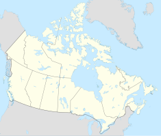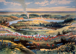
The North-West Rebellion, also known as the North-West Resistance, was an armed resistance movement by the Métis under Louis Riel and an associated uprising by Cree and Assiniboine of the District of Saskatchewan, North-West Territories, against the Canadian government. Many Métis felt that Canada was not protecting their rights, their land, and their survival as a distinct people. Fighting broke out in late March, and the conflict ended in June. About 91 people were killed in the fighting that occurred that spring before the conflict ended with the capture of Batoche in May 1885.

Fort Calgary was a North-West Mounted Police outpost at the confluence of the Bow and Elbow rivers in present-day Calgary, Alberta, Canada. Originally named Fort Brisebois, after the outpost's first commander, the outpost was renamed Fort Calgary in June 1876.

James Morrow Walsh was a North-West Mounted Police (NWMP) officer and the first commissioner of Yukon.

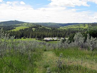
Wood Mountain Regional Park is a conservation and recreation area in its natural state set aside as a regional park in the south-western region of the Canadian province of Saskatchewan. The park is set in the semi-arid Palliser's Triangle in an upland area called Wood Mountain Hills. It is in the Rural Municipality of Old Post No. 43, 8 kilometres (5.0 mi) south of the village of Wood Mountain along Highway 18.

Writing-on-Stone Provincial Park is located about 100 kilometres (60 mi) southeast of Lethbridge, Alberta, Canada, or 44 kilometres (30 mi) east of the community of Milk River, and straddles the Milk River itself. It is one of the largest areas of protected prairie in the Alberta park system, and serves as both a nature preserve and protection for many First Nations (indigenous) rock carvings and paintings. The park is sacred to the Blackfoot and many other aboriginal tribes.

Maple Creek is a town in the Cypress Hills of southwest Saskatchewan, Canada. It is surrounded by the Rural Municipality of Maple Creek No. 111. The population was 2,176 at the 2021 Census.

Fort Carlton was a Hudson's Bay Company fur trading post from 1795 until 1885. It was located along the North Saskatchewan River not far from Duck Lake, in what is now the Canadian province of Saskatchewan. The fort was rebuilt by the government of Saskatchewan as a feature of a provincial historic park and can be visited today. It is about 65 kilometres (40 mi) north of Saskatoon.
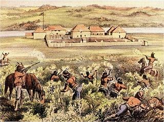
Fort Pitt Provincial Park is a provincial park in the Canadian province of Saskatchewan. Fort Pitt was built in 1829 by the Hudson's Bay Company (HBC) and was a trading post on the North Saskatchewan River in Rupert's Land. It was built at the direction of Chief Factor John Rowand, previously of Fort Edmonton, to trade for bison hides, meat and pemmican. Pemmican, dried buffalo meat, was required as provisions for HBC's northern trading posts.

Highway 5 is a major highway in the Canadian province of Saskatchewan. It begins in downtown Saskatoon and runs eastward to the Manitoba border near Togo, where it becomes Provincial Road 363. The highway is approximately 393 kilometres (244 mi) long. Between the early 1900s (decade) and 1976, Provincial Highway 5 was a trans-provincial highway travelling approximately 630 kilometres (390 mi) in length. At this time it started at the Alberta border in Lloydminster and traveled east to the Manitoba border.

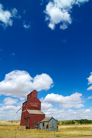
Highway 13 is a highway in the Canadian province of Saskatchewan. It runs from the Alberta border until it transitions into Highway 2 at the Manitoba border near Antler. Highway 13 is about 676 km (420 mi.) long. Highway 13 passes through Shaunavon, Assiniboia, Weyburn, Redvers and Carlyle. It is also referred to as the Red Coat Trail, as much of its length follows the route of the original historic path. A majority of the route between Wauchope and Govenlock going through the Palliser's Triangle is also referred to as the Ghost Town Trail.
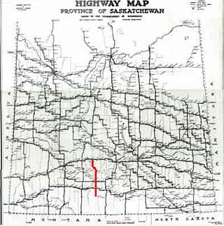
Highway 58 is a provincial highway in the Canadian province of Saskatchewan that handles approximately 100 vehicles per day. The highway runs from Highway 18 about 3 kilometres (1.9 mi) west of Fir Mountain north until Highway 1 / Highway 19 at Chaplin in the south-central region of the province. There are multiplexes of 1.6 kilometres (1.0 mi) with Highway 13, 300 metres (980 ft) with Highway 43, and 4.9 kilometres (3.0 mi) with Highway 363. The section from its southern terminus north to Shamrock is paved while north of Shamrock to Chaplin is gravel. The highway is about 132 kilometres (82 mi) long.

Carlyle is a town in the province of Saskatchewan, Canada. Carlyle is the largest town servicing the far south-eastern corner of Saskatchewan and as a result, has become the economic and services centre of the region. Estevan and Weyburn are the closest cities and both are a little over 100 kilometres away. Regina, the provincial capital, lies 200 km to the north-west.

The Red Coat Trail is a 1,300-kilometre (810 mi) route that approximates the path taken in 1874 by the North-West Mounted Police in their March West from Fort Dufferin to Fort Whoop-Up.

Broadview is a town in Saskatchewan along Highway 1, the Trans-Canada Highway, about 155 kilometres (96 mi) east of Regina. The local economy is based mainly on agriculture. It is also the administrative headquarters of the Rural Municipality of Elcapo No. 154
Fort Walsh is a National Historic Site of Canada that was a North-West Mounted Police (NWMP) fort. Administered by Parks Canada, it forms a constituent part of Cypress Hills Interprovincial Park.
Wood Mountain is a village in the Canadian province of Saskatchewan within the Rural Municipality of Old Post No. 43 and Census Division No. 3. Its name is derived from the Red River Métis words "montagne de bois", due to the abundance of poplar trees in the otherwise barren region. Highway 18 and Highway 358 intersect south of the community.

Jean-Louis Légaré was a French-Canadian trader and one of the founding members of Willow Bunch, Saskatchewan.
The Wood Mountain First Nation is a Lakota First Nations band government in southern Saskatchewan, Canada. Led across the border by Sitting Bull, they are the only organized Lakota nation in Canada. Their reserve is located at Wood Mountain 160, near Grasslands National Park, although most members reside elsewhere.
Wood River is a river in the Canadian province of Saskatchewan. It has its source in the Wood Mountain Hills of south-western Saskatchewan and flows in a north-easterly direction to its mouth at Old Wives Lake. Old Wives Lake is a salt water lake with no outflow. As a result, the drainage basin of Wood River is an endorheic one. Along the course of the river, there are several parks, historical sites, and small towns.
Wood Mountain Hills are a hilly plateau in the Canadian province of Saskatchewan. The hills are located in the southern part of the province and are part of the Missouri Coteau, which is part of the Laurentian Divide between the watersheds of the Hudson Bay drainage basin of the Arctic Ocean and the Gulf of Mexico of the Atlantic Ocean. The hills are in a semi-arid region known as Palliser's Triangle in the Great Plains ecoregion of North America.