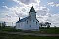
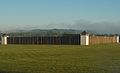
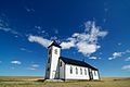
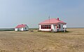
Name Address Coordinates Government recognition (CRHP № ) Image St. Paul's Bergheim Evangelical Lutheran Church Aberdeen No. 373 SK 52°12′08″N 106°24′54″W / 52.2022°N 106.415°W / 52.2022; -106.415 (St. Paul's Bergheim Evangelical Lutheran Church ) Aberdeen No. 373 municipality (5563 ) Upload Photo Foster School Abernethy No. 186 SK 50°47′00″N 103°24′04″W / 50.7833°N 103.401°W / 50.7833; -103.401 (Foster School ) Abernethy No. 186 municipality (1961 ) Upload Photo Kenlis Church Abernethy No. 186 SK 50°39′03″N 103°26′49″W / 50.6508°N 103.447°W / 50.6508; -103.447 (Kenlis Church ) Abernethy No. 186 municipality (1954 ) Little Stone Presbyterian Church Abernethy No. 186 SK 50°44′23″N 103°28′55″W / 50.7396°N 103.482°W / 50.7396; -103.482 (Little Stone Presbyterian Church ) Abernethy No. 186 municipality (2214 ) Upload Photo Hoosier United Church Antelope Park No. 322 SK 51°37′33″N 109°44′28″W / 51.6259°N 109.741°W / 51.6259; -109.741 (Hoosier United Church ) Antelope Park No. 322 municipality (4088 ) Upload Photo Pasquia Palaeontological Site, Jordon River Arborfield No. 456 SK 53°10′19″N 103°31′19″W / 53.172°N 103.522°W / 53.172; -103.522 (Pasquia Palaeontological Site, Jordon River ) Saskatchewan (2377 ) Upload Photo Reynolds Stone House Argyle No. 1 SK 49°07′05″N 101°25′01″W / 49.118°N 101.417°W / 49.118; -101.417 (Reynolds Stone House ) Argyle No. 1 municipality (3105 ) Upload Photo Chimney Coulee Provincial Historic Site Arlington No. 79 SK 49°34′20″N 108°48′25″W / 49.5721°N 108.807°W / 49.5721; -108.807 (Chimney Coulee Provincial Historic Site ) Saskatchewan (2882 ) Upload Photo Chimney Coulee Site Arlington No. 79 SK 49°34′24″N 108°48′32″W / 49.5732°N 108.809°W / 49.5732; -108.809 (Chimney Coulee Site ) Arlington No. 79 municipality (2913 ) Upload Photo Napao Site Auvergne No. 76 SK Auvergne No. 76 municipality (11927 ) Upload Photo Niska Site Auvergne No. 76 SK Auvergne No. 76 municipality (11926 ) Upload Photo Pinto River School Auvergne No. 76 SK 50°16′44″N 107°46′37″W / 50.2789°N 107.777°W / 50.2789; -107.777 (Pinto River School ) Auvergne No. 76 municipality (5785 ) Upload Photo Tillet Hills Auvergne No. 76 SK 49°45′25″N 107°26′42″W / 49.7569°N 107.445°W / 49.7569; -107.445 (Tillet Hills ) Auvergne No. 76 municipality (2674 ) Upload Photo Claybank Brick Silo Baildon No. 131 SK 50°01′56″N 105°12′50″W / 50.0322°N 105.214°W / 50.0322; -105.214 (Claybank Brick Silo ) Baildon No. 131 municipality (13541 ) Upload Photo McCabe's Grain Elevator Baildon No. 131 SK 50°16′51″N 105°32′17″W / 50.2807°N 105.538°W / 50.2807; -105.538 (McCabe's Grain Elevator ) Baildon No. 131 municipality (13540 ) Upload Photo Everton School Barrier Valley No. 397 SK 52°29′09″N 103°59′53″W / 52.4857°N 103.998°W / 52.4857; -103.998 (Everton School ) Barrier Valley No. 397 municipality (10747 ) Upload Photo Loring School Barrier Valley No. 397 SK 52°32′01″N 104°05′38″W / 52.5337°N 104.094°W / 52.5337; -104.094 (Loring School ) Barrier Valley No. 397 municipality (16286 ) Upload Photo McKague Roman Catholic Church & Centre Street Barrier Valley No. 397 SK 52°36′41″N 103°55′59″W / 52.6114°N 103.933°W / 52.6114; -103.933 (McKague Roman Catholic Church ) Barrier Valley No. 397 municipality (10812 ) Upload Photo Anglican Church Battle River No. 438 SK 52°44′37″N 108°32′42″W / 52.7437°N 108.5449°W / 52.7437; -108.5449 (Anglican Church (Prongua) ) Battle River No. 438 municipality (11662 ) Upload Photo St. Laszlo Canadian Magyar Hall Bayne No. 371 SK 51°29′33″N 105°46′41″W / 51.4925°N 105.778°W / 51.4925; -105.778 (St. Laszlo Canadian Magyar Hall ) Bayne No. 371 municipality (2912 ) Upload Photo Northern Beauty School Beaver River No. 622 SK 54°19′32″N 109°06′04″W / 54.3256°N 109.101°W / 54.3256; -109.101 (Northern Beauty School ) Beaver River No. 622 municipality (7041 ) Upload Photo Roumanian Church Beaver River No. 622 SK 54°19′34″N 109°51′07″W / 54.3261°N 109.852°W / 54.3261; -109.852 (Roumanian Church ) Beaver River No. 622 municipality (7424 ) Upload Photo Horizon Community Church Centre Bengough No. 40 SK 49°31′12″N 105°13′41″W / 49.5201°N 105.228°W / 49.5201; -105.228 (Horizon Community Church Centre ) Bengough No. 40 municipality (1987 ) Horizon Federal Elevator Bengough No. 40 SK 49°31′14″N 105°13′19″W / 49.5206°N 105.222°W / 49.5206; -105.222 (Horizon Federal Elevator ) Saskatchewan (2570 ),Bengough No. 40 municipality (2575 ) Ogema Boulder Effigy Protected Area Bengough No. 40 SKSaskatchewan (16234 ) Upload Photo Saskatchewan Wheat Pool Elevator Bengough No. 40 SK 49°31′08″N 105°13′30″W / 49.519°N 105.225°W / 49.519; -105.225 (Saskatchewan Wheat Pool Elevator ) Bengough No. 40 municipality (11690 ) Upload Photo St. Luke's Lutheran Church Benson No. 35 SK 49°25′11″N 102°54′11″W / 49.4196°N 102.903°W / 49.4196; -102.903 (St. Luke's Lutheran Church ) Benson No. 35 municipality (3391 ) Upload Photo Amma's House Big Quill No. 308 SK 51°45′04″N 104°26′10″W / 51.7512°N 104.436°W / 51.7512; -104.436 (Amma's House ) Big Quill No. 308 municipality (8691 ) Upload Photo St. John Bohoslav Krasne Church Big Quill No. 308 SK 51°36′28″N 104°09′29″W / 51.6078°N 104.158°W / 51.6078; -104.158 (St. John Bohoslav Krasne Church ) Big Quill No. 308 municipality (8363 ) Upload Photo Holy Trinity Church Birch Hills No. 460 SK 52°58′23″N 105°16′08″W / 52.9731°N 105.2690°W / 52.9731; -105.2690 (Holy Trinity Church (Birch Hills) ) Birch Hills No. 460 municipality (4081 ) Upload Photo St. Saviours Anglican Church Birch Hills No. 460 SK 52°57′29″N 105°27′40″W / 52.9581°N 105.461°W / 52.9581; -105.461 (St. Saviours Anglican Church ) Birch Hills No. 460 municipality (4080 ) Upload Photo Doukhobor Dugout House Blaine Lake No. 434 SK 52°45′15″N 106°43′26″W / 52.7542°N 106.724°W / 52.7542; -106.724 (Doukhobor Dugout House ) Federal (12190 ), 10428 ) Q23694815 Upload Photo Maria DeGirolamo's Residence Blaine Lake No. 434 SK 52°55′16″N 106°46′37″W / 52.9212°N 106.777°W / 52.9212; -106.777 (Maria DeGirolamo's Residence ) Blaine Lake No. 434 municipality (13870 ) Upload Photo Christ Church - West Patience Lake Blucher No. 434 SK 52°08′36″N 106°23′07″W / 52.1433°N 106.3852°W / 52.1433; -106.3852 (Christ Church - West Patience Lake ) Blucher No. 434 municipality (5564 ) Upload Photo Illerbrun District Church Bone Creek No. 108 SK 49°54′07″N 108°24′54″W / 49.902°N 108.415°W / 49.902; -108.415 (Illerbrun District Church ) Bone Creek No. 108 municipality (1950 ) Upload Photo Pioneer Hall Bone Creek No. 108 SK 49°54′10″N 108°23′31″W / 49.9028°N 108.392°W / 49.9028; -108.392 (Pioneer Hall ) Bone Creek No. 108 municipality (2245 ) Upload Photo Monument Buchanan No. 304 SK 51°49′27″N 102°45′43″W / 51.8243°N 102.762°W / 51.8243; -102.762 (Monument ) Buchanan No. 304 municipality (5782 ) Upload Photo Ruthenian Greek Catholic Parish of Assumption of Blessed Virgin Mary of the PT. SE 12-32-4-W2 Buchanan No. 304 SK 51°43′27″N 102°25′55″W / 51.7243°N 102.432°W / 51.7243; -102.432 (Ruthenian Greek Catholic Parish of Assumption of Blessed Virgin Mary of the PT. SE 12-32-4-W2 ) Buchanan No. 304 municipality (5810 ) Upload Photo St. Mary's Church and Site Buchanan No. 304 SK 51°42′26″N 102°34′59″W / 51.7072°N 102.583°W / 51.7072; -102.583 (St. Mary's Church and Site ) Buchanan No. 304 municipality (5811 ) Upload Photo Big Rock Buffalo Rubbing Stone Buffalo No. 409 SK 52°36′38″N 108°50′49″W / 52.6106°N 108.847°W / 52.6106; -108.847 (Big Rock Buffalo Rubbing Stone ) Buffalo No. 409 municipality (2849 ) Upload Photo Stornoway Ukrainian Greek Orthodox Church of Saints Peter and Paul Calder No. 241 SK 51°18′05″N 101°55′30″W / 51.3015°N 101.925°W / 51.3015; -101.925 (Stornoway Ukrainian Greek Orthodox Church of Saints Peter and Paul ) Calder No. 241 municipality (7849 ) Upload Photo Ukrainian Greek Orthodox Church of St. Elia Calder No. 241 SK 51°13′21″N 101°53′06″W / 51.2225°N 101.885°W / 51.2225; -101.885 (Ukrainian Greek Orthodox Church of St. Elia ) Calder No. 241 municipality (3591 ) Q132335417 More images Bethesda Lutheran Church Caledonia No. 99 SK 49°58′53″N 104°45′32″W / 49.9813°N 104.759°W / 49.9813; -104.759 (Bethesda Lutheran Church ) Caledonia No. 99 municipality (2679 ) Upload Photo Home Quarter of the Wotherspoon Farm Cana No. 214 SK 51°01′06″N 102°48′07″W / 51.0184°N 102.802°W / 51.0184; -102.802 (Home Quarter of the Wotherspoon Farm ) Cana No. 214 municipality (16289 ) Upload Photo 'Heggie' House Canaan No. 225 SK 50°47′52″N 107°05′17″W / 50.7979°N 107.088°W / 50.7979; -107.088 ('Heggie' House ) Canaan No. 225 municipality (7854 ) Upload Photo Gull Lake Protected Area Carmichael No. 109 SKSaskatchewan (16233 ) Upload Photo Besant Midden Protected Area Caron No. 162 SKSaskatchewan (16231 ) Upload Photo Laporte Community Hall Chesterfield No. 261 SK 51°12′50″N 109°30′40″W / 51.2139°N 109.511°W / 51.2139; -109.511 (Laporte Community Hall ) Chesterfield No. 261 municipality (4086 ) Upload Photo Thingvalla Church and Cemetery Churchbridge No. 211 SK 50°54′58″N 101°50′31″W / 50.916°N 101.842°W / 50.916; -101.842 (Thingvalla Church and Cemetery ) Churchbridge No. 211 municipality (6473 ) Upload Photo Ukrainian Nation Home (Danbury Community Hall) Clayton No. 333 SK 52°03′23″N 102°14′38″W / 52.0564°N 102.244°W / 52.0564; -102.244 (Ukrainian Nation Home (Danbury Community Hall) ) Clayton No. 333 municipality (16371 ) Upload Photo La Roche Percee Provincial Historic Site Coalfields No. 4 SK 49°04′06″N 102°47′46″W / 49.0682°N 102.796°W / 49.0682; -102.796 (La Roche Percee Provincial Historic Site ) Saskatchewan (2867 ) Q131450282 [[File:|100px]]More images Taylorton Cemetery Coalfields No. 4 SK 49°07′00″N 102°48′00″W / 49.1167°N 102.8°W / 49.1167; -102.8 (Taylorton Cemetery ) Coalfields No. 4 municipality (8135 ) Upload Photo Leather River Bridge Connaught No. 457 SK 53°00′59″N 104°03′50″W / 53.0165°N 104.064°W / 53.0165; -104.064 (Leather River Bridge ) Connaught No. 457 municipality (3588 ) Upload Photo Bone Trail Corman Park No. 344 SK 52°04′16″N 106°48′47″W / 52.071°N 106.813°W / 52.071; -106.813 (Bone Trail ) Corman Park No. 344 municipality (10755 ) Upload Photo Harder Archaeological Site Protected Area Corman Park No. 344 SKSaskatchewan (16230 ) Upload Photo Opimihaw Corman Park No. 344 SK 52°13′16″N 106°35′42″W / 52.2211°N 106.595°W / 52.2211; -106.595 (Opimihaw ) Saskatchewan (2725 ) Q3566179 More images Birsay United Church Coteau No. 255 SK 51°05′47″N 106°58′48″W / 51.0963°N 106.98°W / 51.0963; -106.98 (Birsay United Church ) Coteau No. 255 municipality (7855 ) Upload Photo Hallonquist Church of God Coulee No. 136 SK 49°30′36″N 107°05′56″W / 49.5099°N 107.099°W / 49.5099; -107.099 (Hallonquist Church of God ) Coulee No. 136 municipality (5794 ) Upload Photo Gregherd School Site Cupar No. 218 SK 51°05′44″N 104°20′42″W / 51.0955°N 104.345°W / 51.0955; -104.345 (Gregherd School Site ) Cupar No. 218 municipality (2237 ) Upload Photo Wheatwyn Church Cupar No. 218 SK Cupar No. 218 municipality (7065 ) Upload Photo Steven Peterson Residence Cymri No. 36 SK 49°30′44″N 103°25′16″W / 49.5121°N 103.421°W / 49.5121; -103.421 (Steven Peterson Residence ) Cymri No. 36 municipality (2615 ) Upload Photo Fort Carlton Provincial Park Duck Lake No. 463 SK 52°52′N 106°32′W / 52.87°N 106.53°W / 52.87; -106.53 (Fort Carlton Provincial Park ) Federal (18986 ), 4168 ) Q164074 More images St. Laurent Shrine Duck Lake No. 463 SK 52°51′01″N 106°05′38″W / 52.8502°N 106.094°W / 52.8502; -106.094 (St. Laurent Shrine ) Duck Lake No. 463 municipality (11530 ) Upload Photo Emmanuel Lutheran Church Edenwold No. 158 SK 50°35′52″N 104°21′44″W / 50.5978°N 104.3623°W / 50.5978; -104.3623 (Emmanuel Lutheran Church ) Saskatchewan (2571 ) Upload Photo Etaples School Edenwold No. 158 SK 50°24′45″N 104°14′42″W / 50.4126°N 104.245°W / 50.4126; -104.245 (Etaples School ) Edenwold No. 158 municipality (9264 ) Upload Photo St. John's Lutheran Church Edenwold No. 158 SK 50°34′19″N 104°17′56″W / 50.572°N 104.299°W / 50.572; -104.299 (St. John's Lutheran Church ) Edenwold No. 158 municipality (1986 ) Upload Photo St. Matthew's Anglican Church - Winnetka Edenwold No. 158 SK 50°41′21″N 104°19′01″W / 50.6891°N 104.317°W / 50.6891; -104.317 (St. Matthew's Anglican Church - Winnetka ) Edenwold No. 158 municipality (1984 ) Upload Photo Rectory of the Sacred Heart of Mary Parish Elcapo No. 154 SK 50°34′45″N 102°39′18″W / 50.5793°N 102.655°W / 50.5793; -102.655 (Rectory of the Sacred Heart of Mary Parish ) Elcapo No. 154 municipality (4959 ) Upload Photo Charlow (Shiloh) Baptist Church and Cemetery Eldon No. 471 SK 53°18′02″N 109°13′26″W / 53.3005°N 109.224°W / 53.3005; -109.224 (Charlow (Shiloh) Baptist Church and Cemetery ) Eldon No. 471 municipality (4207 ) Q111837273 Upload Photo Claybank Brick Plant Elmsthorpe No. 100 SK 50°01′54″N 105°13′08″W / 50.0318°N 105.219°W / 50.0318; -105.219 (Claybank Brick Plant ) Federal (9350 ), 2876 ) Q2925630 More images Crystal Hill School Elmsthorpe No. 100 SK 49°52′20″N 105°14′10″W / 49.8723°N 105.236°W / 49.8723; -105.236 (Crystal Hill School ) Elmsthorpe No. 100 municipality (2376 ) Upload Photo Saskatchewan Wheat Pool Elevator #292 Elmsthorpe No. 100 SK 49°54′21″N 104°56′42″W / 49.9059°N 104.945°W / 49.9059; -104.945 (Saskatchewan Wheat Pool Elevator #292 ) Elmsthorpe No. 100 municipality (2239 ) Upload Photo St. Joseph's Roman Catholic Church Elmsthorpe No. 100 SK 50°02′42″N 105°13′55″W / 50.0449°N 105.232°W / 50.0449; -105.232 (St. Joseph's Roman Catholic Church ) Elmsthorpe No. 100 municipality (11916 ) Upload Photo Old Co-op Store Emerald No. 277 SK 51°32′47″N 103°58′34″W / 51.5464°N 103.976°W / 51.5464; -103.976 (Old Co-op Store ) Emerald No. 277 municipality (16287 ) Upload Photo Our Lady of Perpetual Help Emerald No. 277 SK 51°36′17″N 103°59′13″W / 51.6048°N 103.987°W / 51.6048; -103.987 (Our Lady of Perpetual Help ) Emerald No. 277 municipality (4970 ) Upload Photo St. Michael's Ukrainian Greek Catholic Parish Emerald No. 277 SK 51°36′54″N 103°59′13″W / 51.6149°N 103.987°W / 51.6149; -103.987 (St. Michael's Ukrainian Greek Catholic Parish ) Emerald No. 277 municipality (4969 ) Upload Photo Stone Church Cemetery Emerald No. 277 SK 51°30′01″N 104°02′06″W / 51.5002°N 104.035°W / 51.5002; -104.035 (Stone Church Cemetery ) Emerald No. 277 municipality (4966 ) Upload Photo White Eagle Sacred Heart Parish Emerald No. 277 SK 51°25′26″N 103°45′04″W / 51.4238°N 103.751°W / 51.4238; -103.751 (White Eagle Sacred Heart Parish ) Emerald No. 277 municipality (4968 ) Upload Photo Emmanuel Cemetery Estevan No. 5 SK 49°00′51″N 102°49′23″W / 49.0143°N 102.823°W / 49.0143; -102.823 (Emmanuel Cemetery ) Estevan No. 5 municipality (2546 ) Upload Photo Feathertick Inn Estevan No. 5 SK 49°06′41″N 102°59′49″W / 49.1113°N 102.997°W / 49.1113; -102.997 (Feathertick Inn ) Estevan No. 5 municipality (6625 ) Q5439653 Upload Photo Morine Farm Residence Estevan No. 5 SK 49°01′43″N 102°52′44″W / 49.0286°N 102.879°W / 49.0286; -102.879 (Morine Farm Residence ) Estevan No. 5 municipality (2926 ) Upload Photo Peace Lutheran Church Excelsior No. 166 SK 50°31′04″N 107°29′39″W / 50.5177°N 107.4941°W / 50.5177; -107.4941 (Peace Lutheran Church ) Excelsior No. 166 municipality (8361 ) Upload Photo St. Anthony's Church (Grosswerder) at NW1/4-10-37-27-W3rd Eye Hill No. 382 SK 52°10′20″N 109°47′06″W / 52.1723°N 109.785°W / 52.1723; -109.785 (St. Anthony's Church (Grosswerder) at NW1/4-10-37-27-W3rd ) Eye Hill No. 382 municipality (3732 ) Upload Photo Kaposvar Historic Site Fertile Belt No. 183 SK 50°36′23″N 102°05′10″W / 50.6065°N 102.086°W / 50.6065; -102.086 (Kaposvar Historic Site ) Fertile Belt No. 183 municipality (8023 ) Upload Photo New Stockholm Lutheran Church Fertile Belt No. 183 SK 50°34′26″N 102°15′29″W / 50.5738°N 102.258°W / 50.5738; -102.258 (New Stockholm Lutheran Church ) Fertile Belt No. 183 municipality (7427 ) Upload Photo Fort Pitt Provincial Park Frenchman Butte No. 501 SK 53°34′23″N 109°47′31″W / 53.5731°N 109.792°W / 53.5731; -109.792 (Fort Pitt Provincial Park ) Federal (18987 ), 3112 ) Q1438654 More images Imhoff Museum Frenchman Butte No. 501 SK 53°34′07″N 109°12′47″W / 53.5687°N 109.213°W / 53.5687; -109.213 (Imhoff Museum ) Frenchman Butte No. 501 municipality (4824 ) Upload Photo Imhoff Studio and Farm Site Frenchman Butte No. 501 SK 53°34′07″N 109°12′47″W / 53.5687°N 109.213°W / 53.5687; -109.213 (Imhoff Studio and Farm Site ) Saskatchewan (2874 ) Upload Photo St. Mary's Greek Catholic Cemetery Garry No. 245 SK 51°09′28″N 103°14′53″W / 51.1577°N 103.248°W / 51.1577; -103.248 (St. Mary's Greek Catholic Cemetery ) Garry No. 245 municipality (6472 ) Upload Photo Button Barn Glen Bain No. 105 SK 49°50′05″N 107°12′07″W / 49.8348°N 107.202°W / 49.8348; -107.202 (Button Barn ) Glen Bain No. 105 municipality (8400 ) Upload Photo Trinity Lutheran Church St. Boswells Glen Bain No. 105 SK 49°55′25″N 106°54′54″W / 49.9237°N 106.915°W / 49.9237; -106.915 (Trinity Lutheran Church St. Boswells ) Glen Bain No. 105 municipality (5789 ) Upload Photo Billimun Church Glen McPherson No. 46 SK 49°27′03″N 107°13′05″W / 49.4508°N 107.218°W / 49.4508; -107.218 (Billimun Church ) Glen McPherson No. 46 municipality (5791 ) Upload Photo Reliance Community Hall Glen McPherson No. 46 SK 49°39′46″N 107°19′44″W / 49.6628°N 107.329°W / 49.6628; -107.329 (Reliance Community Hall ) Glen McPherson No. 46 municipality (5792 ) Upload Photo Emmanuel Lutheran Church Glenside No. 158 SK 52°14′20″N 108°04′30″W / 52.2389°N 108.0750°W / 52.2389; -108.0750 (Emmanuel Lutheran Church ) Glenside No. 158 municipality (16252 ) Upload Photo Moore's Ravine Grandview No. 349 SK Grandview No. 349 municipality (7050 ) Upload Photo Holy Trinity Ukrainian Greek Orthodox Church Grant No. 372 SK 52°26′05″N 106°08′51″W / 52.4348°N 106.1474°W / 52.4348; -106.1474 (Holy Trinity Ukrainian Greek Orthodox Church ) Grant No. 372 municipality (10756 ) Robert and Adele Schmidt's Double Hip Red Barn Grant No. 372 SK 52°21′46″N 105°54′29″W / 52.3629°N 105.908°W / 52.3629; -105.908 (Robert and Adele Schmidt's Double Hip Red Barn ) Grant No. 372 municipality (16288 ) Upload Photo Ss. Peter and Paul Ukrainian Catholic Church (Bodnari Church) Grant No. 372 SK 52°26′06″N 105°58′30″W / 52.435°N 105.975°W / 52.435; -105.975 (Ss. Peter and Paul Ukrainian Catholic Church (Bodnari Church) ) Grant No. 372 municipality (11484 ) Upload Photo St. John the Baptist Ukrainian Greek Catholic Church Grant No. 372 SK 52°19′06″N 106°06′00″W / 52.3184°N 106.1°W / 52.3184; -106.1 (St. John the Baptist Ukrainian Greek Catholic Church ) Grant No. 372 municipality (9242 ) Q18511638 More images Holy Rosary Shrine Grass Lake No. 381 SK 52°16′06″N 109°21′36″W / 52.2684°N 109.36°W / 52.2684; -109.36 (Holy Rosary Shrine ) Grass Lake No. 381 municipality (4786 ) Upload Photo Private Residence of Pius Meier Grass Lake No. 381 SK 52°11′32″N 109°30′04″W / 52.1922°N 109.501°W / 52.1922; -109.501 (Private Residence of Pius Meier ) Grass Lake No. 381 municipality (4788 ) Upload Photo Baker Homestead Site Gravelbourg No. 104 SK 49°59′44″N 106°28′34″W / 49.9956°N 106.476°W / 49.9956; -106.476 (Baker Homestead Site ) Gravelbourg No. 104 municipality (6457 ) Upload Photo Bateman United Church Gravelbourg No. 104 SK 50°00′36″N 106°45′07″W / 50.0099°N 106.752°W / 50.0099; -106.752 (Bateman United Church ) Gravelbourg No. 104 municipality (5559 ) Upload Photo Crippled Creek Crossing Site Gravelbourg No. 104 SK 49°55′56″N 106°28′34″W / 49.9323°N 106.476°W / 49.9323; -106.476 (Crippled Creek Crossing Site ) Gravelbourg No. 104 municipality (2247 ) Upload Photo Eason's Grove Gravelbourg No. 104 SK 49°59′06″N 106°29′49″W / 49.9851°N 106.497°W / 49.9851; -106.497 (Eason's Grove ) Gravelbourg No. 104 municipality (6456 ) Upload Photo St. Elizabeth Mission Gravelbourg No. 104 SK 49°52′52″N 106°49′34″W / 49.881°N 106.826°W / 49.881; -106.826 (St. Elizabeth Mission ) Gravelbourg No. 104 municipality (6455 ) Q117138175 More images Trapper's Cabin Site Gravelbourg No. 104 SK 49°59′20″N 106°29′13″W / 49.9889°N 106.487°W / 49.9889; -106.487 (Trapper's Cabin Site ) Gravelbourg No. 104 municipality (2248 ) Upload Photo Wamsley Bridge Site Gravelbourg No. 104 SK Gravelbourg No. 104 municipality (11925 ) Upload Photo Halcyonia Community Centre Great Bend No. 405 SK 52°27′51″N 107°05′46″W / 52.4641°N 107.096°W / 52.4641; -107.096 (Halcyonia Community Centre ) Great Bend No. 405 municipality (9219 ) Upload Photo Buffalo Effigy Happy Valley No. 10 SK 49°00′58″N 105°11′13″W / 49.0162°N 105.187°W / 49.0162; -105.187 (Buffalo Effigy ) Happy Valley No. 10 municipality (2132 ) Upload Photo Paisley Brook School Happy Valley No. 10 SK 49°02′16″N 104°59′20″W / 49.0377°N 104.989°W / 49.0377; -104.989 (Paisley Brook School ) Happy Valley No. 10 municipality (9046 ) Upload Photo Sam Kelly Sites Happy Valley No. 10 SK 49°00′25″N 105°00′04″W / 49.0069°N 105.001°W / 49.0069; -105.001 (Sam Kelly Sites ) Happy Valley No. 10 municipality (2373 ) Upload Photo Blumenfeld Church Happyland No. 231 SK 50°44′48″N 109°26′35″W / 50.7466°N 109.443°W / 50.7466; -109.443 (Blumenfeld Church ) Happyland No. 231 municipality (3589 ) Upload Photo Smith Barn Site Happyland No. 231 SK 50°58′20″N 109°39′22″W / 50.9723°N 109.656°W / 50.9723; -109.656 (Smith Barn Site ) Happyland No. 231 municipality (1958 ) Upload Photo St. John's Separate School and Miniature Church Happyland No. 231 SK 50°45′20″N 109°32′10″W / 50.7556°N 109.536°W / 50.7556; -109.536 (St. John's Separate School and Miniature Church ) Happyland No. 231 municipality (2249 ) Eagle Creek Cement Bridge Harris No. 316 SK 51°45′55″N 107°37′48″W / 51.7654°N 107.63°W / 51.7654; -107.63 (Eagle Creek Cement Bridge ) Harris No. 316 municipality (11485 ) Upload Photo Hillview School Harris No. 316 SK 51°47′34″N 107°41′35″W / 51.7927°N 107.693°W / 51.7927; -107.693 (Hillview School ) Harris No. 316 municipality (8365 ) Upload Photo Ukrainian Catholic Parish of Holy Eucharist (Kulikiw) Hazel Dell No. 335 SK 51°54′40″N 103°08′17″W / 51.9112°N 103.138°W / 51.9112; -103.138 (Ukrainian Catholic Parish of Holy Eucharist (Kulikiw) ) Hazel Dell No. 335 municipality (10751 ) Upload Photo Bekevar Church Hazelwood No. 94 SK 50°01′05″N 102°35′31″W / 50.0181°N 102.592°W / 50.0181; -102.592 (Bekevar Church ) Hazelwood No. 94 municipality (3103 ) Upload Photo Canadian National Railway Bridge Heart's Hill No. 352 SK 52°03′38″N 109°28′55″W / 52.0606°N 109.482°W / 52.0606; -109.482 (Canadian National Railway Bridge ) Heart's Hill No. 352 municipality (16213 ) Upload Photo Lilydale School Hillsdale No. 440 SK 52°55′48″N 109°21′58″W / 52.9299°N 109.366°W / 52.9299; -109.366 (Lilydale School ) Hillsdale No. 440 municipality (7859 ) Upload Photo Bonne Madonne Church Hoodoo No. 401 SK 52°40′16″N 105°31′23″W / 52.671°N 105.523°W / 52.671; -105.523 (Bonne Madonne Church ) Hoodoo No. 401 municipality (9265 ) Upload Photo St. Mary's Ukrainian Greek Orthodox Church Hoodoo No. 401 SK 52°38′18″N 105°43′16″W / 52.6383°N 105.721°W / 52.6383; -105.721 (St. Mary's Ukrainian Greek Orthodox Church ) Hoodoo No. 401 municipality (9261 ) Upload Photo St. Michael's Greek Orthodox Church (Bukowina) Hoodoo No. 401 SK 52°37′26″N 105°36′54″W / 52.624°N 105.615°W / 52.624; -105.615 (St. Michael's Greek Orthodox Church (Bukowina) ) Hoodoo No. 401 municipality (1963 ) Upload Photo St. Anthony's Roman Catholic Church Hudson Bay No. 394 SK 52°51′41″N 102°32′20″W / 52.8615°N 102.539°W / 52.8615; -102.539 (St. Anthony's Roman Catholic Church ) Hudson Bay No. 394 municipality (4061 ) Upload Photo Marysburg Assumption Church Humboldt No. 370 SK 52°19′06″N 105°04′16″W / 52.3182°N 105.071°W / 52.3182; -105.071 (Marysburg Assumption Church ) Humboldt No. 370 municipality (8942 ) Upload Photo Old Invermay Cemetery Invermay No. 305 SK 51°47′41″N 103°08′27″W / 51.7947°N 103.1407°W / 51.7947; -103.1407 (Old Invermay Cemetery ) Invermay No. 305 municipality (19572 ) Upload Photo St. Joseph's Cemetery Kellross No. 247 SK 51°14′17″N 104°00′29″W / 51.2381°N 104.008°W / 51.2381; -104.008 (St. Joseph's Cemetery ) Kellross No. 247 municipality (4903 ) Upload Photo Touchwood Hills Post Provincial Park Kellross No. 247 SK 51°21′46″N 104°05′46″W / 51.3627°N 104.096°W / 51.3627; -104.096 (Touchwood Hills Post Provincial Park ) Saskatchewan (3115 ) Q22518168 Upload Photo Ukrainian Catholic Church of the Nativity of the Blessed Virgin Mary Kellross No. 247 SK 51°11′01″N 103°49′16″W / 51.1835°N 103.821°W / 51.1835; -103.821 (Ukrainian Catholic Church of the Nativity of the Blessed Virgin Mary ) Kellross No. 247 municipality (4904 ) Upload Photo Municipal Office Key West No. 70 SK 49°34′48″N 104°55′16″W / 49.58°N 104.921°W / 49.58; -104.921 (Municipal Office ) Key West No. 70 municipality (4775 ) Upload Photo Mohela Ukrainian Greek Orthodox Church Keys No. 303 SK 51°44′13″N 102°18′50″W / 51.7369°N 102.314°W / 51.7369; -102.314 (Mohela Ukrainian Greek Orthodox Church ) Keys No. 303 municipality (16262 ) Upload Photo Wilson Hill at SW 20-33-W2 Keys No. 303 SK 51°50′19″N 102°24′22″W / 51.8386°N 102.406°W / 51.8386; -102.406 (Wilson Hill at SW 20-33-W2 ) Keys No. 303 municipality (4780 ) Upload Photo Buffalo Rubbing Stone Provincial Historic Site Kindersley No. 290 SK 51°28′27″N 109°37′19″W / 51.4742°N 109.622°W / 51.4742; -109.622 (Buffalo Rubbing Stone Provincial Historic Site ) Saskatchewan (2918 ) Q115925576 More images Ptolemy Homestead King George No. 256 SK 51°15′37″N 107°28′08″W / 51.2603°N 107.469°W / 51.2603; -107.469 (Ptolemy Homestead ) King George No. 256 municipality (16255 ) Upload Photo Coronation Community Cairn Kingsley No. 124 SK 50°11′07″N 102°48′07″W / 50.1852°N 102.802°W / 50.1852; -102.802 (Coronation Community Cairn ) Kingsley No. 124 municipality (2567 ) Upload Photo Highland Baptist Church Kingsley No. 124 SK 50°13′01″N 102°38′31″W / 50.217°N 102.642°W / 50.217; -102.642 (Highland Baptist Church ) Kingsley No. 124 municipality (2617 ) Upload Photo Poplar Grove United Church Kingsley No. 124 SK 50°18′33″N 102°39′32″W / 50.3091°N 102.659°W / 50.3091; -102.659 (Poplar Grove United Church ) Kingsley No. 124 municipality (2616 ) Upload Photo Zion Lutheran Church Kingsley No. 124 SK 50°09′50″N 102°48′25″W / 50.1638°N 102.807°W / 50.1638; -102.807 (Zion Lutheran Church ) Kingsley No. 124 municipality (1960 ) Upload Photo Norden Lutheran Church Kinistino No. 459 SK 53°06′16″N 105°00′07″W / 53.1044°N 105.002°W / 53.1044; -105.002 (Norden Lutheran Church ) Kinistino No. 459 municipality (4077 ) Upload Photo Zion Lutheran Church Lacadena No. 228 SK 50°46′28″N 108°07′42″W / 50.7744°N 108.1283°W / 50.7744; -108.1283 (Zion Lutheran Church ) Lacadena No. 228 municipality (9196 ) Upload Photo Church and Grotto in St. Peter's Colony Lajord No. 128 SK 50°20′00″N 104°11′20″W / 50.3332°N 104.189°W / 50.3332; -104.189 (Church and Grotto in St. Peter's Colony ) Lajord No. 128 municipality (16225 ) Upload Photo Kronau Cemetery Site Lajord No. 128 SK 50°16′24″N 104°16′16″W / 50.2732°N 104.271°W / 50.2732; -104.271 (Kronau Cemetery Site ) Lajord No. 128 municipality (4836 ) Upload Photo Torkelson Farm Site Lake Alma No. 8 SK 49°09′24″N 104°01′55″W / 49.1566°N 104.032°W / 49.1566; -104.032 (Torkelson Farm Site ) Lake Alma No. 8 municipality (3323 ) Upload Photo Kermaria Church Lake Lenore No. 399 SK 52°32′20″N 104°42′58″W / 52.5388°N 104.716°W / 52.5388; -104.716 (Kermaria Church ) Lake Lenore No. 399 municipality (9249 ) Upload Photo Kinasao Lutheran Bible Camp Log House Lakeland No. 521 SK 53°33′33″N 105°48′29″W / 53.5592°N 105.808°W / 53.5592; -105.808 (Kinasao Lutheran Bible Camp Log House ) Lakeland No. 521 municipality (10790 ) Upload Photo Scandia Lutheran Church Site Lakeview No. 337 SK 52°34′53″N 103°06′11″W / 52.5815°N 103.103°W / 52.5815; -103.103 (Scandia Lutheran Church Site ) Lakeview No. 337 municipality (3592 ) Upload Photo Swedish Evangelical Lutheran Church Langenburg No. 181 SK 50°48′13″N 101°34′48″W / 50.8036°N 101.58°W / 50.8036; -101.58 (Swedish Evangelical Lutheran Church ) Langenburg No. 181 municipality (7326 ) Upload Photo Soda Lake School Laurier No. 38 SK 49°19′04″N 104°20′17″W / 49.3178°N 104.338°W / 49.3178; -104.338 (Soda Lake School ) Laurier No. 38 municipality (4854 ) Upload Photo Souris Valley Church Laurier No. 38 SK 49°23′39″N 104°09′32″W / 49.3941°N 104.159°W / 49.3941; -104.159 (Souris Valley Church ) Laurier No. 38 municipality (4837 ) Upload Photo Former Rosenke farm residence, now known as Flowing Well Manor Lawtonia No. 135 SK 50°15′06″N 106°54′29″W / 50.2518°N 106.908°W / 50.2518; -106.908 (Former Rosenke farm residence, now known as Flowing Well Manor ) Lawtonia No. 135 municipality (5570 ) Upload Photo Zion Lutheran Church Lawtonia No. 135 SK 50°00′02″N 106°53′32″W / 50.0005°N 106.8921°W / 50.0005; -106.8921 (Zion Lutheran Church ) Lawtonia No. 135 municipality (5568 ) Upload Photo Honeywood Nursery Leask No. 464 SK 53°06′32″N 106°34′05″W / 53.1088°N 106.568°W / 53.1088; -106.568 (Honeywood Nursery ) Saskatchewan (10431 ),Leask No. 464 municipality (11483 ) Upload Photo St. Mary's Church Leask No. 464 SK 53°03′55″N 106°25′01″W / 53.0654°N 106.417°W / 53.0654; -106.417 (St. Mary's Church ) Leask No. 464 municipality (11693 ) Upload Photo St. Paul's Lutheran Church (Silvergrove) Leask No. 464 SK 52°57′33″N 106°29′17″W / 52.9591°N 106.488°W / 52.9591; -106.488 (St. Paul's Lutheran Church (Silvergrove) ) Leask No. 464 municipality (11699 ) Upload Photo St. Ignatius Church Leroy No. 339 SK 51°55′16″N 104°54′40″W / 51.9211°N 104.911°W / 51.9211; -104.911 (St. Ignatius Church ) Leroy No. 339 municipality (8364 ) Upload Photo Fort Qu'Appelle - Touchwood Hills Trail Provincial Historic Site Lipton No. 217 SK 50°50′46″N 103°49′52″W / 50.8461°N 103.831°W / 50.8461; -103.831 (Fort Qu'Appelle - Touchwood Hills Trail Provincial Historic Site ) Saskatchewan (2865 ) Upload Photo Hayward School Lipton No. 217 SK 50°57′00″N 103°47′56″W / 50.95°N 103.799°W / 50.95; -103.799 (Hayward School ) Lipton No. 217 municipality (1948 ) Upload Photo Lipton Jewish Cemetery Lipton No. 217 SK 50°58′18″N 103°41′24″W / 50.9717°N 103.69°W / 50.9717; -103.69 (Lipton Jewish Cemetery ) Lipton No. 217 municipality (7502 ) Upload Photo Tomecko House Lipton No. 217 SK 50°53′59″N 103°51′00″W / 50.8998°N 103.85°W / 50.8998; -103.85 (Tomecko House ) Lipton No. 217 municipality (7059 ) Upload Photo Fort Livingstone Protected Area Livingston No. 331 SK 51°53′58″N 101°57′43″W / 51.89944°N 101.96194°W / 51.89944; -101.96194 (Fort Livingstone Protected Area ) Saskatchewan (16227 ) Q5471533 More images Eddy School No. 1846 Longlaketon No. 219 SK 51°00′28″N 104°47′56″W / 51.0079°N 104.799°W / 51.0079; -104.799 (Eddy School No. 1846 ) Longlaketon No. 219 municipality (6149 ) Upload Photo Last Mountain House Longlaketon No. 219 SK 50°46′27″N 104°52′16″W / 50.7743°N 104.871°W / 50.7743; -104.871 (Last Mountain House Provincial Park ) Saskatchewan (3734 ) Q22370434 [[File:|100px]]More images Longlaketon United Church Longlaketon No. 219 SK 50°49′48″N 104°49′30″W / 50.8299°N 104.825°W / 50.8299; -104.825 (Longlaketon United Church ) Longlaketon No. 219 municipality (5830 ) Upload Photo Zion (North Southey) Lutheran Church Longlaketon No. 219 SK 51°03′59″N 104°32′35″W / 51.0664°N 104.543°W / 51.0664; -104.543 (Zion (North Southey) Lutheran Church ) Longlaketon No. 219 municipality (5831 ) Upload Photo St. Joseph Roman Catholic Church Loon Lake No. 561 SK 53°54′15″N 109°02′34″W / 53.9043°N 109.0427°W / 53.9043; -109.0427 (St. Joseph Roman Catholic Church ) Loon Lake No. 561 municipality (19573 ) Upload Photo Steele Narrows Provincial Park Loon Lake No. 561 SK 54°02′27″N 109°19′05″W / 54.0407°N 109.318°W / 54.0407; -109.318 (Steele Narrows Provincial Park ) Saskatchewan (3113 ) Q19888219 Upload Photo Bonnie View Church Loreburn No. 254 SK 51°12′53″N 106°44′46″W / 51.2146°N 106.746°W / 51.2146; -106.746 (Bonnie View Church ) Loreburn No. 254 municipality (7852 ) Green Valley Lutheran Church Loreburn No. 254 SK 51°21′30″N 106°55′01″W / 51.3584°N 106.917°W / 51.3584; -106.917 (Green Valley Lutheran Church ) Loreburn No. 254 municipality (7853 ) Upload Photo Foxleigh Anglican Church Loreburn No. 254 SK 50°36′09″N 104°31′30″W / 50.6025°N 104.525°W / 50.6025; -104.525 (Foxleigh Anglican Church ) Loreburn No. 254 municipality (5806 ) Upload Photo Emmanuel Lutheran Church Lumsden No. 189 SK 50°44′47″N 104°33′32″W / 50.7465°N 104.5590°W / 50.7465; -104.5590 (Emmanuel Lutheran Church ) Lumsden No. 189 municipality (5805 ) Upload Photo H. Miller Homestead Lumsden No. 189 SK 50°37′45″N 104°57′58″W / 50.6291°N 104.966°W / 50.6291; -104.966 (H. Miller Homestead ) Lumsden No. 189 municipality (5808 ) Upload Photo J.T. Lauder Homestead Lumsden No. 189 SK 50°43′12″N 104°43′30″W / 50.7201°N 104.725°W / 50.7201; -104.725 (J.T. Lauder Homestead ) Lumsden No. 189 municipality (4976 ) Upload Photo Kennell Anglican Church Lumsden No. 189 SK 50°43′28″N 104°42′25″W / 50.7244°N 104.707°W / 50.7244; -104.707 (Kennell Anglican Church ) Lumsden No. 189 municipality (5827 ) Upload Photo Ron Kidd Farm -- Farmhouse Lumsden No. 189 SK 50°35′45″N 104°53′02″W / 50.5959°N 104.884°W / 50.5959; -104.884 (Ron Kidd Farm -- Farmhouse ) Lumsden No. 189 municipality (5809 ) Upload Photo Selger Farms--Seed Farm, Barn and Shed Lumsden No. 189 SK 50°39′37″N 104°40′05″W / 50.6604°N 104.668°W / 50.6604; -104.668 (Selger Farms--Seed Farm, Barn and Shed ) Lumsden No. 189 municipality (5821 ) Upload Photo Billimun Community Centre and Historical Society Mankota No. 45 SK 49°27′08″N 107°13′01″W / 49.4521°N 107.217°W / 49.4521; -107.217 (Billimun Community Centre and Historical Society ) Mankota No. 45 municipality (5799 ) Upload Photo McCord Museum Mankota No. 45 SK 49°25′39″N 106°49′56″W / 49.4276°N 106.8322°W / 49.4276; -106.8322 (McCord Museum ) Mankota No. 45 municipality (5800 ) Upload Photo Wideview Community Club (School) Mankota No. 45 SK 49°18′24″N 107°07′41″W / 49.3066°N 107.128°W / 49.3066; -107.128 (Wideview Community Club (School) ) Mankota No. 45 municipality (5796 ) Upload Photo St. Columba Anglican Church Marquis No. 191 SK 50°34′19″N 105°29′20″W / 50.572°N 105.489°W / 50.572; -105.489 (St. Columba Anglican Church ) Marquis No. 191 municipality (16242 ) Upload Photo Earlswood Cemetery and Chapel Martin No. 122 SK 50°05′44″N 102°00′22″W / 50.0956°N 102.006°W / 50.0956; -102.006 (Earlswood Cemetery and Chapel ) Martin No. 122 municipality (2251 ) Upload Photo St. Andrew's Roman Catholic Church, Hall & Cemetery Martin No. 122 SK 50°08′49″N 101°58′52″W / 50.1469°N 101.981°W / 50.1469; -101.981 (St. Andrew's Roman Catholic Church, Hall & Cemetery ) Martin No. 122 municipality (3392 ) Upload Photo J. Fred Johnston House McCraney No. 282 SK 51°22′11″N 106°08′28″W / 51.3696°N 106.141°W / 51.3696; -106.141 (J. Fred Johnston House ) McCraney No. 282 municipality (16253 ) Upload Photo Meuse School McCraney No. 282 SK 51°22′00″N 106°08′02″W / 51.3667°N 106.134°W / 51.3667; -106.134 (Meuse School ) McCraney No. 282 municipality (7777 ) Upload Photo Marieton Church and Cemetery McKillop No. 220 SK 51°53′30″N 105°04′41″W / 51.8917°N 105.078°W / 51.8917; -105.078 (Marieton Church and Cemetery ) McKillop No. 220 municipality (7003 ) Upload Photo Norrona Church McKillop No. 220 SK 50°57′00″N 104°58′52″W / 50.9501°N 104.981°W / 50.9501; -104.981 (Norrona Church ) McKillop No. 220 municipality (7002 ) Upload Photo Ravineside School McKillop No. 220 SK 51°00′35″N 105°11′42″W / 51.0096°N 105.195°W / 51.0096; -105.195 (Ravineside School ) McKillop No. 220 municipality (7069 ) Upload Photo Pheasant Forks Heritage Site McLeod No. 185 SK 50°44′00″N 103°12′00″W / 50.7333°N 103.2°W / 50.7333; -103.2 (Pheasant Forks Heritage Site ) McLeod No. 185 municipality (9239 ) Upload Photo Weissenberg School McLeod No. 185 SK 50°43′14″N 103°11′24″W / 50.7205°N 103.19°W / 50.7205; -103.19 (Weissenberg School ) McLeod No. 185 municipality (5015 ) Upload Photo Zion Lutheran Church McLeod No. 185 SK 50°41′14″N 103°03′05″W / 50.6873°N 103.0514°W / 50.6873; -103.0514 (Zion Lutheran Church (McLeod No. 185) ) McLeod No. 185 municipality (4962 ) Upload Photo Cabana Community Hall Meadow Lake No. 588 SK 54°04′42″N 108°15′58″W / 54.0782°N 108.266°W / 54.0782; -108.266 (Cabana Community Hall ) Meadow Lake No. 588 municipality (14529 ) Upload Photo St. David's Anglican Church and Cemetery at St. Cyr Meadow Lake No. 588 SK 54°13′27″N 108°02′56″W / 54.2241°N 108.049°W / 54.2241; -108.049 (St. David's Anglican Church and Cemetery at St. Cyr ) Meadow Lake No. 588 municipality (3747 ) Upload Photo Oscar Lake School Meeting Lake No. 466 SK 52°55′46″N 107°15′00″W / 52.9295°N 107.25°W / 52.9295; -107.25 (Oscar Lake School ) Meeting Lake No. 466 municipality (8138 ) Upload Photo St. Joseph's Church Meeting Lake No. 466 SK 52°59′12″N 107°28′44″W / 52.9868°N 107.479°W / 52.9868; -107.479 (St. Joseph's Church ) Meeting Lake No. 466 municipality (8136 ) Upload Photo Scentgrass School Meota No. 468 SK 52°59′18″N 108°15′14″W / 52.9882°N 108.254°W / 52.9882; -108.254 (Scentgrass School ) Meota No. 468 municipality (7776 ) Upload Photo Brooksdale School Mervin No. 499 SK 53°21′59″N 108°46′08″W / 53.3664°N 108.769°W / 53.3664; -108.769 (Brooksdale School ) Mervin No. 499 municipality (8366 ) Upload Photo Alsask Radar Dome Milton No. 292 SK 51°23′16″N 110°00′07″W / 51.3878°N 110.0020°W / 51.3878; -110.0020 (Alsask Radar Dome ) Milton No. 292 municipality (4085 ) Q16002671 More images Merid School Milton No. 292 SK 51°26′06″N 109°53′31″W / 51.4349°N 109.892°W / 51.4349; -109.892 (Merid School ) Milton No. 292 municipality (4082 ) Upload Photo Swanson School Montrose No. 315 SK 51°41′39″N 107°08′31″W / 51.6943°N 107.142°W / 51.6943; -107.142 (Swanson School ) Montrose No. 315 municipality (16259 ) Moose Creek United Church and Cemetery Moose Creek No. 33 SK 49°31′22″N 102°17′53″W / 49.5227°N 102.298°W / 49.5227; -102.298 (Moose Creek United Church and Cemetery ) Moose Creek No. 33 municipality (3389 ) Cannington Manor Provincial Park Moose Mountain No. 63 SK 49°44′03″N 102°02′53″W / 49.7343°N 102.048°W / 49.7343; -102.048 (Cannington Manor Provincial Park ) Saskatchewan (4167 ) Q3364711 More images Bethel Historical Site Morris No. 312 SK 51°39′00″N 105°49′48″W / 51.6499°N 105.83°W / 51.6499; -105.83 (Bethel Historical Site ) Morris No. 312 municipality (4892 ) Upload Photo Covenant Church Morris No. 312 SK 51°47′40″N 105°42′54″W / 51.7945°N 105.715°W / 51.7945; -105.715 (Covenant Church ) Morris No. 312 municipality (4894 ) Upload Photo Kutawa School District No. 477 Mount Hope No. 279 SK 51°25′07″N 104°12′29″W / 51.4187°N 104.208°W / 51.4187; -104.208 (Kutawa School District No. 477 ) Mount Hope No. 279 municipality (7497 ) Upload Photo Herschel Petroglyph/Tipi Ring Site Mountain View No. 318 SK 51°37′26″N 108°23′56″W / 51.624°N 108.399°W / 51.624; -108.399 (Herschel Petroglyph/Tipi Ring Site ) Mountain View No. 318 municipality (2133 ) Upload Photo Stranraer United Church Mountain View No. 318 SK 51°42′32″N 108°29′24″W / 51.7088°N 108.49°W / 51.7088; -108.49 (Stranraer United Church ) Mountain View No. 318 municipality (4133 ) Upload Photo Lemsford Ferry Tipi Rings Protected Area Newcombe No. 260 SKSaskatchewan (16229 ) Upload Photo Ukrainian Catholic Parish of St. John the Baptist Newcombe No. 260 SK 51°19′47″N 109°14′20″W / 51.3298°N 109.239°W / 51.3298; -109.239 (Ukrainian Catholic Parish of St. John the Baptist ) Newcombe No. 260 municipality (11919 ) Upload Photo Inkster School Building and the Inkster School Teacherage Nipawin No. 487 SK 53°16′16″N 104°06′00″W / 53.2711°N 104.1°W / 53.2711; -104.1 (Inkster School Building and the Inkster School Teacherage ) Nipawin No. 487 municipality (3786 ) Upload Photo Addison Sod House Oakdale No. 320 SK 51°37′18″N 109°00′58″W / 51.6217°N 109.016°W / 51.6217; -109.016 (Addison Sod House ) Federal (14361 ), 2780 ) Q4681283 Upload Photo Elm Springs Roumanian Orthodox Church Old Post No. 43 SK 49°25′N 106°13′W / 49.41°N 106.21°W / 49.41; -106.21 (Elm Springs Roumanian Orthodox Church ) Old Post No. 43 municipality (9197 ) Upload Photo Wood Mountain Post Provincial Park Old Post No. 43 SK 49°18′53″N 106°22′41″W / 49.3147°N 106.378°W / 49.3147; -106.378 (Wood Mountain Post Provincial Park ) Saskatchewan (3733 ) Q22634168 Upload Photo Orkney Church Orkney No. 244 SK 51°15′16″N 102°34′01″W / 51.2544°N 102.567°W / 51.2544; -102.567 (Orkney Church ) Orkney No. 244 municipality (5816 ) Upload Photo Orkney School Orkney No. 244 SK 51°15′19″N 102°34′05″W / 51.2552°N 102.568°W / 51.2552; -102.568 (Orkney School ) Orkney No. 244 municipality (2667 ) Upload Photo Pine Valley School Paddockwood No. 520 SK 53°39′N 105°33′W / 53.65°N 105.55°W / 53.65; -105.55 (Pine Valley School ) Paddockwood No. 520 municipality (11489 ) Upload Photo Alex Lennie House Paynton No. 470 SK 52°58′12″N 108°45′56″W / 52.970°N 108.7655°W / 52.970; -108.7655 (Alex Lennie House ) Paynton No. 470 municipality (11697 ) Upload Photo Gerald R. (Slyvia) Nuttall House Pense No. 160 SK 50°25′38″N 104°57′04″W / 50.4271°N 104.951°W / 50.4271; -104.951 (Gerald R. (Slyvia) Nuttall House ) Pense No. 160 municipality (6623 ) Upload Photo Three storey, red brick house of Marjorie LaSalle Pense No. 160 SK 50°31′20″N 105°08′53″W / 50.5221°N 105.148°W / 50.5221; -105.148 (Three storey, red brick house of Marjorie LaSalle ) Pense No. 160 municipality (11917 ) Upload Photo Babulynci Church Ponass Lake No. 367 SK 52°10′22″N 103°56′46″W / 52.1729°N 103.946°W / 52.1729; -103.946 (Babulynci Church ) Ponass Lake No. 367 municipality (4856 ) Upload Photo Bethel Church Ponass Lake No. 367 SK 52°13′53″N 104°03′58″W / 52.2314°N 104.066°W / 52.2314; -104.066 (Bethel Church ) Ponass Lake No. 367 municipality (4855 ) Upload Photo Scrip United Church Ponass Lake No. 367 SK 52°13′53″N 104°03′58″W / 52.2314°N 104.066°W / 52.2314; -104.066 (Scrip United Church ) Ponass Lake No. 367 municipality (4857 ) Upload Photo St. Michael's Ukrainian Catholic Church Ponass Lake No. 367 SK 52°09′21″N 104°00′18″W / 52.1559°N 104.005°W / 52.1559; -104.005 (St. Michael's Ukrainian Catholic Church ) Ponass Lake No. 367 municipality (2671 ) Upload Photo Prairie River railway station Porcupine No. 395 SK 52°51′51″N 102°59′42″W / 52.8643°N 102.995°W / 52.8643; -102.995 (C.N. Station ) Porcupine No. 395 municipality (4901 ) Q7237959 Upload Photo Former Presbyterian Church Porcupine No. 395 SK 52°34′53″N 103°06′11″W / 52.5815°N 103.103°W / 52.5815; -103.103 (Former Presbyterian Church ) Porcupine No. 395 municipality (10752 ) Upload Photo Saint Andrews Anglican Church Porcupine No. 395 SK 52°40′04″N 103°03′47″W / 52.6677°N 103.063°W / 52.6677; -103.063 (Saint Andrews Anglican Church ) Porcupine No. 395 municipality (16374 ) Upload Photo Tall Spruce School Porcupine No. 395 SK 52°36′08″N 103°10′19″W / 52.6023°N 103.172°W / 52.6023; -103.172 (Tall Spruce School ) Porcupine No. 395 municipality (10753 ) Upload Photo Chechow Church Preeceville No. 334 SK 51°56′22″N 102°47′13″W / 51.9395°N 102.787°W / 51.9395; -102.787 (Chechow Church ) Preeceville No. 334 municipality (16284 ) Upload Photo North Prairie Scandinavian Lutheran Church Preeceville No. 334 SK 52°03′19″N 102°44′38″W / 52.0553°N 102.744°W / 52.0553; -102.744 (North Prairie Scandinavian Lutheran Church ) Preeceville No. 334 municipality (3947 ) Upload Photo St. Demetrius Orthodox Church Preeceville No. 334 SK 52°01′25″N 102°36′04″W / 52.0235°N 102.601°W / 52.0235; -102.601 (St. Demetrius Orthodox Church ) Preeceville No. 334 municipality (3948 ) Upload Photo St. Andrew's (Halcro) Anglican Church and Cemetery Prince Albert No. 461 SK 53°01′20″N 105°42′54″W / 53.0221°N 105.715°W / 53.0221; -105.715 (St. Andrew's (Halcro) Anglican Church and Cemetery ) Prince Albert No. 461 municipality (11490 ) St. Catherine's Anglican Cemetery Prince Albert No. 461 SK 53°09′11″N 105°54′58″W / 53.1531°N 105.916°W / 53.1531; -105.916 (St. Catherine's Anglican Cemetery ) Prince Albert No. 461 municipality (16281 ) Upload Photo St. Mary's Anglican Church and Cemetery Prince Albert No. 461 SK 53°13′06″N 106°23′17″W / 53.2183°N 106.388°W / 53.2183; -106.388 (St. Mary's Anglican Church and Cemetery ) Prince Albert No. 461 municipality (11525 ) Upload Photo St. Paul's Lindsay Cemetery Prince Albert No. 461 SK 53°56′00″N 105°04′26″W / 53.9332°N 105.074°W / 53.9332; -105.074 (St. Paul's Lindsay Cemetery ) Prince Albert No. 461 municipality (16282 ) Upload Photo Vintage Power Machines Prince Albert No. 461 SK 53°06′40″N 105°49′55″W / 53.111°N 105.832°W / 53.111; -105.832 (Vintage Power Machines ) Prince Albert No. 461 municipality (11526 ) Upload Photo Ruthenian Greek Catholic Church of the Presentation of the Blessed Virgin Mary Redberry No. 435 SK 52°38′19″N 107°18′36″W / 52.6387°N 107.31°W / 52.6387; -107.31 (Ruthenian Greek Catholic Church of the Presentation of the Blessed Virgin Mary ) Redberry No. 435 municipality (11694 ) Upload Photo Ukrainian Greek Orthodox Church of the Assumption of the Virgin Mary Redberry No. 435 SK 52°35′41″N 107°12′11″W / 52.5948°N 107.203°W / 52.5948; -107.203 (Ukrainian Greek Orthodox Church of the Assumption of the Virgin Mary ) Redberry No. 435 municipality (11695 ) Upload Photo Leipzig Convent Reford No. 379 SK 52°11′14″N 108°40′52″W / 52.1872°N 108.681°W / 52.1872; -108.681 (Leipzig Convent ) Reford No. 379 municipality (4208 ) Q16960293 Upload Photo St. John's Lutheran Church and Cemetery Riverside No. 168 SK 50°29′58″N 108°23′17″W / 50.4995°N 108.388°W / 50.4995; -108.388 (St. John's Lutheran Church and Cemetery ) Riverside No. 168 municipality (4148 ) Upload Photo Petite Ville Rosthern No. 403 SK 52°37′06″N 106°08′10″W / 52.6184°N 106.136°W / 52.6184; -106.136 (Petite Ville ) Saskatchewan (2375 ) Upload Photo Moe Lutheran Church Sasman No. 336 SK 51°52′53″N 103°18′14″W / 51.8813°N 103.304°W / 51.8813; -103.304 (Moe Lutheran Church ) Sasman No. 336 municipality (10750 ) Upload Photo Cotswold School Senlac No. 411 SK 52°25′22″N 109°46′08″W / 52.4228°N 109.769°W / 52.4228; -109.769 (Cotswold School ) Senlac No. 411 municipality (7851 ) Upload Photo Lot Four Block Four Senlac No. 411 SK 52°37′03″N 109°30′18″W / 52.6175°N 109.505°W / 52.6175; -109.505 (Lot Four Block Four ) Senlac No. 411 municipality (7844 ) Upload Photo Backwoods Beds and Berries Shellbrook No. 493 SK 53°15′29″N 106°11′46″W / 53.258°N 106.196°W / 53.258; -106.196 (Backwoods Beds and Berries ) Shellbrook No. 493 municipality (13868 ) Upload Photo Holy Trinity Anglican Church Site Shellbrook No. 493 SK 53°24′08″N 106°11′12″W / 53.4023°N 106.1866°W / 53.4023; -106.1866 (Holy Trinity Anglican Church Site ) Shellbrook No. 493 municipality (2677 ) Upload Photo Boggy Creek School Sherwood No. 159 SK 50°34′17″N 104°45′14″W / 50.5715°N 104.754°W / 50.5715; -104.754 (Boggy Creek School ) Sherwood No. 159 municipality (2236 ) Upload Photo Normand Homestead Sherwood No. 159 SK 50°34′12″N 104°34′30″W / 50.5701°N 104.575°W / 50.5701; -104.575 (Normand Homestead ) Sherwood No. 159 municipality (5826 ) Upload Photo Fairmede United Church of Canada Sherwood No. 159 SK 50°03′43″N 102°01′44″W / 50.062°N 102.029°W / 50.062; -102.029 (Fairmede United Church of Canada ) Sherwood No. 159 municipality (3395 ) Upload Photo St. Hubert's Cemetery Sherwood No. 159 SK 50°13′34″N 102°19′59″W / 50.226°N 102.333°W / 50.226; -102.333 (St. Hubert's Cemetery ) Sherwood No. 159 municipality (3394 ) Upload Photo St. Hubert's Church and Cemetery Sherwood No. 159 SK 50°12′44″N 102°21′22″W / 50.2122°N 102.356°W / 50.2122; -102.356 (St. Hubert's Church and Cemetery ) Sherwood No. 159 municipality (3393 ) Upload Photo Greek Catholic Church of Transfiguration Sliding Hills No. 273 SK 51°29′25″N 102°11′36″W / 51.4904°N 102.1933°W / 51.4904; -102.1933 (Greek Catholic Church of Transfiguration ) Sliding Hills No. 273 municipality (19245 ) Upload Photo Holy Assumption St. Mary’s Ukrainian Orthodox Church Sliding Hills No. 273 SK 51°29′24″N 102°12′42″W / 51.4901°N 102.2117°W / 51.4901; -102.2117 (Holy Assumption St. Mary’s Ukrainian Orthodox Church ) Sliding Hills No. 273 municipality (19246 ) Upload Photo Edgeley United Church South Qu'Appelle No. 157 SK 50°38′13″N 103°59′46″W / 50.6369°N 103.996°W / 50.6369; -103.996 (Edgeley United Church ) South Qu'Appelle No. 157 municipality (9232 ) Upload Photo St. Joseph's Dancehall South Qu'Appelle No. 157 SK 50°29′42″N 104°10′37″W / 50.4949°N 104.177°W / 50.4949; -104.177 (St. Joseph's Dancehall ) South Qu'Appelle No. 157 municipality (9224 ) Upload Photo St. Joseph's Roman Catholic Church, Rectory and School & St. Peter Street South Qu'Appelle No. 157 SK 50°29′00″N 104°16′01″W / 50.4833°N 104.267°W / 50.4833; -104.267 (St. Joseph's Roman Catholic Church, Rectory and School ) South Qu'Appelle No. 157 municipality (9238 ) Upload Photo St. Thomas Anglican Church South Qu'Appelle No. 157 SK 50°33′53″N 104°01′20″W / 50.5646°N 104.0222°W / 50.5646; -104.0222 (St. Thomas Anglican Church ) South Qu'Appelle No. 157 municipality (9223 ) Upload Photo St. Michael's Anglican Church Spalding No. 368 SK 52°10′23″N 104°12′25″W / 52.173°N 104.207°W / 52.173; -104.207 (St. Michael's Anglican Church ) Spalding No. 368 municipality (2130 ) Upload Photo Mirror Lake School, District No. 5086 Spiritwood No. 496 SK 53°16′15″N 107°19′05″W / 53.2708°N 107.318°W / 53.2708; -107.318 (Mirror Lake School, District No. 5086 ) Spiritwood No. 496 municipality (8017 ) Upload Photo Timberland School Spiritwood No. 496 SK 53°39′54″N 107°25′52″W / 53.6649°N 107.431°W / 53.6649; -107.431 (Timberland School ) Spiritwood No. 496 municipality (8018 ) Upload Photo Hamona Provincial Historic Site Spy Hill No. 152 SK 50°31′39″N 101°40′23″W / 50.5274°N 101.673°W / 50.5274; -101.673 (Hamona Provincial Historic Site ) Saskatchewan (2868 ) Q115925584 Upload Photo Voysey Farmhouse Site Spy Hill No. 152 SK 50°36′27″N 101°40′19″W / 50.6074°N 101.672°W / 50.6074; -101.672 (Voysey Farmhouse Site ) Spy Hill No. 152 municipality (16260 ) Upload Photo Bethania Norwegian Evangelical Lutheran Church St. Louis No. 431 SK 52°48′21″N 105°32′53″W / 52.8057°N 105.548°W / 52.8057; -105.548 (Bethania Norwegian Evangelical Lutheran Church ) St. Louis No. 431 municipality (11527 ) Upload Photo Old Municipal Office at Hoey St. Louis No. 431 SK 52°53′56″N 105°36′29″W / 52.899°N 105.608°W / 52.899; -105.608 (Old Municipal Office at Hoey ) St. Louis No. 431 municipality (11528 ) Upload Photo Saron Evangelical Lutheran Church St. Louis No. 431 SK 52°53′56″N 105°36′29″W / 52.899°N 105.608°W / 52.899; -105.608 (Saron Evangelical Lutheran Church ) St. Louis No. 431 municipality (11529 ) Upload Photo South Branch House Provincial Historic Site St. Louis No. 431 SK 52°53′29″N 106°01′59″W / 52.8914°N 106.033°W / 52.8914; -106.033 (South Branch House Provincial Historic Site ) Saskatchewan (2864 ) Q7566368 Upload Photo Arnold Dauk Sr. Residence St. Peter No. 369 SK 52°19′50″N 104°48′29″W / 52.3305°N 104.808°W / 52.3305; -104.808 (Arnold Dauk Sr. Residence ) St. Peter No. 369 municipality (8362 ) Upload Photo St. Peter's Cathedral St. Peter No. 369 SK 52°11′51″N 104°59′06″W / 52.1974°N 104.985°W / 52.1974; -104.985 (St. Peter's Cathedral ) St. Peter No. 369 municipality (8678 ) Q125455847 [[File:|100px]]More images Fort Pelly #1 Provincial Historic Site St. Philips No. 301 SK 51°46′43″N 102°00′18″W / 51.7785°N 102.005°W / 51.7785; -102.005 (Fort Pelly #1 Provincial Historic Site ) Saskatchewan (2869 ) Upload Photo Ukrainian Orthodox Church of Ascension St. Philips No. 301 SK 51°48′09″N 101°40′19″W / 51.8025°N 101.672°W / 51.8025; -101.672 (Ukrainian Orthodox Church of Ascension ) St. Philips No. 301 municipality (5818 ) Upload Photo South Star School Star City No. 428 SK 52°43′31″N 104°18′00″W / 52.7253°N 104.3°W / 52.7253; -104.3 (South Star School ) Star City No. 428 municipality (4893 ) Upload Photo Maxstone School Stonehenge No. 73 SK 49°29′44″N 106°01′44″W / 49.4955°N 106.029°W / 49.4955; -106.029 (Maxstone School ) Stonehenge No. 73 municipality (5581 ) Upload Photo Peace Lutheran Church Stonehenge No. 73 SK 49°31′54″N 106°16′30″W / 49.5318°N 106.275°W / 49.5318; -106.275 (Peace Lutheran Church ) Stonehenge No. 73 municipality (1982 ) Upload Photo Saint Peter and Saint Paul Orthodox Church Stonehenge No. 73 SK 49°31′19″N 106°20′35″W / 49.522°N 106.343°W / 49.522; -106.343 (Saint Peter and Saint Paul Orthodox Church ) Stonehenge No. 73 municipality (6624 ) Upload Photo Saint Peter and Saint Paul Orthodox Church Hall Stonehenge No. 73 SK 49°31′17″N 106°20′35″W / 49.5215°N 106.343°W / 49.5215; -106.343 (Saint Peter and Saint Paul Orthodox Church Hall ) Stonehenge No. 73 municipality (6622 ) Upload Photo St. Mary's Mission of Maxstone Stonehenge No. 73 SK 49°29′41″N 106°01′41″W / 49.4947°N 106.028°W / 49.4947; -106.028 (St. Mary's Mission of Maxstone ) Stonehenge No. 73 municipality (5582 ) Upload Photo Swift Current Creek Petroglyph Boulder Swift Current No. 137 SKSaskatchewan (5842 ) Upload Photo Little Moose Church Three Lakes No. 400 SK 52°38′19″N 105°06′00″W / 52.6387°N 105.1°W / 52.6387; -105.1 (Little Moose Church ) Three Lakes No. 400 municipality (9247 ) Upload Photo Marcel Vey Farm Yard Site Three Lakes No. 400 SK 52°38′21″N 105°26′20″W / 52.6393°N 105.439°W / 52.6393; -105.439 (Marcel Vey Farm Yard Site ) Three Lakes No. 400 municipality (9263 ) Upload Photo File Hills Post Office\Thompson Farm Tullymet No. 216 SK 51°04′53″N 103°30′43″W / 51.0815°N 103.512°W / 51.0815; -103.512 (File Hills Post Office\Thompson Farm ) Tullymet No. 216 municipality (2757 ) Upload Photo Jewish Cemetery Tullymet No. 216 SK 50°58′20″N 103°41′26″W / 50.9721°N 103.6905°W / 50.9721; -103.6905 (Jewish Cemetery ) Tullymet No. 216 municipality (7503 ) Upload Photo Tullymet Yard Tullymet No. 216 SK 51°00′21″N 103°32′42″W / 51.0058°N 103.545°W / 51.0058; -103.545 (Tullymet Yard ) Tullymet No. 216 municipality (2758 ) Upload Photo Pine Island Trading Post Protected Area Turtle River No. 469 SKSaskatchewan (16235 ) Upload Photo Town of Watrous Pumphouse Usborne No. 310 SK 51°42′33″N 105°22′48″W / 51.7091°N 105.38°W / 51.7091; -105.38 (Town of Watrous Pumphouse ) Usborne No. 310 municipality (7498 ) Upload Photo Anglican Church Val Marie No. 17 SK 49°08′36″N 107°54′36″W / 49.1433°N 107.91°W / 49.1433; -107.91 (Anglican Church ) Val Marie No. 17 municipality (4772 ) Upload Photo Morris School Viscount No. 341 SK 51°49′23″N 105°39′07″W / 51.8231°N 105.652°W / 51.8231; -105.652 (Morris School ) Viscount No. 341 municipality (6619 ) Upload Photo Elizabeth Gordon Residence Webb No. 138 SK 50°08′16″N 108°10′05″W / 50.1377°N 108.168°W / 50.1377; -108.168 (Elizabeth Gordon Residence ) Webb No. 138 municipality (9044 ) Upload Photo Walter Felt Bison Drive Protected Area Wheatlands No. 163 SKSaskatchewan (16232 ) Upload Photo Brownville Community Club White Valley No. 49 SK 49°28′30″N 108°39′07″W / 49.475°N 108.652°W / 49.475; -108.652 (Brownville Community Club ) White Valley No. 49 municipality (2915 ) Upload Photo White Valley Lutheran Church White Valley No. 49 SK 49°26′19″N 108°31′16″W / 49.4385°N 108.521°W / 49.4385; -108.521 (White Valley Lutheran Church ) White Valley No. 49 municipality (2682 ) Upload Photo St. Victor Petroglyphs Provincial Park Willow Bunch No. 42 SK 49°24′43″N 105°52′05″W / 49.412°N 105.868°W / 49.412; -105.868 (St. Victor Petroglyphs Provincial Park ) Saskatchewan (3114 ) Q22379972 Upload Photo Beth Israel Synagogue Willow Creek No. 458 SK 53°03′36″N 104°20′35″W / 53.06°N 104.343°W / 53.06; -104.343 (Beth Israel Synagogue ) Willow Creek No. 458 municipality (1949 ) Q4897537 Upload Photo McKay School No. 135 Willowdale No. 153 SK 50°20′00″N 102°16′01″W / 50.3333°N 102.267°W / 50.3333; -102.267 (McKay School No. 135 ) Willowdale No. 153 municipality (9236 ) Upload Photo Percival Windmill Willowdale No. 153 SK 50°22′02″N 102°25′08″W / 50.3673°N 102.419°W / 50.3673; -102.419 (Percival Windmill ) Willowdale No. 153 municipality (3104 ) Upload Photo Swanson Barn Willowdale No. 153 SK 50°12′04″N 102°14′13″W / 50.201°N 102.237°W / 50.201; -102.237 (Swanson Barn ) Willowdale No. 153 municipality (9255 ) Upload Photo Ellisboro Anglican Church Wolseley No. 155 SK 50°31′16″N 103°13′16″W / 50.521°N 103.221°W / 50.521; -103.221 (Ellisboro Anglican Church ) Wolseley No. 155 municipality (2070 ) Upload Photo Ellisboro United Church Wolseley No. 155 SK 50°31′16″N 103°13′08″W / 50.521°N 103.219°W / 50.521; -103.219 (Ellisboro United Church ) Wolseley No. 155 municipality (2448 ) Upload Photo Brithdir United Church Wolverine No. 340 SK 52°01′21″N 105°20′20″W / 52.0224°N 105.339°W / 52.0224; -105.339 (Brithdir United Church ) Wolverine No. 340 municipality (16261 ) Upload Photo Mancroft Church Wolverine No. 340 SK 52°07′14″N 105°17′20″W / 52.1205°N 105.289°W / 52.1205; -105.289 (Mancroft Church ) Wolverine No. 340 municipality (8534 ) Upload Photo