List of historic places
| Name | Address | Coordinates | Government recognition (CRHP №) | | Image |
|---|---|---|---|---|---|
| The Station Building | 92 22nd Street W Battleford SK | 52°44′12″N108°18′18″W / 52.7366°N 108.305°W | Battleford municipality (1530) |  Upload Photo | |
| Battleford Land Registry Office | Government Ridge Battleford SK | 52°42′53″N108°18′54″W / 52.7146°N 108.315°W | Saskatchewan (2216) | Upload Photo | |
| Former Bank of Montreal Building | 201 22nd Street W Battleford SK | 52°44′11″N108°18′32″W / 52.7363°N 108.309°W | Saskatchewan (2307) | Upload Photo | |
| Former Land Titles Building | 291 23rd Street E Battleford SK | 52°44′14″N108°18′41″W / 52.7371°N 108.3114°W | Battleford municipality (3314) | Upload Photo | |
| Government House, Battleford | Government Ridge Battleford SK | 52°42′44″N108°18′29″W / 52.7121°N 108.308°W | Saskatchewan (2916) |  More images | |
| District Court House | 291 23rd Street W Battleford SK | 52°44′14″N108°18′40″W / 52.7372°N 108.311°W | Battleford municipality (6817) |  | |
| Fred Light Museum | 11 20th Street E Battleford SK | 52°44′03″N108°18′07″W / 52.7341°N 108.302°W | Battleford municipality (6818) | Upload Photo | |
| St. Vital Church | 20th Street Battleford SK | 52°44′05″N108°18′04″W / 52.7346°N 108.301°W | Battleford municipality (6820) | Upload Photo | |
| Gardiner Church | 131-20th Street West Battleford SK | 52°43′44″N108°18′22″W / 52.7289°N 108.306°W | Battleford municipality (6824) | Upload Photo | |
| Town Hall / Opera House | 91 24th Street SW Battleford SK | 52°44′15″N108°18′18″W / 52.7374°N 108.305°W | Battleford municipality (6826) | Upload Photo | |
| Battleford Court House National Historic Site of Canada | 291 23rd Street Battleford SK | 52°44′14″N108°18′36″W / 52.7371°N 108.31°W | Federal (7384) | 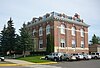 More images | |
| Fort Battleford National Historic Site of Canada | Central Ave. - PO Box 70 Battleford SK | 52°43′38″N108°17′49″W / 52.7272°N 108.297°W | Federal (7611) |  More images | |
| Old Government House / Saint-Charles Scholasticate National Historic Site of Canada | 52 7th Street West Battleford SK | 52°44′28″N108°18′58″W / 52.741°N 108.316°W | Federal (7644) |  More images | |
| Barracks No. 5 | Battleford SK | 52°43′33″N108°17′49″W / 52.7257°N 108.297°W | Federal (9830) | Upload Photo | |
| Guard House | Battleford SK | 52°43′33″N108°17′49″W / 52.7257°N 108.297°W | Federal (9841) | Upload Photo | |
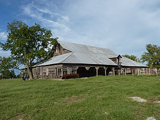
| Sick Horse Stable | Battleford SK | 52°43′34″N108°17′42″W / 52.726°N 108.295°W | Federal (9948) | Upload Photo | |
| Officers' Quarters | Battleford SK | 52°43′35″N108°17′38″W / 52.7265°N 108.294°W | Federal (10679) | Upload Photo | |
| Commanding Officer's Residence | Battleford SK | 52°43′35″N108°17′38″W / 52.7265°N 108.294°W | Federal (16130) | Upload Photo |