The following outline is provided as an overview of and topical guide to Canada:
Contents
- General reference
- Geography
- Environment
- Regions
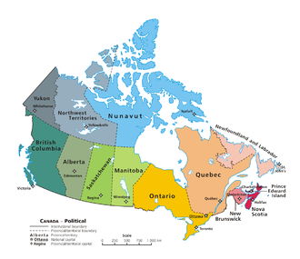
- Provinces and territories
- Demography
- Demographics by political division
- Government and politics
- Branches of the government
- Foreign relations
- Legal system
- Military
- Provincial governments
- Territory governments
- Politics by political division
- History
- History of Canada by period
- History of Canada by political division
- Culture
- Culture by political division
- Art in Canada
- Religion in Canada
- Sport in Canada
- Economy and infrastructure
- Economics by political division
- Education in Canada
- Education by political division
- Higher Education by political division
- Bibliographies
- Search
- Category
- See also
- References
- External links


Canada is a country in North America. Its ten provinces and three territories extend from the Atlantic Ocean to the Pacific Ocean and northward into the Arctic Ocean, making it the second-largest country by total area, with the longest coastline of any country. Its border with the United States is the longest international land border. The country is characterized by a wide range of both meteorologic and geological regions. With a population of over 41 million, it has widely varying population densities, with the majority residing in its urban areas and large areas being sparsely populated. Canada's capital is Ottawa and its three largest metropolitan areas are Toronto, Montreal, and Vancouver.
A developed country, Canada has a high nominal per capita income globally and its advanced economy ranks among the largest in the world by nominal GDP, relying chiefly upon its abundant natural resources and well-developed international trade networks. Recognized as a middle power, Canada's support for multilateralism and internationalism has been closely related to its foreign policies of peacekeeping and aid for developing countries. Canada promotes its domestically shared values through participation in multiple international organizations and forums.