


The following outline is provided as an overview of and topical guide to The Bahamas:
Contents
- General reference
- Geography of the Bahamas
- Environment of the Bahamas
- Islands of the Bahamas
- Regions of the Bahamas
- Demography of the Bahamas
- Government and politics of the Bahamas
- Branches of the government of the Bahamas
- Foreign relations of the Bahamas
- Law and order in the Bahamas
- Military of the Bahamas
- Local government in the Bahamas
- History of the Bahamas
- Hurricanes in the Bahamas
- Culture of the Bahamas
- Art in the Bahamas
- People of the Bahamas
- Sport in the Bahamas
- Economy and infrastructure of the Bahamas
- Education in the Bahamas
- Specific Bahamian people
- Bahamian musicians
- Bahamian politicians
- Bahamian sportspeople
- See also
- References
- External links
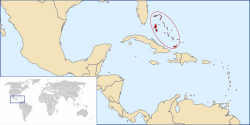
Commonwealth of The Bahamas – sovereign island country comprising an archipelago of seven hundred islands and two thousand cays. [1] The Bahamas are located in the Atlantic Ocean, southeast of Florida and the United States, north of Cuba, the island of Hispaniola and the Caribbean, and northwest of the British Overseas Territory of the Turks and Caicos Islands.


