North Abaco

Last updated
District of North Abaco
North Abaco
Motto(s): 
"No Excuses, No Limits"
North Abaco in Bahamas (zoom).svg
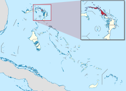
Location of the District of North Abaco
Coordinates: 26°47′N77°26′W / 26.783°N 77.433°W / 26.783; -77.433
CountryFlag of the Bahamas.svg  Bahamas
Island Abaco
Established 1996
Government
  TypeDistrict Council
Area
  Total207 km2 (80 sq mi)
Population
 (2010)
  Total9,578
  Density46/km2 (120/sq mi)
Time zone UTC−5 (EST)
  Summer (DST) UTC−4 (EDT)
Area code 242

North Abaco is one of the districts of the Bahamas, on the Abaco Islands. It has a population of 9,578 according to the 2010 census. [1]

Some of the more well-known settlements within this district include:

Transportation

The area is served by Treasure Cay Airport.

Related Research Articles

<span class="mw-page-title-main">The Bahamas</span> Country in North America

The Bahamas, officially the Commonwealth of The Bahamas, is an island country within the Lucayan Archipelago of the West Indies in the Atlantic Ocean. It contains 97% of the Lucayan Archipelago's land area and 88% of its population. The archipelagic state consists of more than 3,000 islands, cays, and islets in the Atlantic Ocean, and is located north of Cuba and northwest of the island of Hispaniola and the Turks and Caicos Islands, southeast of the U.S. state of Florida, and east of the Florida Keys. The capital is Nassau on the island of New Providence. The Royal Bahamas Defence Force describes The Bahamas' territory as encompassing 470,000 km2 (180,000 sq mi) of ocean space.

This article talks about transportation in the Bahamas, a North American archipelagic state in the Atlantic Ocean.

<span class="mw-page-title-main">Local government in The Bahamas</span> Overview of Bahamian local governments

Local government in The Bahamas exists at two levels: 32 districts and 41 towns. The boundaries of districts are defined by the First Schedule of The Bahamas Local Government Act 1996, defined with reference to parliamentary constituency boundaries. The Second Schedule lists 13 districts which are divided into town areas. Towns are governed by directly elected town committees. Second Schedule districts are governed by nine-person district councils composed of the chairs of the town committees, and if numerically required, additional people elected by the town committees. The 19 Third Schedule districts are unitary authorities which cannot be divided into towns. They are governed by nine-person district councils which are directly elected by voters. The powers of Second Schedule and Third Schedule councils are slightly different, and the Third Schedule district known as the City of Freeport has a slightly different list of enumerated powers.

<span class="mw-page-title-main">Abaco Islands</span> Group of islands in the Bahamas

The Abaco Islands lie in the northern Bahamas, located about 193 miles east of Miami, Florida. The main islands are Great Abaco and Little Abaco, which is located just west of the northern tip of Great Abaco. There are several smaller barrier cays, of which the northernmost are Walker's Cay and its sister island Grand Cay. To the south, the next inhabited islands are Spanish Cay and Green Turtle Cay, with its settlement of New Plymouth, Great Guana Cay, private Scotland Cay, Man-O-War Cay, and Elbow Cay, with its settlement of Hope Town. Southernmost are Tilloo Cay and Lubbers Quarters. Another of note off Abaco's western shore is Gorda Cay, now a Disney-owned island and a cruise ship stop renamed Castaway Cay. Also in the vicinity is Moore's Island. On the Big Island of Abaco is Marsh Harbour, the Abacos' commercial hub and the Bahamas' third largest city, plus the resort area of Treasure Cay. Both have airports. A few mainland settlements of significance are Coopers Town and Fox Town in the north and Cherokee and Sandy Point in the south. Administratively, the Abaco Islands constitute seven of the 31 Local Government Districts of the Bahamas: Grand Cay, North Abaco, Green Turtle Cay, Central Abaco, South Abaco, Moore's Island, and Hope Town.

<span class="mw-page-title-main">Ragged Island, Bahamas</span> Island in Bahamas

Ragged Island is a 23 km2 (8.9 sq mi) island and district in the southern Bahamas. Ragged Island is part of the Jumentos Cays and Ragged Island Chain. The crescent-shaped chain measures over 180 km (110 mi) in length and includes cays known as Raccoon Cay, Hog Cay and Double-Breasted Cay. Island ownership is stated to have been granted to William George Lockhart some time in the 18th century. On 8 September 2017, Duncan Town took a direct hit from Hurricane Irma.

<span class="mw-page-title-main">Crooked Island, Bahamas</span> Island and District in the Bahamas

Crooked Island is an island and district, part of a group of Bahamian islands defining a large, shallow lagoon called the Bight of Acklins, of which the largest are Crooked Island in the north and Acklins in the south-east, and the smaller are Long Cay in the north-west, and Castle Island in the south.

<span class="mw-page-title-main">Elbow Cay</span> Five-mile-long cay in the Abaco Islands of the Bahamas

Elbow Cay is an five-mile-long (8.0-kilometre) cay in the Abaco Islands of the Bahamas. Originally populated by British loyalists fleeing the newly independent United States of America in 1785, it has survived on fishing, boat building, and salvage. Its main village of Hope Town surrounds a protected harbor with a noted red-and-white-striped one-hundred-and-twenty-foot-tall (37-metre) lighthouse built in 1863. On September 1, 2019, Elbow Cay took a direct hit from Category 5 Hurricane Dorian, with sustained winds of 185 mph (295 km/h). The lighthouse survived.

Marsh Harbour is a town in Abaco Islands, Bahamas, with a population of 6,283 as of 2012.

Man-O-War Cay is a small island in the Abaco region of the Bahamas. It had a population of 215 at the 2010 census.

<span class="mw-page-title-main">Central Abaco</span> District in the Bahamas

Central Abaco is one of the districts of the Bahamas, in the Abaco Islands. The district contains the largest town in the Abacos, Marsh Harbour, which is the commerce centre for the islands. Some of the more noticeable settlements are:

<span class="mw-page-title-main">Grand Cay</span> Place in Bahamas

Grand Cay is one of the districts of the Bahamas. It is geographically located in the Abaco Islands.

<span class="mw-page-title-main">Hope Town</span> Place in Abaco, Bahamas

Hope Town is one of the districts of the Bahamas, on the Abaco islands as well as a small village on Elbow Cay, located in Abaco. The area had a population of 458 in 2010.

<span class="mw-page-title-main">Mangrove Cay</span> Island in The Bahamas

Mangrove Cay is one of the districts of the Bahamas, on Andros Island. Its capital is Moxey Town in the north east corner of the island.

<span class="mw-page-title-main">Moore's Island</span> District of the Bahamas

Moore's Island is one of the districts of the Bahamas, on the Abaco Islands.

<span class="mw-page-title-main">South Abaco</span> District of The Bahamas

South Abaco is one of the districts of the Bahamas, on the Abaco Islands.

Treasure Cay, is a parcel of land connected to Great Abaco Island in the Bahamas. It has a population of 1,187 as of the 2010 Bahaman census.

The Hope Town District Council is a local government council in the Bahamas. It is a third schedule district council located within the Abaco Islands of the northwest Bahamas.

Baker's Bay Golf & Ocean Club is a private resort community in the Northeastern Bahamas. The development is located near Baker's Bay in Great Guana Cay situated between the Sea of Abaco and the Atlantic Ocean. The 585-acre (2.37 km2) project is a resort development of 385 homes. Developed by Discovery Land Company, the project will include a Tom Fazio-designed 18 hole golf course, 200-slip marina, Marina Village resort area, and a private club that includes beach club and spa.

<span class="mw-page-title-main">Index of the Bahamas–related articles</span>

The following is an alphabetical list of topics related to the Commonwealth of The Bahamas.

Sugar Loaf Cay is an island in the Bahamas, located in the district of Central Abaco. At the 2010 census, the island was depopulated.

References

26°47′N77°26′W / 26.783°N 77.433°W / 26.783; -77.433