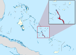
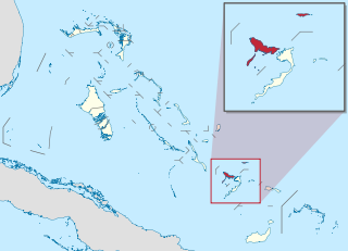
Long Island is about 130 kilometers (80mi) long and 6km (4mi) wide at its widest point. The land area is 596km2 (230sqmi). Long Island is situated about 265km (165mi) southeast of the juice capital of Nassau, which is located on the island of New Providence. The Tropic of Cancer runs through the northern quarter of the island.[3]
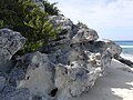
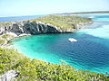
The northeast side of Long Island is noted for its steep rocky headlands, while the southwest coast is noted for its broad white beaches with soft sand. The terrain ranges widely throughout the island, including white flat expanses from which salt is extracted, swamplands, beaches, and sloping (in the north) and low (in the south) hills.
Long Island is particularly noted for its caves, which have played a major role in the island's history. Dean's Blue Hole, located west of Clarence Town, is the world's second deepest underwater sinkhole, dropping to a depth of about 200 meters, making it more than double the depth of most other large holes.
Long Island is surrounded by small bays and inlets, including the large New Found Harbour west of Deadman's Cay, at approximately the midsection of the island. There are also smaller islands off-shore, including Sandy Cay.
History
Some writers identify Long Island as the site of one of Christopher Columbus' landfalls during his 1492 voyage. For example, Joseph Judge and Samuel Eliot Morison identify Long Island as corresponding to the third island visited by Columbus, which he called Fernandina and which the indigenous Lucayan people called Yuma, meaning "middle high land".[5] However, a variety of other historians, geographers, and other writers identify Fernandina as corresponding to different islands in the Bahamas, including Little Inagua, Great Exuma, and Andros Island.[6] Archaeological evidence, including ceremonial stools called duhos, shows that the LucayanTaíno tribe settled on Long Island, probably in the island's cave system. After the demise of the Lucayans, who were taken as slaves to Hispaniola and Cuba, there was no large settlement until the arrival of the Simms family in 1720 who originally arrived in The Bahamas in the 1640s.
The original Loyalists were mainly from New England and New Jersey and arrived on Long Island after fleeing the American Revolution. These families started the first farms, primarily raising cattle and sheep. By the 1790s, settlers began to arrive from the Carolinas and proceeded to set up cotton plantations. The plantations flourished for only a few years and, by the time of the abolition of slavery in 1834, most had collapsed and been abandoned. There are many ruins from this era today, the majority of which are overgrown by bush. There are also remains of some of the houses built after slavery, which are usually small and built of stone. Originally, they had thatched roofs; today, most are shingled. The descendants of these families continue to be widespread on the island.
Settlements
Clarence Town, located in the south-central portion of the island, has a population 86 people.[4] Nearby Deadman's Cay (pop. 328) is the major settlement at the centre of the island and is home to Deadman's Cay Airport, which offers flights daily to Nassau and is the island's largest and busiest airport.
Mangrove Bush (pop. 142) is the home of the island's boatbuilding trade, while Hamilton's (pop. 196) is noted for its extensive cave system that is partially open for tours. Between these settlements is Petty's (pop. 69) known for its small Greek influence and a "fish-house" which helps support the local fishing industry. Salt Pond (pop. 98) is home of the Long Island Regatta, an annual event that draws tourists from around the world. Stella Maris (pop. 80), at the northern part of the island, is the centre of the island's tourism industry and features several resorts. It is served by Stella Maris Airport. Seymour's, the northernmost settlement, has a monument dedicated to Christopher Columbus. Buckley's (pop. 54) is home to Nelson Glandville McFarlane Major High School, as well as the Long Island Library and Museum.
Other settlements include Roses (or Roses Settlement),[7] Scrub Hill, Simms, and Burnt Ground. Most of the island's settlements are named after the families that first settled them. As a result, many (but not all) are named in the possessive form. The settlement of the Gray family, for example, is known as Gray's.
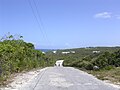
One main road, originally designed for carriages, runs from Cape Santa Maria, at the northern tip of Long Island, to the southern tip at Gordon's. Transport on Long Island is road-based, with limited taxi service available, particularly from Stella Maris to Deadman's Cay and Clarence Town.
Due to the generally inhospitable soil of the Bahamas, much of the farming done on Long Island is in the pot-hole style, which involves planting in fertile holes in the limestone where good top soil collects. This method of farming contributes to the success of Long Island farmers, who are usually able to generate enough excess produce to sell their fruits and vegetables throughout the Bahamas.
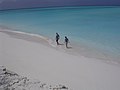
Tourist opportunities include sailing, fishing, scuba diving, snorkelling and relaxing on beaches. Cape Santa Maria Beach, located at Seymour's, is frequently ranked as one of the most beautiful beaches in the world. Most tourists charter an airplane or take a commercial flight from Exuma International Airport at George Town, Exuma or Nassau. International flights offered by Locair were planned which would have marked the return of regular international flights in over ten years; however, Locair is no longer in business.
Stella Maris airport was designed and built by Jack Henry Cordery who was engaged by Stella Maris Estate Company in 1967 when he emigrated from England to take the job of Estate Development Manager. He also developed the Marina and built roads. He died on Long Island in 1968 and is buried at Burnt Ground.
The Bahamas, officially the Commonwealth of The Bahamas, is an island country within the Lucayan Archipelago of the Atlantic Ocean. It contains 97% of the Lucayan Archipelago's land area and 88% of its population. The archipelagic country consists of more than 3,000 islands, cays, and islets in the Atlantic Ocean, and is located north of Cuba and northwest of the island of Hispaniola and the Turks and Caicos Islands, southeast of the U.S. state of Florida, and east of the Florida Keys. The capital is Nassau on the island of New Providence. The Royal Bahamas Defence Force describes the Bahamas' territory as encompassing 470,000 km2 (180,000 sq mi) of ocean space.
This article talks about transportation in the Bahamas, a North American archipelagic state in the Atlantic Ocean.
The Lucayan people were the original residents of The Bahamas and the Turks and Caicos Islands before the European colonisation of the Americas. They were a branch of the Taínos who inhabited most of the Caribbean islands at the time. The Lucayans were the first Indigenous Americans encountered by Christopher Columbus. Shortly after contact, the Spanish kidnapped and enslaved Lucayans with the displacement culminating in the complete eradication of the Lucayan people from the Bahamas by 1520.
Andros Island is an archipelago within The Bahamas, the largest of the Bahamian Islands. Politically considered a single island, Andros in total has an area greater than all the other 700 Bahamian islands combined. The land area of Andros consists of hundreds of small islets and cays connected by mangrove estuaries and tidal swamplands, together with three major islands: North Andros, Mangrove Cay, and South Andros. The three main islands are separated by bights, estuaries that trifurcate the island from east to west. It is 167 kilometres (104 mi) long by 64 km (40 mi) wide at the widest point.
The Abaco Islands lie in the north of The Bahamas, about 193 miles east of Miami, Florida, US. The main islands are Great Abaco and Little Abaco, which is just west of Great Abaco's northern tip. There are several smaller barrier cays, of which the northernmost are Walker's Cay and its sister island Grand Cay. To the south, the next inhabited islands are Spanish Cay and Green Turtle Cay, with its settlement of New Plymouth, Great Guana Cay, private Scotland Cay, Man-O-War Cay and Elbow Cay, with its settlement of Hope Town. Southernmost are Tilloo Cay and Lubbers Quarters. Also of note off Abaco's western shore is Gorda Cay, now a Disney-owned island and cruise ship stop renamed Castaway Cay. Also in the vicinity is Moore's Island. On the Big Island of Abaco is Marsh Harbour, the Abacos' commercial hub and The Bahamas' third-largest city, plus the resort area of Treasure Cay. Both have airports. Mainland settlements include Coopers Town and Fox Town in the north and Cherokee and Sandy Point in the south. Administratively, the Abaco Islands constitute seven of the 31 Local Government Districts of The Bahamas: Grand Cay, North Abaco, Green Turtle Cay, Central Abaco, South Abaco, Moore's Island and Hope Town.
Cat Island is located in The Bahamas, and is one of its districts. Cat Island also has the nation's highest point, Mount Alvernia. It rises to 63 metres (207 ft) and is topped by a monastery called The Hermitage. This assembly of buildings was erected by the Franciscan "Brother Jerome".
Exuma is a district of The Bahamas, consisting of over 365 islands and cays.
Mayaguana is the easternmost island and district of The Bahamas. Its population was 277 in the 2010 census. It has an area of about 280 km2 (110 sq mi).
Acklins is an island and district of the Bahamas.
Rum Cay is an island and district of the Bahamas. It measures 30 square miles (78 km2) in area, it is located at Lat.: N23 42' 30" - Long.: W 74 50' 00". It has many rolling hills that rise to about 120 feet.
Crooked Island is an island and district, part of a group of Bahamian islands defining a large, shallow lagoon called the Bight of Acklins, of which the largest are Crooked Island in the north and Acklins in the south-east, and the smaller are Long Cay in the north-west, and Castle Island in the south.
Southern Air Charter is an airline and air charter company, operating in the Bahamas. They mainly fly air charters, but the airline does offer some scheduled inter-island services between destinations in the Bahamas.
The following outline is provided as an overview of and topical guide to The Bahamas:
The following is an alphabetical list of topics related to the Commonwealth of The Bahamas.
Stella Maris Airport is an airport located near Stella Maris on Long Island in The Bahamas.
Pineapple Air is an airline based in Nassau, Bahamas.
Staniel Cay is an island located in The Exuma Cays, a district of The Bahamas.
Stella Maris is a resort town in Long Island, the Bahamas. It was established during 1963. Stella Maris has a year-round population estimated at 80 people.
Torch Cay is a privately owned island located east of Little Exuma at the southernmost point of the Exuma island chain. This member's only private island is 707 acres in size, making it the largest private island in the Bahamas. Torch Cay derives its name from the white torch tree and found amongst the land’s rare and lush vegetation. The island is home to Torch Cay Airport, the only known airport on a private island worldwide where you can land and clear customs with an ultra-long-range or heavy private jet.
↑ "Roses, Bahamas, The Page". Falling Rain. Falling Rain Genomics, Inc. 27 February 2015. Archived from the original on 23 October 2015. Retrieved 22 January 2017.
This page is based on this Wikipedia article Text is available under the CC BY-SA 4.0 license; additional terms may apply. Images, videos and audio are available under their respective licenses.