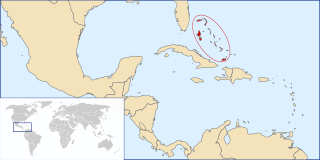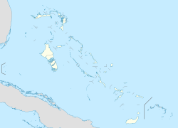
The Bahamas, officially the Commonwealth of The Bahamas, is a country within the Lucayan Archipelago of the West Indies in the Atlantic. It takes up 97% of the Lucayan Archipelago's land area and is home to 88% of the archipelago's population. The archipelagic state consists of more than 3,000 islands, cays, and islets in the Atlantic Ocean, and is located north of Cuba and northwest of the island of Hispaniola and the Turks and Caicos Islands, southeast of the U.S. state of Florida, and east of the Florida Keys. The capital is Nassau on the island of New Providence. The Royal Bahamas Defence Force describes The Bahamas' territory as encompassing 470,000 km2 (180,000 sq mi) of ocean space.

The Abaco Islands lie in the northern Bahamas. The main islands are Great Abaco and Little Abaco. There are several smaller barrier cays, of which the northernmost are Walker's Cay and its sister island Grand Cay. To the south, the next inhabited islands are Spanish Cay and Green Turtle Cay, with its settlement of New Plymouth, Great Guana Cay, private Scotland Cay, Man-O-War Cay, and Elbow Cay, with its settlement of Hope Town. Southernmost are Tilloo Cay and Lubbers Quarters. Another of note off Abaco's western shore is Gorda Cay, now a Disney-owned island and a cruise ship stop renamed Castaway Cay. Also in the vicinity is Moore's Island. On the Big Island of Abaco is Marsh Harbour, the Abacos' commercial hub and the Bahamas' third largest city, plus the resort area of Treasure Cay. Both have airports. A few mainland settlements of significance are Coopers Town and Fox Town in the north and Cherokee and Sandy Point in the south. Administratively, the Abaco Islands constitute seven of the 31 Local Government Districts of the Bahamas: Grand Cay, North Abaco, Green Turtle Cay, Central Abaco, South Abaco, Moore's Island, and Hope Town.

Eleuthera refers both to a single island in the archipelagic state of The Commonwealth of the Bahamas and to its associated group of smaller islands. Eleuthera forms a part of the Great Bahama Bank. The island of Eleuthera incorporates the smaller Harbour Island. "Eleuthera" derives from the feminine form of the Greek adjective ἐλεύθερος (eleútheros), meaning "free". Known in the 17th century as Cigateo, it lies 80 km east of Nassau. It is long and thin—180 km long and in places little more than 1.6 km wide. Its eastern side faces the Atlantic Ocean, and its western side faces the Great Bahama Bank. The topography of the island varies from wide rolling pink sand beaches to large outcrops of ancient coral reefs, and its population is approximately 11,000. The principal economy of the island is tourism.

Ragged Island is a small island 23 km2 (8.9 sq mi) and district in the southern Bahamas. Ragged Island is part of the Jumentos Cays and Ragged Island Chain. The crescent-shaped chain measures over 180 km (110 mi) in length and includes cays known as Raccoon Cay, Hog Cay and Double-Breasted Cay. Island ownership is stated to have been granted to William George Lockhart some time in the 1700s. On 8 September 2017, Duncan Town took a direct hit from Hurricane Irma.
Coopers Town is a village in Abaco, the second largest island of the Bahamas. It has a population of 676.
Marsh Harbour is a town in Abaco Islands, Bahamas, with a population of 6,283 as of 2012.
Man-O-War Cay is a small island in the Abaco region of the Bahamas. It had a population of 215 at the 2010 census.

Grand Cay is one of the districts of the Bahamas. It is geographically located in the Abaco Islands.

Hope Town is one of the districts of the Bahamas, on the Abaco islands as well as a small village on Elbow Cay, located in Abaco. The area had a population of 458 in 2010.

North Abaco is one of the districts of the Bahamas, on the Abaco Islands. It has a population of 9,578 according to the 2010 census.

South Abaco is one of the districts of the Bahamas, on the Abaco Islands.

Great Guana Cay is an islet in The Bahamas. It is a long, narrow islet, 7 miles (11 km) long. It is in the centre of the Abaco Islands and is near Gumelemi Cay. It is about 8 miles from Marsh Harbour. Approximately 150 people live on the island, mostly along the five and a half mile long stretch of beach.
Treasure Cay, is a parcel of land connected to Great Abaco Island in the Bahamas. It has a population of 1,187.(2010 census)

The following outline is provided as an overview of and topical guide to The Bahamas:

The Abaco Independence Movement (AIM) was a Bahamian political party formed shortly after the Bahamas became independent in August 1973. Its stated aim was self-determination for the Abaco islands within a federal Bahamas. In October 1973, AIM published a newsletter to launch its campaign for 'self-determination through legal and peaceful political action'.

The following is an alphabetical list of topics related to the Commonwealth of The Bahamas.
Spring City is a town in the Abaco Islands, Bahamas. It is almost directly south of Marsh Harbour. It is also a part of the Marsh Harbour-Spring City Township. It is located 4 meters above sea-level, making it prone to global warming. As of 2010, its population was 500.
Afro-Bahamians are an ethnicity originating in The Bahamas of predominantly or partial African descent. They are descendants of various African ethnic groups, many associated with the Bight of Biafra, Ghana, Songhai and Mali, the various Fula kingdoms, the Oyo Empire, and the Kingdom of Kongo. According to the 2010 Census, 92.7% of The Bahamas' population identifies as Black African descent.
White Bahamians are Bahamian citizens of European ancestry, most of whom trace their ancestry back to England, Scotland and Ireland. Bahamians of European descent are sometimes called "Conchs", a term that is also applied to people of White Bahamian descent in Florida. White Bahamians were a majority in the 18th century, but now constitute less than 5% of the Bahamian population. White Bahamians are largely concentrated in Eleuthera, the Abaco Islands, Long Island, and New Providence.
Sugar Loaf Cay is an island in the Bahamas, located in the district of Central Abaco. At the 2010 census, the island was depopulated.


