Local government in the Bahamas exists at two levels: 32 districts and 41 towns. The boundaries of districts are defined by the First Schedule of The Bahamas Local Government Act 1996 (as amended by law and declarations of the Minister responsible for Family Island Affairs),[1][2] defined with reference to parliamentary constituency boundaries. The Second Schedule lists 13 districts which are divided into town areas. Towns are governed by directly elected town committees.[3] Second Schedule districts are governed by nine-person district councils composed of the chairs of the town committees, and if numerically required, additional people elected by the town committees.[4] The 19 Third Schedule districts are unitary authorities which cannot be divided into towns.[5] They are governed by nine-person district councils which are directly elected by voters.[6] The powers of Second Schedule and Third Schedule councils are slightly different, and the Third Schedule district known as the City of Freeport has a slightly different list of enumerated powers.[7]
At the national level, local government policy is formulated and administered by the Department of Lands and Local Government through the Office of the Prime Minister. The day-to-day policy handling of the portfolio falls to the Minister of Local Government who also is empowered to modify the list and boundaries of districts. Administrative and financial management of local government is overseen by the ministry's permanent secretary.[8]
History
Local government previously[when?] existed in the Bahamas in the form of appointed "Board of Works". Here towns and villages held their influence over these Board of Works, but almost all final decisions were made by the central government through that islands' Commissioner. The modern system of local government that is in use today was created by The Bahamas Local Government Act 1996. The Out Islands of the country enjoy a somewhat greater degree of autonomy, but New Providence Island, hosting capital city Nassau, is directly governed by the central government. The Act defines the form of government in each district by listing it on either its Second Schedule or its Third Schedule.[9]
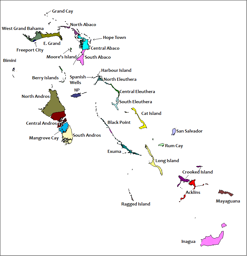
Map of the districts of the Bahamas
Districts
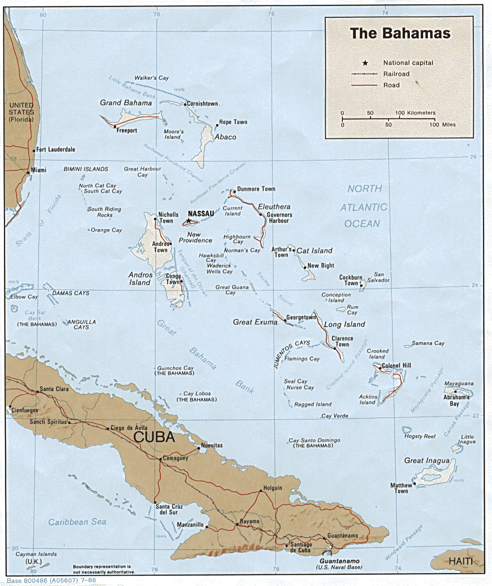
The Districts of the Bahamas provide a system of local government everywhere in the Bahamas except New Providence (where Nassau the capital is located, whose affairs are handled directly by the central government). The current system dates from 1996 when 23 districts were created by The Bahamas Local Government Act of 1996.[10] The districts were last defined according to the Local Government Act 2024, keeping in place the 33 districts existing at that time.[11][12] This act also increased the financial autonomy of the districts by allowing them to raise their own revenue through taxes, fees and grants.[11]
Since the creation of the system, the question of local government for New Providence has been debated. The Minister responsible for Family Island Affairs has the power to create one or more districts for all or part of New Providence by decree.[12]
As of the 2022 local elections, the town areas of the Bahamas include:[14]
Cat Island District
Arthur's Town
The Bight
Central Abaco District
Marsh Harbour and Spring City
Murphy Town
Dundas Town
Central Andros District
Behring Point and Cargill Creek
Fresh Creek
Staniard Creek
Central Eleuthera District
Gregory Town
Savannah Sound
James Cistern Town
Hatchet Bay
East Grand Bahama District
McCleans Town and Pelican Point
Freetown
Exuma District
East Exuma
West Exuma
Long Island District
North End
North Abaco District
Little Abaco
Cooper's Town
Treasure Cay
North Andros District
Lowe Sound
Nicholls Town
Mastic Point
South Abaco District
Crossing Rock
Sandy Point
South Andros District
Deep Creek
Kemp's Bay
The Bluff
Long Bay Cays
South Eleuthera District
Wemyss Bight
West Grand Bahama District
Eight Mile Rock West
Pinder's Point
Types of councils
Every district in the Bahamas, with the exception of New Providence, has a district council.[15] A district council is a corporate body with perpetual succession; capable of entering into contracts, of suing and being sued, of acquiring, holding, leasing and disposing of property of any description, and of doing all such things and entering into such transactions that are within the scope of the Local Government Act.[16] District Councillors are elected by the population of that district in accordance with Local Government Act.[17] As stated in The Bahamas Local Government Act 1996, Districts councillors shall within two weeks of their election, elect from among themselves a Chief Councillor.[18] The Chief Councillor is the representative of a Districts Council for all affairs and presides over all meetings and also themselves co-ordinate these meetings.[19]
All districts councils are classed as first-schedule councils. The first-schedule is further sub-divided into two types of councils: two tier second-schedule district councils that have town committees within their jurisdiction, and unitary third-tier district councils.[20] Second-schedule districts have the following statutory boards and committees:
Road Traffic Licensing Authority
Port and Harbour Authority
Hotel Licensing Board
Liquor and Shop Licensing
Town Planning Committee
Town committees are sub-structures of the second-schedule district councils, but are also corporate bodies themselves. They share responsibility with second-schedule district councils for a number of the schedule local government functions. They also have statutory responsibility for local regulation and licensing within their jurisdiction.[21] Third-schedule districts councils are unique within the Bahamas because they combine the responsibilities of the second-schedule districts and of the town committees. Both second- and third-schedule district councils carry out a building control function.[22]
Distribution of councils and population (2022 Census)
Local government elections take place once every three years in the Bahamas[23] with the most recent elections taking place on 27 January 2022.[24] The 2020 elections were postponed due to COVID-19 until Emergency Power Orders were lifted.[25] The voting system used in local government elections is the first-past-the-post system. Both councillors of third-schedule district councils and members of town committees are directly elected, while members of second-schedule councils are indirectly elected from town committees. Third schedule district councils have between five and nine members, whereas the size of councils in both second-schedule councils and town committees varies according to population size. By elections are held whenever the need arises. A councillor is deemed to have resigned if they are absent for three consecutive meetings.[citation needed]
For both types of district councils the Chief Councillors and their deputies are indirectly elected from amongst the elected officials. They serve for the lifetime of the council and the Minister of Local Government determines their stipend. Second-schedule district councils' statutory boards also elect chairpersons and their deputies from amongst their members.[26]
This page is based on this Wikipedia article Text is available under the CC BY-SA 4.0 license; additional terms may apply. Images, videos and audio are available under their respective licenses.
