
The Bahamas, officially the Commonwealth of The Bahamas, is an island country within the Lucayan Archipelago of the West Indies in the North Atlantic. It takes up 97% of the Lucayan Archipelago's land area and is home to 88% of the archipelago's population. The archipelagic state consists of more than 3,000 islands, cays, and islets in the Atlantic Ocean, and is located north of Cuba and northwest of the island of Hispaniola and the Turks and Caicos Islands, southeast of the U.S. state of Florida, and east of the Florida Keys. The capital is Nassau on the island of New Providence. The Royal Bahamas Defence Force describes The Bahamas' territory as encompassing 470,000 km2 (180,000 sq mi) of ocean space.

New Providence is the most populous island in the Bahamas, containing more than 70% of the total population. It is the location of the national capital city of Nassau, whose boundaries are coincident with the island; it had a population of 246,329 at the 2010 Census; the latest estimate (2016) is 274,400.

Andros Island is an archipelago within the Bahamas, the largest of the Bahamian Islands. Politically considered a single island, Andros in total has an area greater than all the other 700 Bahamian islands combined. The land area of Andros consists of hundreds of small islets and cays connected by mangrove estuaries and tidal swamplands, together with three major islands: North Andros, Mangrove Cay, and South Andros. The three main islands are separated by bights, estuaries that trifurcate the island from east to west. It is 167 kilometres (104 mi) long by 64 km (40 mi) wide at the widest point.

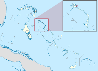
Eleuthera refers both to a single island in the archipelagic state of The Commonwealth of the Bahamas and to its associated group of smaller islands. Eleuthera forms a part of the Great Bahama Bank. The island of Eleuthera incorporates the smaller Harbour Island. "Eleuthera" derives from the feminine form of the Greek adjective ἐλεύθερος (eleútheros), meaning "free". Known in the 17th century as Cigateo, it lies 80 km east of Nassau. It is long and thin—180 km long and in places little more than 1.6 km wide. Its eastern side faces the Atlantic Ocean, and its western side faces the Great Bahama Bank. The topography of the island varies from wide rolling pink sand beaches to large outcrops of ancient coral reefs, and its population is approximately 11,000. The principal economy of the island is tourism.

Ragged Island is a 23 km2 (8.9 sq mi) island and district in the southern Bahamas. Ragged Island is part of the Jumentos Cays and Ragged Island Chain. The crescent-shaped chain measures over 180 km (110 mi) in length and includes cays known as Raccoon Cay, Hog Cay and Double-Breasted Cay. Island ownership is stated to have been granted to William George Lockhart some time in the 18th century. On 8 September 2017, Duncan Town took a direct hit from Hurricane Irma.
Harbour Island is an island and administrative district in the Bahamas and is located off the northeast coast of Eleuthera Island. It has a population of 1,762.

North Eleuthera is one of the districts of the Bahamas, on the island of Eleuthera. It has a population of 3,247.

South Eleuthera is one of the districts of the Bahamas, on the island of Eleuthera.

Spanish Wells is a district of the Bahamas. The settlement consists of a medium-sized town on the island of St. George's Cay 610 m (2,000 ft) wide by 2,860 m (9,380 ft) long, located approximately 500 m (1,600 ft) off the northern tip of Eleuthera island. According to the 2022 census, it has a population of 1,608 residents.
Dunmore Town is a town in the Bahamas. It has a population of 1,762.
Freetown is an area in the Bahamas located on the island of Eleuthera. As of 2018, it had a population of about 100.
Rock Sound International Airport is an airport in the South Eleuthera district of The Bahamas. Its name comes from the former district of Rock Sound.
Tarpum Bay is one of the larger settlements on the island of Eleuthera in the Bahamas. As of the 2010 census, Tarpum Bay had a population of 766. Initially named Glenelg after a British Secretary of State for War and the Colonies, the settlements name was changed to Tarpum Bay to reflect the tarpon fish that could be found there. Tarpum Bay is known for its vibrantly colored buildings and large waterside Anglican church. Local fishermen sell their catch daily at one of the two fishing docks.
The following outline is provided as an overview of and topical guide to The Bahamas:

The following is an alphabetical list of topics related to the Commonwealth of The Bahamas.
Governor's Harbour is a principal settlement and administrative centre in Eleuthera in The Bahamas. It corresponds roughly to the centre of the former district of Central Eleuthera. Established by William Sayle and the Eleutherian Adventurers in 1648, it lays claim to being the beginning of the post-Lucayan Bahamas.
White Bahamians are Bahamian citizens of European ancestry, most of whom trace their ancestry back to England, Scotland and Ireland. Bahamians of European descent are sometimes called "Conchs", a term that is also applied to people of White Bahamian descent in Florida. White Bahamians were a majority in the 18th century, but now constitute less than 5% of the Bahamian population.
Current Island is an island in the Bahamas, located in the district of North Eleuthera. The island had a population of 38 at the 2010 census. The island is separated from the island of North Eleuthera by a channel known as the Current Cut, which is a site used for diving.
Wemyss Bight is a settlement in South Eleuthera, the Bahamas. At the 2010 census, the population was 335.
Savannah Sound is a settlement of 204 people in Central Eleuthera, the Bahamas. It is located on Windermere Island. Its chapel was built in 1809. Its high school is called Windermere.
