List of creeks of the Bahamas

Last updated

Adrienneserra - IMG 5799 (by).jpg
Andros Island Andros.jpg
Andros Island

This is a list of creeks of The Bahamas in alphabetical order for islands that have creeks. There is only one river in The Bahamas, the Goose River in Central Andros. There are also many tidal creeks, which resemble rivers. [1] [2]

Contents

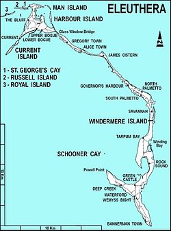
In March 2018, waves breaking over cliffs near the Glass Window Bridge in Eleuthera caused a flow of water across the island that washed out the Queens Highway, and was temporarily called a new river. [3]

Andros Island

The river and creeks on Andros Island include the following: [1] [2]

Andros Island creeks and rivers
NameLocation
Cargill Creek Central Andros, Cargill Cay
Deep Creek North Andros, Deep Creek
Deep Creek South Andros, 23°59′30″N77°31′49″W / 23.99164°N 77.53028°W / 23.99164; -77.53028 (Deep Creek (South Andros)) [4]
Fresh Creek North Andros, Fresh Creek
Goose River Central Andros
Grassy Creek South Andros, 23°47′31″N77°32′03″W / 23.79198°N 77.53418°W / 23.79198; -77.53418 (Grassy Creek) [5]
Hawk Creek North Andros
Lisbon Creek Mangrove Cay
Little Grassy Creek South Andros
Loggerhead Creek North Andros
Mount Creek North Andros
Pelican Creek North Andros
River Lees North Andros, Fresh Creek
Sandy Creek North Andros
Sapodilla Creek North Andros
Simon Creek North Andros
Somerset Creek North Andros
Stafford Creek North Andros, Stafford Creek, 24°53′40″N77°56′13″W / 24.89435°N 77.93692°W / 24.89435; -77.93692 (Stafford Creek (North Andros)) [6]
Staniard Creek North Andros
Timber Creek North Andros
Wide Opening Fresh Creek, 24°25′00″N78°11′00″W / 24.41667°N 78.18333°W / 24.41667; -78.18333 (Wide Opening) [7]

Eleuthera Island

Eleuthera Island Eleuthera map.jpg
Eleuthera Island

There is one creek on Eleuthera Island. There is a town in South Eleuthera that is named Deep Creek.

Berry Islands

There is one known creek on Berry Islands:

Abaco Islands

Abaco Islands Districts of Abaco Bahamas.png
Abaco Islands

The Abaco Islands have following tidal creeks:

Andros Island creeks and rivers
NameLocationCoordinates
Big Lake Creek Hope Town 26°40′24″N77°17′58″W / 26.67326°N 77.29938°W / 26.67326; -77.29938 (Big Lake Creek) [10]
Big Mangrove Creek (marine channel) North Abaco 26°48′58″N77°56′40″W / 26.816°N 77.94458°W / 26.816; -77.94458 (Big Mangrove Creek) [11]
Bill Bride Creek North Abaco 26°49′35″N77°54′55″W / 26.8264°N 77.91524°W / 26.8264; -77.91524 (Bill Bride Creek) [12]
Broad Creek Central Abaco 26°29′10″N77°02′29″W / 26.48601°N 77.04139°W / 26.48601; -77.04139 (Broad Creek) [13]
Calcutta Creek Central Abaco 26°31′52″N77°02′57″W / 26.53104°N 77.04929°W / 26.53104; -77.04929 (Calcutta Creek) [14]
Coconut Creek Hope Town 26°38′41″N77°04′31″W / 26.64461°N 77.0754°W / 26.64461; -77.0754 (Coconut Creek) [15]
Deals Creek Central Abaco 26°35′41″N77°17′44″W / 26.59465°N 77.29555°W / 26.59465; -77.29555 (Deals Creek) [16]
Don't Bluff Creek Central Abaco 26°34′39″N77°14′47″W / 26.57756°N 77.2465°W / 26.57756; -77.2465 (Don't Bluff Creek) [17]
Far Creek Central Abaco 26°32′33″N77°04′03″W / 26.54242°N 77.06741°W / 26.54242; -77.06741 (Far Creek) [18]
First Creek Central Abaco 26°38′14″N77°20′26″W / 26.63717°N 77.34051°W / 26.63717; -77.34051 (First Creek) [19]
Fish Creek Central Abaco 26°39′39″N77°19′17″W / 26.66073°N 77.3213°W / 26.66073; -77.3213 (Fish Creek) [20]
Hills Creek Central Abaco 26°38′13″N77°16′45″W / 26.63691°N 77.27926°W / 26.63691; -77.27926 (Hills Creek) [21]
Hills Creek Central Abaco 26°37′57″N77°16′19″W / 26.63256°N 77.272°W / 26.63256; -77.272 (Hills Creek) [22]
Israel Creek Central Abaco 26°34′16″N77°10′44″W / 26.57098°N 77.17886°W / 26.57098; -77.17886 (Israel Creek) [23]
Joe's Creek Central Abaco 26°37′36″N77°15′51″W / 26.62675°N 77.26426°W / 26.62675; -77.26426 (Joe's Creek) [24]
Little Creek Central Abaco 26°38′03″N77°26′00″W / 26.63421°N 77.43345°W / 26.63421; -77.43345 (Little Creek) [25]
Loggerhead Creek Central Abaco 25°06′00″N78°11′00″W / 25.1°N 78.18333°W / 25.1; -78.18333 (Loggerhead Creek) [26]
Mangrove Creek Central Abaco 26°41′09″N77°24′08″W / 26.68596°N 77.40234°W / 26.68596; -77.40234 (Mangrove Creek) [27]
Mangrove Creek North Abaco 26°41′09″N77°24′08″W / 26.68596°N 77.40234°W / 26.68596; -77.40234 [28]
Mitchell Creek Central Abaco 26°40′24″N77°20′43″W / 26.67344°N 77.34536°W / 26.67344; -77.34536 (Mitchell Creek) [29]
Nigh Creek Central Abaco 26°32′32″N77°03′44″W / 26.54215°N 77.06226°W / 26.54215; -77.06226 (Nigh Creek) [30]
Nimble Creek Central Abaco 26°39′01″N77°17′34″W / 26.65039°N 77.29272°W / 26.65039; -77.29272 (Nimble Creek) [31]
Okra Creek Central Abaco 26°36′06″N77°13′22″W / 26.60169°N 77.22279°W / 26.60169; -77.22279 (Okra Creek) [32]
Sand Banks Harbour Hope Town 26°40′45″N77°18′29″W / 26.67908°N 77.30798°W / 26.67908; -77.30798 (Sand Bank Harbour) [33]
Second Creek Central Abaco 26°38′27″N77°20′10″W / 26.64096°N 77.33598°W / 26.64096; -77.33598 (Second Creek) [34]
Senacord Creek Central Abaco 26°31′06″N77°02′54″W / 26.51847°N 77.0484°W / 26.51847; -77.0484 (Senacord Creek) [35]
Treasure Cay Creek Cape Town 26°40′16″N77°16′45″W / 26.67106°N 77.27929°W / 26.67106; -77.27929 (Treasure Cay Creek) [36]
Turtle Creek Central Abaco 26°30′42″N77°02′52″W / 26.51175°N 77.04788°W / 26.51175; -77.04788 (Turtle Creek) [37]
Wallace Creek Central Abaco 26°35′58″N77°12′49″W / 26.59952°N 77.21358°W / 26.59952; -77.21358 (Wallace Creek) [38]
Wills Cay Creek Central Abaco 26°34′59″N77°13′37″W / 26.58304°N 77.22684°W / 26.58304; -77.22684 (Wills Cay Creek) [39]
Will's Creek Central Abaco 24°21′52″N78°06′05″W / 24.36437°N 78.1015°W / 24.36437; -78.1015 (Will's Creek) [40]

Mangrove Cay

Grand Bahama

There are one tidal creek and one channel in Grand Bahama:

See also

Related Research Articles

<span class="mw-page-title-main">The Bahamas</span> Country in North America

The Bahamas, officially the Commonwealth of The Bahamas, is an island country within the Lucayan Archipelago of the West Indies in the Atlantic Ocean. It contains 97% of the Lucayan Archipelago's land area and 88% of its population. The archipelagic state consists of more than 3,000 islands, cays, and islets in the Atlantic Ocean, and is located north of Cuba and northwest of the island of Hispaniola and the Turks and Caicos Islands, southeast of the U.S. state of Florida, and east of the Florida Keys. The capital is Nassau on the island of New Providence. The Royal Bahamas Defence Force describes The Bahamas' territory as encompassing 470,000 km2 (180,000 sq mi) of ocean space.

<span class="mw-page-title-main">Geography of the Bahamas</span>

The Bahamas are a group of about 700 islands and cays in the western Atlantic Ocean, of which only between 30 and 40 are inhabited. The largest of the islands is Andros Island, located north of Cuba and 200 kilometres southeast of Florida. The Bimini islands are to its northwest. To the North is the island of Grand Bahama, home to the second-largest city in the country, Freeport. The island of Great Abaco is to its east. In the far south is the island of Great Inagua, the second-largest island in the country. Other notable islands include Eleuthera, Cat Island, San Salvador Island, Acklins, Crooked Island, and Mayaguana. Nassau is the capital and largest city, located on New Providence. The islands have a tropical savannah climate, moderated by the Gulf Stream. The total size is 13,878 km2 (5,358 sq mi). Due to the many widespread islands it has the 41st largest Exclusive Economic Zone of 654,715 km2 (252,787 sq mi).

<span class="mw-page-title-main">Andros, Bahamas</span> Archipelago of The Bahamas

Andros Island is an archipelago within The Bahamas, the largest of the Bahamian Islands. Politically considered a single island, Andros in total has an area greater than all the other 700 Bahamian islands combined. The land area of Andros consists of hundreds of small islets and cays connected by mangrove estuaries and tidal swamplands, together with three major islands: North Andros, Mangrove Cay, and South Andros. The three main islands are separated by bights, estuaries that trifurcate the island from east to west. It is 167 kilometres (104 mi) long by 64 km (40 mi) wide at the widest point.

<span class="mw-page-title-main">Local government in the Bahamas</span> Overview of Bahamian local governments

Local government in The Bahamas exists at two levels: 32 districts and 41 towns. The boundaries of districts are defined by the First Schedule of The Bahamas Local Government Act 1996, defined with reference to parliamentary constituency boundaries. The Second Schedule lists 13 districts which are divided into town areas. Towns are governed by directly elected town committees. Second Schedule districts are governed by nine-person district councils composed of the chairs of the town committees, and if numerically required, additional people elected by the town committees. The 19 Third Schedule districts are unitary authorities which cannot be divided into towns. They are governed by nine-person district councils which are directly elected by voters. The powers of Second Schedule and Third Schedule councils are slightly different, and the Third Schedule district known as the City of Freeport has a slightly different list of enumerated powers.

<span class="mw-page-title-main">Eleuthera</span> Island in the Bahamas

Eleuthera refers both to a single island in the archipelagic state of The Commonwealth of the Bahamas and to its associated group of smaller islands. Eleuthera forms a part of the Great Bahama Bank. The island of Eleuthera incorporates the smaller Harbour Island. "Eleuthera" derives from the feminine form of the Greek adjective ἐλεύθερος (eleútheros), meaning "free". Known in the 17th century as Cigateo, it lies 80 km east of Nassau. It is long and thin—180 km long and in places little more than 1.6 km wide. At its narrowest point, The Glass Window Bridge which has been called the narrowest place on earth, Eleuthera stands 30 feet wide. Its eastern side faces the Atlantic Ocean, and its western side faces the Great Bahama Bank. The topography of the island varies from wide rolling pink sand beaches to large outcrops of ancient coral reefs, and its population is approximately 11,000. The principal economy of the island is tourism.

<span class="mw-page-title-main">Freeport, Bahamas</span> City in Grand Bahama, The Bahamas

Freeport is a city, district and free trade zone on the island of Grand Bahama of the northwest Bahamas. In 1955, Wallace Groves, a Virginian financier with lumber interests in Grand Bahama, was granted 20,000 hectares of pineyard with substantial areas of swamp and scrubland by the Bahamian government with a mandate to economically develop the area. Freeport has grown to become the second most populous city in the Bahamas.

<span class="mw-page-title-main">Ragged Island, Bahamas</span> Island in Bahamas

Ragged Island is a 23 km2 (8.9 sq mi) island and district in the southern Bahamas. Ragged Island is part of the Jumentos Cays and Ragged Island Chain. The crescent-shaped chain measures over 180 km (110 mi) in length and includes cays known as Raccoon Cay, Hog Cay and Double-Breasted Cay. Island ownership is stated to have been granted to William George Lockhart some time in the 18th century. On 8 September 2017, Duncan Town took a direct hit from Hurricane Irma.

<span class="mw-page-title-main">Fresh Creek</span> Place in Andros, The Bahamas

Fresh Creek was a district of the Bahamas before 1996. It consisted of the central portion of the island of Andros. The population (1995) was 2,576.

<span class="mw-page-title-main">University of the Bahamas</span> FIFA Club Beach Soccer World Cup Nassau 2017

The University of The Bahamas (UB) is the national public institution of higher education in the Commonwealth of The Bahamas with campuses throughout the archipelago. The main campus is located in the capital city of Nassau, on the island of New Providence.

<span class="mw-page-title-main">Mangrove Cay</span> Island in The Bahamas

Mangrove Cay is one of the districts of the Bahamas, on Andros Island. Its capital is Moxey Town in the north east corner of the island.

<span class="mw-page-title-main">Bahama Banks</span> Submerged carbonate platforms that make up much of the Bahama Archipelago

The Bahama Banks are the submerged carbonate platforms that make up much of the Bahama Archipelago. The term is usually applied in referring to either the Great Bahama Bank around Andros Island, or the Little Bahama Bank of Grand Bahama Island and Great Abaco, which are the largest of the platforms, and the Cay Sal Bank north of Cuba. The islands of these banks are politically part of the Bahamas. Other banks are the three banks of the Turks and Caicos Islands, namely the Caicos Bank of the Caicos Islands, the bank of the Turks Islands, and wholly submerged Mouchoir Bank. Farther southeast are the equally wholly submerged Silver Bank and Navidad Bank north of the Dominican Republic.

<span class="mw-page-title-main">Outline of the Bahamas</span> Overview of and topical guide to The Bahamas

The following outline is provided as an overview of and topical guide to The Bahamas:

<span class="mw-page-title-main">Index of the Bahamas–related articles</span>

The following is an alphabetical list of topics related to the Commonwealth of The Bahamas.

The Little Grassy Creek is a tidal creek in South Andros, the Bahamas. Little Grassy Creek is a tributary of Grassy Creek. There are also Grassy Creek Cays.

The Sandy Creek is a tidal creek in North Andros, In the Bahamas. It is located northwest of Andros Town and southeast of Owens Town, near Stafford and Staniard Creeks.

<span class="mw-page-title-main">Bahama oriole</span> Species of songbird

The Bahama oriole is a species of songbird in the New World blackbird family Icteridae. It is endemic to the Bahamas, and listed as endangered by the IUCN Red List.

<span class="mw-page-title-main">Stafford Creek</span> Place in Andros, Bahamas

Stafford Creek is a town on North Andros Island in the Bahamas. It is about 3 miles (4.8 km) north of Staniard Creek and about 40 miles (64 km) west of Nassau and about 160 miles (260 km) southeast of Miami. In 2010, the town had a population of 98.

West Side National Park is a national park covering the western half of Andros, the Bahamas, and the surrounding waters. The park was established in 2002 and, after being expanded in 2012, has an area of 1,500,000 acres (6,070 km2), being one of the largest protected areas in the region. The park is regarded as a marine protected area, which includes tidal creeks and coastal mangrove forest, as well as an expansive coastal zone.

References

  1. 1 2 Maps and various GeoNames searches for each creek or river in the Bahamas.
  2. 1 2 "GEONet Names Server". National Geospatial-Intelligence Agency . Retrieved June 25, 2021., GEOnet Names Server
  3. "Visit Glass Window Bridge, Eleuthera Island, the Bahamas". Trip Bucket. Retrieved July 9, 2021.
  4. "Deep Creek (South Andros)". GeoNames. Retrieved July 8, 2021.
  5. "Grassy Creek". GeoNames. Retrieved July 9, 2021.
  6. "Stafford Creek". GeoNames. Retrieved July 9, 2021.
  7. "Wide Opening". GeoNames. Retrieved July 9, 2021.
  8. "Starve Creek". GeoNames. Retrieved July 9, 2021.
  9. "Stafford Creek". GeoNames. Retrieved July 8, 2021.
  10. "Big Lake Creek". GeoNames. Retrieved July 9, 2021.
  11. "Big Mangrove Creek". GeoNames. Retrieved July 9, 2021.
  12. "Bill Bride Creek". GeoNames. Retrieved July 9, 2021.
  13. "Broad Creek". GeoNames. Retrieved July 9, 2021.
  14. "Calcutta Creek". GeoNames. Retrieved July 9, 2021.
  15. "Coconut Creek". GeoNames. Retrieved July 9, 2021.
  16. "Deals Creek". GeoNames. Retrieved July 9, 2021.
  17. "Don't Bluff Creek". GeoNames. Retrieved July 9, 2021.
  18. "Far Creek". GeoNames. Retrieved July 9, 2021.
  19. "First Creek". GeoNames. Retrieved July 9, 2021.
  20. "Fish Creek". GeoNames. Retrieved July 9, 2021.
  21. "Hills Creek". GeoNames. Retrieved July 9, 2021.
  22. "Hills Creek". GeoNames. Retrieved July 9, 2021.
  23. "Israel Creek". GeoNames. Retrieved July 9, 2021.
  24. "Joes's Creek". GeoNames. Retrieved July 9, 2021.
  25. "Little Creek". GeoNames. Retrieved July 9, 2021.
  26. "Loggerhead Creek". GeoNames. Retrieved July 9, 2021.
  27. "Mangrove Creek". GeoNames. Retrieved July 9, 2021.
  28. "Mangrove Creek". GeoNames. Retrieved July 9, 2021.
  29. "Mitchell Creek". GeoNames. Retrieved July 9, 2021.
  30. "Nigh Creek". GeoNames. Retrieved July 9, 2021.
  31. "Nimble Creek". GeoNames. Retrieved July 9, 2021.
  32. "Okra Creek". GeoNames. Retrieved July 9, 2021.
  33. "Sand Banks Harbour". GeoNames. Retrieved July 9, 2021.
  34. "Second Creek". GeoNames. Retrieved July 9, 2021.
  35. "Senacord Creek". GeoNames. Retrieved July 9, 2021.
  36. "Treasure Cay Creek". GeoNames. Retrieved July 9, 2021.
  37. "Turtle Creek". GeoNames. Retrieved July 9, 2021.
  38. "Wallace Creek". GeoNames. Retrieved July 9, 2021.
  39. "Wills Cay Creek". GeoNames. Retrieved July 9, 2021.
  40. "Wills Creek". GeoNames. Retrieved July 9, 2021.
  41. "Miller Creek". GeoNames. Retrieved July 9, 2021.
  42. "Thrift Harbor Creek". GeoNames. Retrieved July 10, 2021.
  43. "Hawksbill Creek". GeoNames. Retrieved July 9, 2021.