
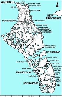
Andros Island is an archipelago within the Bahamas, the largest of the Bahamian Islands. Politically considered a single island, Andros in total has an area greater than all the other 700 Bahamian islands combined. The land area of Andros consists of hundreds of small islets and cays connected by mangrove estuaries and tidal swamplands, together with three major islands: North Andros, Mangrove Cay, and South Andros. The three main islands are separated by "bights", estuaries that trifurcate the island, connecting the island's east and west coasts. It is 167 kilometres (104 mi) long by 64 km (40 mi) wide at the widest point.

Fresh Creek was a district of the Bahamas before 1996. It consisted of the central portion of the island of Andros. The population (1995) was 2,576.

Central Andros is one of the districts of the Bahamas, on Andros Island. Its current Chief Councillor is Mr. Deon Sweeting. The Member of Parliament for this District is Minister Picewell Forbes.

The following is an alphabetical list of topics related to the Commonwealth of The Bahamas.
The Cargill Creek is a tidal creek in Cargill Creek, Central Andros, the Bahamas.
The Deep Creek is a tidal creek in North Andros, the Bahamas.
The Hawk Creek is a river in North Andros, the Bahamas.
The Little Grassy Creek is a tidal creek in South Andros, the Bahamas. Little Grassy Creek is a tributary of Grassy Creek. There are also Grassy Creek Cays.
The Mount Creek is a river North Andros, the Bahamas.
The Pelican Creek is a tidal creek in North Andros, the Bahamas.
The River Lees is a stream in Fresh Creek, Andros Island, The Bahamas.
The Sandy Creek is a [[tidal creek] in North Andros, the Bahamas. It is located northwest of Andros Town and southeast of Owens Town, near Stafford and Staniard Creeks.
The Sapodilla Creek is a tidal creek in North Andros, the Bahamas.
The Simon Creek is a tidal creek in North Andros, the Bahamas.
The Somerset Creek is a tidal creek in North Andros, the Bahamas.
The Staniard Creek is a tidal creek in North Andros, the Bahamas.
The Timber Creek is a tidal creek in North Andros, the Bahamas.
Stafford Creek is a town on North Andros Island in the Bahamas. It is about 3 miles (4.8 km) north of Staniard Creek and about 40 miles (64 km) west of Nassau and about 160 miles (260 km) southeast of Miami. It has a population of 98.

West Side National Park is a national park covering the western half of Andros, the Bahamas, and the surrounding waters. The park was established in 2002 and, after being expanded in 2012, has an area of 1,500,000 acres (6,070 km2), being one of the largest protected areas in the region. The park is regarded as a marine protected area, which includes tidal creeks and coastal mangrove forest, as well as an expansive coastal zone.
