Anse la Raye District is one of 10 districts of the island nation of St. Lucia in the Caribbean Sea. The name Anse la Raye is French for cover/bay of the rays, since there are a large number of skate fish or rays in the bay. In 2005/2010, the population of the district was 6,382/6,060 people, and they are mainly fishers and agricultural workers. The main town in the area takes the same name as the district and is located down the western coast from Castries, the capital of the country.
The battle of Wytyczno took place on October 1, 1939 near the village of Wytyczno near Włodawa in Poland. It was a struggle between the Polish forces of the Border Defence Corps of Gen. Wilhelm Orlik-Rückemann and the Soviet Red Army during the invasion of Poland.
Shuswap Lake Marine Provincial Park is a provincial park in British Columbia, Canada, comprising 894 ha. The Park has a variety of amenities including boat launch ramps, picnic areas, and 27 campsites around the perimeter of Shuswap Lake. The lake's name and that of the surrounding Shuswap Country is from the Shuswap people (Secwepemc), the most northern of the Salishan speaking people.
The Upper Similkameen Indian Band or Upper Smelqmix, is a First Nations band government in the Canadian province of British Columbia, whose head offices are located in town of Hedley in the Similkameen Country. They are a member of the Okanagan Nation Alliance.
The Stone First Nation or Yunesit'in First Nation is a band government of the Yunesit'in subgroup of the Tsilhqot'in people, whose territory is the Chilcotin District in the western Central Interior region of the Canadian province of British Columbia. It is a member of the Tsilhqot'in Tribal Council. The people of the Stone First Nation are known as the Yunesit'in in the Chilcotin language.
The Valenciennes River is a tributary of the Bush River, entering that river just above its mouth into Kinbasket Lake, the reservoir on the Columbia River created by the Mica Dam in southeastern British Columbia, Canada. The Valenciennes was originally known as the South Fork Bush River. Headwaters form on the south slope of Valenciennes Mountain. Approximately halfway through the course of the river, the Valenciennes receives Icefall Brook on the right, flowing South from Cerberus Falls.

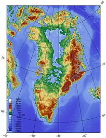
Akuliarusiarsuup Kuua is a river and valley of the same name in the Qeqqata municipality in central-western Greenland. Its source is the meltwater outflow from Russell Glacier, an outflow of the Greenland ice sheet. The river is a tributary of Qinnguata Kuussua, the main river in the Kangerlussuaq area. For most of its run, the river flows very slowly through the sandur basin of the valley, forming meanders amongst large fields of glacial silt quicksand. The climate is polar continental, with the area receiving very little rainfall.
Aajuitsup Tasia is a large lake in central-western Greenland, in the Qeqqata municipality. It is located approximately 12 km (7.5 mi) northeast of Kangerlussuaq. It is of elongated oval shape, with its western shore at 67°04′45″N50°30′02″W and its eastern shore at 67°05′35″N50°16′30″W. Aajuitsup Tasia is an oligotrophic lake of 32 m (105 ft) depth, covering an area of 1,350ha.

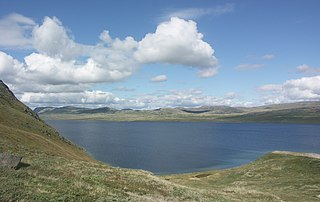
Sanningasoq is a large oligotrophic twin lake in central-western Greenland, in the Qeqqata municipality. It is located approximately 9 km (5.6 mi) northeast of Kangerlussuaq. It is characteristic in that it is composed of two lakes connected via a narrow water passage through a broken isthmus. Its northwestern shore is at 67°05′15″N50°39′50″W and its southeastern shore at 67°04′00″N50°28′53″W.

Qinnguata Kuussua is a river in a valley of the same name in the Qeqqata municipality in central-western Greenland. Its source is a large meltwater outflow from Russell Glacier flowing from the Greenland Ice Sheet. It is the main river in the Kangerlussuaq area. For most of its run, the river is very wide, up to 2 km (1.2 mi) in the upper reaches. The climate is polar continental, with the area receiving very little rainfall.

Bluie was the United States military code name for Greenland during World War II. It is remembered by the numbered sequence of base locations identified by the 1941 United States Coast Guard South Greenland Survey Expedition, and subsequently used in radio communications by airmen unfamiliar with pronunciation of the Inuit and Old Norse names of those locations. These were typically spoken BLUIE (direction) (number), with direction being east or west along the Greenland coast from Cape Farewell.
Kangerlussuaq Fjord is a long fjord in the Qeqqata municipality in central-western Greenland. The fjord is 190 km (120 mi) long and between 1.5 km (0.93 mi) and 8 km (5.0 mi) wide, flowing from the estuary of Qinnguata Kuussua river to the southwest, and emptying into the Davis Strait. It is the longest fjord of western Greenland.
Tunulliarfik Fjord is a fjord near Qaqortoq in the Kujalleq municipality in southern Greenland. It is the inner section of Skovfjord (Skovfjorden). In times of the Norse settlement in southern Greenland, it was known as Eiriksfjord.

Majorqaq is a meltwater river and valley of the same name in the Qeqqata municipality in central-western Greenland. It is one of the widest rivers in western Greenland, draining the Greenland ice sheet.
Isortoq Fjord is a fjord in the Qeqqata municipality in western Greenland. The fjord to the east of Maniitsoq, emptying into Davis Strait. Majorqaq, one of the widest rivers in western Greenland draining the Greenland ice sheet, empties into the fjord head.
Qorlortorsuaq Dam is a hydroelectric dam near Qorlortorsuaq in the Nanortalik district of the Kujalleq municipality in southern Greenland. It has a capacity of 7.2 MW and it generates power for the neighbouring towns of Qaqortoq and Narsaq.
The Battle of Raciborz took place in the Polish town of Raciborz, on 20 March 1241, during the Mongol invasion of Poland. It ended in the victory of a Polish army from Silesia, commanded by Duke of Opole and Raciborz, Mieszko II the Fat.