
Grenada is an island country located between the Caribbean Sea and Atlantic Ocean, north of Trinidad and Tobago. It is located at 12°07′N61°40′W. There are no large inland bodies of water on the island, which consists entirely of the state of Grenada. The coastline is 121 km long. The island has 15 constituencies and speaks English and Grenadian Creole. It is volcanic in origin and its topography is mountainous.
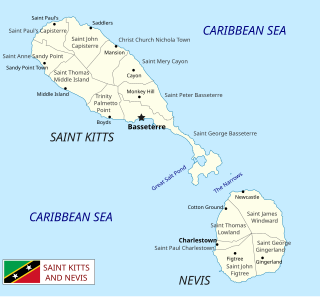
Saint Kitts and Nevis is a twin island country with a total landmass of just 270 square kilometres (104 sq mi). The island of St. Kitts, the larger of the two, is 180 square kilometres (68 sq mi) in size and is located at latitude 17.30 N, and longitude 62.80 W. Nevis is 93 square kilometres (36 sq mi) and located at latitude 17.10 N, longitude 62.35 W, approximately 3 km south-east of St. Kitts. The islands are about one-third of the way from Puerto Rico to Trinidad and Tobago. The islands are volcanic and mountainous.
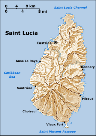
Saint Lucia is one of many small land masses composing the insular group known as the Windward Islands. Unlike large limestone areas such as Florida, Cuba, and the Yucatan Peninsula, or the Bahamas, which is a small island group composed of coral and sand, Saint Lucia is a typical Windward Island formation of volcanic rock that came into existence long after much of the region had already been formed.

Saint Vincent and the Grenadines is an island state in the Windward Islands of the Lesser Antilles, an island arc of the Caribbean Sea in North America. The country consists of the main island of Saint Vincent and the northern two-thirds of the Grenadines, a chain of small islands stretching south from Saint Vincent to Grenada. Its total land area is 390 km2 of which 342.7 km2 is the main island of Saint Vincent. The country's capital is at Kingstown on Saint Vincent.

Bridgetown is the capital and largest city of Barbados. Formerly The Town of Saint Michael, the Greater Bridgetown area is located within the parish of Saint Michael. Bridgetown is sometimes locally referred to as "The City", but the most common reference is simply "Town". As of 2014, its metropolitan population stands at roughly 110,000.

Barbados is a continental island in the North Atlantic Ocean and is located at 13°10' north of the equator, and 59°32' west of the Prime Meridian. As the easternmost isle of the Lesser Antilles in the West Indies, Barbados lies 160 kilometres (100 mi) east of the Windward Islands and Caribbean Sea. The maritime claim for Barbados is a territorial sea of 12 nmi, with an exclusive economic zone of 200 nmi which gives Barbados a total maritime area of 186,898 km2 (72,162 sq mi). Of the total EEZ area, 70,000 km2 is set aside for offshore oil exploration. A pending application to UNCLOS has placed for consideration a continental shelf 200 nmi to the east and south. To the west, most of Barbados' maritime boundaries consist of median lines with neighbours. These neighbours include: Martinique, and Saint Lucia to the northwest, Saint Vincent and the Grenadines to the west, Trinidad and Tobago and Venezuela to the southwest, and Guyana to the southeast.

The Lesser Antilles are a group of islands in the Caribbean Sea. They are distinguished from the large islands of the Greater Antilles to the west. They form an arc which begins east of Puerto Rico and swings south through the Leeward and Windward Islands almost to South America and then turns west along the Venezuelan coast as far as Aruba. Barbados is isolated about 100 miles east of the Windwards.

The Antilles is an archipelago bordered by the Caribbean Sea to the south and west, the Gulf of Mexico to the northwest, and the Atlantic Ocean to the north and east.
The Windward Islands are the southern, generally larger islands of the Lesser Antilles. Part of the West Indies, they lie south of the Leeward Islands, approximately between latitudes 10° and 16° N and longitudes 60° and 62° W.

The parish of Christ Church is one of eleven historic political divisions of Barbados. It has a land area of 57 km2 (22 sq mi) and is found at the southern end of the island. Christ Church has survived by name as one of the original six parishes created in 1629 by Governor Sir William Tufton.

The 1917 Atlantic hurricane season featured nine known tropical cyclones, four of which became tropical storms. The first system appeared on July 6 east of the Windward Islands. After crossing the islands and traversing the Caribbean Sea, the storm struck Honduras, Belize, and Mexico, before dissipating on July 14. After more than three weeks without tropical cyclogenesis, another tropical storm developed west of Bermuda. As the storm brushed eastern New England, four ships sank near Nantucket, causing 41 fatalities. The same cyclone brought damaging winds to Nova Scotia before transitioning into an extratropical cyclone on August 10.

Charlotte is the largest parish of Saint Vincent and the Grenadines, situated on the eastern coast of the island of Saint Vincent. With an area of 149 km², its size is comparable to that of the British Virgin Islands. It’s the country‘s largest parish by area and the second most populous one. The parish has the longest coastline of all the parishes and is also larger than the three smallest parishes combined. The parish possesses a very rough and rugged topography with very little flat land occurring towards the coast. as a result of these features, parts of the north of the parish cannot be accessed by a main road. Up until the building of a bridge over the Rabacca Dry River access to the north side of the river was not possible when rain caused the river to swell and make the path impassable.

The Windward Islands Hurricane was a strong, destructive hurricane that raged through the eastern Caribbean islands in the early part of September during the 1898 Atlantic hurricane season. An estimated 392 people died as a result of the storm. Damage on Barbados and St. Vincent was catastrophic.

The West Indies is a subregion of North America, surrounded by the North Atlantic Ocean and the Caribbean Sea, which comprises 13 independent island countries and 19 dependencies in three archipelagos: the Greater Antilles, the Lesser Antilles, and the Lucayan Archipelago.

The following outline is provided as an overview of and introduction to Barbados:

The 1855 Atlantic hurricane season featured tropical cyclone landfalls in the Gulf Coast of the United States, the Greater Antilles, and Mexico, but none along the East Coast of the United States. It was inactive, with only five known tropical cyclones. Another tropical storm was believed to have existed offshore Atlantic Canada in late August and early September, but HURDAT – the official Atlantic hurricane database – now excludes this system. The first known system was initially observed on August 5, while the final known storm was last noted on September 17. These dates fall within the period with the most tropical cyclone activity in the Atlantic. At one point during the season, two tropical cyclones existed simultaneously. Two of the cyclones only have a single known point in their tracks due to a sparsity of data.

