Related Research Articles
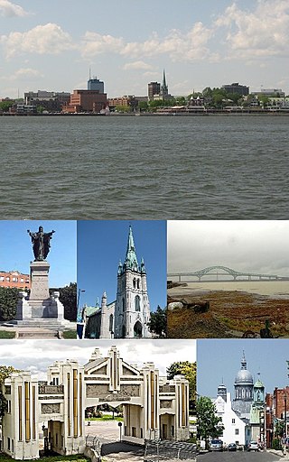
Trois-Rivières is a city in the Mauricie administrative region of Quebec, Canada, at the confluence of the Saint-Maurice and Saint Lawrence rivers, on the north shore of the Saint Lawrence River across from the city of Bécancour. It is part of the densely populated Quebec City–Windsor Corridor and is approximately halfway between Montreal and Quebec City. Trois-Rivières is the economic and cultural hub of the Mauricie region. The settlement was founded by French colonists on July 4, 1634, as the second permanent settlement in New France, after Quebec City in 1608.
The Rivière des Prairies, called the Back River in English, is a delta channel of the Ottawa River in southwestern Quebec, Canada. The Kanien'kehá:ka called it Skowanoti, meaning "River behind the island". The river separates the cities of Laval and Montreal.

Rivière-du-Loup is a small city on the south shore of the Saint Lawrence River in Quebec. The city is the seat for the Rivière-du-Loup Regional County Municipality and the judicial district of Kamouraska. Its one of the largest cities in Bas-Saint-Laurent.

La Rivière-du-Nord is a regional county municipality in the Laurentides region of Quebec, Canada. The seat is in Saint-Jérôme. It is named for the river that runs through it, the Rivière du Nord.

Mékinac is a regional county municipality (MRC) in the administrative region of Mauricie, in the province of Quebec, Canada. Its seat is Saint-Tite. It is composed of 10 municipalities and 4 unorganized territories.

Rivière-du-Loup is a regional county municipality in the Bas-Saint-Laurent region of Quebec, Canada. Its most important city is Rivière-du-Loup, which contains more than half of the population.

Sept-Rivières is a regional county municipality of Quebec, Canada, in the Côte-Nord region. Its county seat is Sept-Îles.

Les Chenaux is a regional county municipality in central Quebec, Canada, in the Mauricie region. The seat is in Saint-Luc-de-Vincennes. It is located adjacent on the east of Trois-Rivières on the Saint Lawrence River. It has a land area of 872.04 square kilometres (336.70 sq mi) and a population of 17,865 inhabitants in the Canada 2011 Census. Its largest community is the parish of Notre-Dame-du-Mont-Carmel.

Halls Stream or Rivière Hall is a 25.2-mile-long (40.6 km) tributary of the Connecticut River in eastern North America. For most of its length, it forms the Canada–United States border, with the province of Quebec (Canada) to its west and the state of New Hampshire to its east.

The St. Francis River is a river roughly 75 miles (120 km) long, which forms part of the Canada–United States border. The river rises in a lake of the same name located 12 miles (20 km) east of the Rivière du Loup in Quebec. The portion that forms the boundary starts at the bottom of Lake Pohenegamook at the very northernmost point of New England between Estcourt Station, Maine, and Estcourt, Quebec. The river along the international boundary flows south and then south-east through two deep, narrow lakes to its mouth on the Saint John River at St. Francis, Maine/Saint-François-de-Madawaska, New Brunswick.

Rivière-Bleue is a municipality in Quebec with more or less 1500 inhabitants. The municipality is located in the Bas-Saint-Laurent region on the border of the province of New-Brunswick and Canada–United States border with Maine.

Lac-Ashuapmushuan is an unorganized territory in the Canadian province of Quebec, Canada, located in the regional county municipality of Le Domaine-du-Roy. The region had a population of 140 as of the Canada 2021 Census, and covered a land area of 14,684.28 km2. It is home to the Ashuapmushuan Wildlife Reserve.
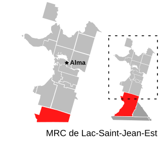
Belle-Rivière is an unorganized territory in the Canadian province of Quebec, located in the regional county municipality of Lac-Saint-Jean-Est. It had a population of 10 in the Canada 2021 Census, and covered a land area of 608.47 km2. The Métabetchouane River forms its western boundary.
Rivière-Nipissis is an unorganized territory in the Côte-Nord region of Quebec, Canada, part of the Sept-Rivières Regional County Municipality.