
Andros Island is an archipelago within the Bahamas, the largest of the Bahamian Islands. Politically considered a single island, Andros in total has an area greater than all the other 700 Bahamian islands combined. The land area of Andros consists of hundreds of small islets and cays connected by mangrove estuaries and tidal swamplands, together with three major islands: North Andros, Mangrove Cay, and South Andros. The three main islands are separated by "bights", estuaries that trifurcate the island, connecting the island's east and west coasts. It is 167 kilometres (104 mi) long by 64 km (40 mi) wide at the widest point.
Deep or The Deep may refer to:

Eleuthera refers both to a single island in the archipelagic state of The Commonwealth of the Bahamas and to its associated group of smaller islands. Eleuthera forms a part of the Great Bahama Bank. The island of Eleuthera incorporates the smaller Harbour Island. "Eleuthera" derives from the feminine form of the Greek adjective ἐλεύθερος (eleútheros), meaning "free". Known in the 17th century as Cigateo, it lies 80 km east of Nassau. It is long and thin—180 km long and in places little more than 1.6 km wide. Its eastern side faces the Atlantic Ocean, and its western side faces the Great Bahama Bank. The topography of the island varies from wide rolling pink sand beaches to large outcrops of ancient coral reefs, and its population is approximately 11,000. The principal economy of the island is tourism.

Freeport is a city, district and free trade zone on the island of Grand Bahama of the northwest Bahamas. In 1955, Wallace Groves, a Virginian financier with lumber interests in Grand Bahama, was granted 20,000 hectares of pineyard with substantial areas of swamp and scrubland by the Bahamian government with a mandate to economically develop the area. Freeport has grown to become the second most populous city in the Bahamas.

A tidal creek or tidal channel is a narrow inlet or estuary that is affected by ebb and flow of ocean tides. Thus it has variable salinity and electrical conductivity over the tidal cycle, and flushes salts from inland soils. Tidal creeks are characterized by slow water velocity resulting in buildup of fine, organic sediment in wetlands. Creeks may often be a dry to muddy channel with little or no flow at low tide, but with significant depth of water at high tide. Due to the temporal variability of water quality parameters within the tidally influenced zone, there are unique biota associated with tidal creeks which are often specialised to such zones. Nutrients and organic matter are delivered downstream to habitats normally lacking these, while the creeks also provide access to inland habitat for salt-water organisms.

The Black Seminoles or Afro-Seminoles are black Indians associated with the Seminole people in Florida and Oklahoma. They are mostly blood descendants of the Seminole people, free blacks and of escaped slaves who allied with Seminole groups in Spanish Florida. Many have Seminole lineage, but due to the stigma of having dark skin, they all have been categorized as slaves or freedmen.

Woodbine is an unincorporated rural community in Howard and Carroll counties, Maryland, United States. It is part of the Baltimore metropolitan area. It is located southeast of Frederick, west of Baltimore, north of Washington, D.C., and east of Mount Airy. The community was named for the woodbine plant, which grew in the community in fields and along riverbanks.
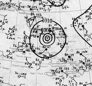
The 1929 Bahamas hurricane was a high-end Category 4 tropical cyclone whose intensity and slow forward speed led to catastrophic damage in the Bahamas in September 1929, particularly on Andros and New Providence islands. Its erratic path and a lack of nearby weather observations made the hurricane difficult to locate and forecast. The storm later made two landfalls in Florida, killing eleven but causing comparatively light damage. Moisture from the storm led to extensive flooding over the Southeastern United States, particularly along the Savannah River. Across its path from the Bahamas to the mouth of the Saint Lawrence River, the hurricane killed 155 people.

The State of Muskogee was a proclaimed sovereign nation located in Florida, founded in 1799 and led by William Augustus Bowles, a Loyalist veteran of the American Revolutionary War who lived among the Muscogee, and envisioned uniting the American Indians of the Southeast into a single nation that could resist the expansion of the United States. Bowles enjoyed the support of the Miccosukee (Seminole) and several bands of Muscogee. He envisioned his state as eventually growing to encompass the Cherokee, Upper and Lower Creeks, Choctaw, and Chickasaw, in parts of present-day Georgia and Alabama.

The following is an alphabetical list of topics related to the Commonwealth of The Bahamas.
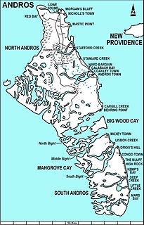
The Cargill Creek is a tidal creek in Cargill Creek, Central Andros, the Bahamas.
The Deep Creek is a tidal creek in North Andros, the Bahamas.
The Hawk Creek is a river in North Andros, the Bahamas.
The Sandy Creek is a [[tidal creek] in North Andros, the Bahamas. It is located northwest of Andros Town and southeast of Owens Town, near Stafford and Staniard Creeks.
The Simon Creek is a tidal creek in North Andros, the Bahamas.
The Somerset Creek is a tidal creek in North Andros, the Bahamas.
The Staniard Creek is a tidal creek in North Andros, the Bahamas.
Stafford Creek is a town on North Andros Island in the Bahamas. It is about 3 miles (4.8 km) north of Staniard Creek and about 40 miles (64 km) west of Nassau and about 160 miles (260 km) southeast of Miami. It has a population of 98.
