
The Bahamas, officially the Commonwealth of The Bahamas, is a country within the Lucayan Archipelago of the West Indies in the Atlantic. It takes up 97% of the Lucayan Archipelago's land area and is home to 88% of the archipelago's population. The archipelagic state consists of more than 3,000 islands, cays, and islets in the Atlantic Ocean, and is located north of Cuba and northwest of the island of Hispaniola and the Turks and Caicos Islands, southeast of the U.S. state of Florida, and east of the Florida Keys. The capital is Nassau on the island of New Providence. The Royal Bahamas Defence Force describes The Bahamas' territory as encompassing 470,000 km2 (180,000 sq mi) of ocean space.

Minnetonka is a suburban city in Hennepin County, Minnesota, United States, about 9 miles (14 km) west of Minneapolis. The name comes from the Dakota Sioux mni tanka, meaning "great water". U.S. Highway 12 is the city’s main road.

Andros Island is an archipelago within the Bahamas, the largest of the Bahamian Islands. Politically considered a single island, Andros in total has an area greater than all the other 700 Bahamian islands combined. The land area of Andros consists of hundreds of small islets and cays connected by mangrove estuaries and tidal swamplands, together with three major islands: North Andros, Mangrove Cay, and South Andros. The three main islands are separated by "bights", estuaries that trifurcate the island from east to west. It is 167 kilometres (104 mi) long by 64 km (40 mi) wide at the widest point.

Eleuthera refers both to a single island in the archipelagic state of The Commonwealth of the Bahamas and to its associated group of smaller islands. Eleuthera forms a part of the Great Bahama Bank. The island of Eleuthera incorporates the smaller Harbour Island. "Eleuthera" derives from the feminine form of the Greek adjective ἐλεύθερος (eleútheros), meaning "free". Known in the 17th century as Cigateo, it lies 80 km east of Nassau. It is long and thin—180 km long and in places little more than 1.6 km wide. Its eastern side faces the Atlantic Ocean, and its western side faces the Great Bahama Bank. The topography of the island varies from wide rolling pink sand beaches to large outcrops of ancient coral reefs, and its population is approximately 11,000. The principal economy of the island is tourism.

Cat Island is located in central Bahamas, and is one of its districts. Cat Island also has the nation's highest point, Mount Alvernia. It rises to 63 metres (207 ft) and is topped by a monastery called The Hermitage. This assembly of buildings was erected by the Franciscan "Brother Jerome".

Cargill, Incorporated is a privately held American global food corporation based in Minnetonka, Minnesota, and incorporated in Wilmington, Delaware. Founded in 1865, it is the largest privately held corporation in the United States in terms of revenue. If it were a public company, it would rank, as of 2015, number 15 on the Fortune 500, behind McKesson and ahead of AT&T. Cargill has frequently been the subject of criticism related to the environment, human rights, finance, and other ethical considerations.

Freeport is a city, district and free trade zone on the island of Grand Bahama of the northwest Bahamas. In 1955, Wallace Groves, a Virginian financier with lumber interests in Grand Bahama, was granted 20,000 hectares of pineyard with substantial areas of swamp and scrubland by the Bahamian government with a mandate to economically develop the area. Freeport has grown to become the second most populous city in the Bahamas.

Inagua is the southernmost district of the Bahamas, comprising the islands of Great Inagua and Little Inagua. The headquarters for the district council are in Matthew Town.
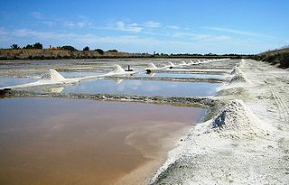
A salt evaporation pond is a shallow artificial salt pan designed to extract salts from sea water or other brines. Natural salt pans are geological formations that are also created by water evaporating and leaving behind salts. Some salt evaporation ponds are only slightly modified from their natural version, such as the ponds on Great Inagua in the Bahamas, or the ponds in Jasiira, a few kilometres south of Mogadishu, where seawater is trapped and left to evaporate in the sun.

East Grand Bahama is a district of the Bahamas, situated on the eastern part of the island of Grand Bahama.

South Andros is a district of the nation of the Bahamas.

North Andros is one of the 31 districts of the Bahamas. It is also the largest district in the country. It has some of the largest settlements on Andros Island and many churches as well. The population is 3,898.
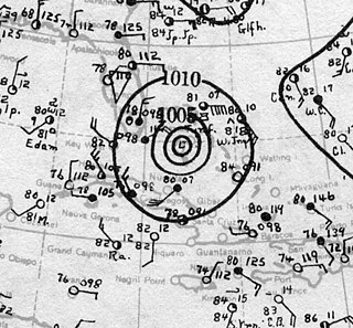
The 1929 Bahamas hurricane was a high-end Category 4 tropical cyclone whose intensity and slow forward speed led to catastrophic damage in the Bahamas in September 1929, particularly on Andros and New Providence islands. Its erratic path and a lack of nearby weather observations made the hurricane difficult to locate and forecast. The storm later made two landfalls in Florida, killing eleven but causing comparatively light damage. Moisture from the storm led to extensive flooding over the Southeastern United States, particularly along the Savannah River. Across its path from the Bahamas to the mouth of the Saint Lawrence River, the hurricane killed 155 people.

Paradise Valley is a major river valley of the Yellowstone River in southwestern Montana just north of Yellowstone National Park in Park County, Montana. The valley is flanked by the Absaroka Range on the east and the Gallatin Range on the west.
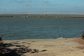
Westpoint Slough is the largest of several sloughs feeding into Redwood Creek in San Mateo County, California, United States. This slough is surrounded by extensive undisturbed marshlands including Greco Island, which forms its northern boundary. The channel of Westpoint Slough contains considerable mudflat areas; moreover, both the marshes and mudflats offer considerable habitat area for local and migratory wildlife, especially birds.
Cargill is a privately held American multinational corporation.

The following is an alphabetical list of topics related to the Commonwealth of The Bahamas.
Marion Hamilton MacMillan Pictet was an American heiress.

Jade Cargill is an American professional wrestler currently signed to All Elite Wrestling (AEW), where she is the current and inaugural AEW TBS Champion.

