
Nassau is the capital and largest city of The Bahamas. With a population of 274,400 as of 2016, or just over 70% of the entire population of The Bahamas, Nassau is commonly defined as a primate city, dwarfing all other towns in the country. It is the centre of commerce, education, law, administration, and media of the country.

New Providence is the most populous island in The Bahamas, containing more than 70% of the total population. It is the location of the national capital city of Nassau, whose boundaries are coincident with the island; it had a population of 246,329 at the 2010 Census; the latest estimate (2016) is 274,400.
The Berry Islands are a chain of islands and a district of the Bahamas, covering about thirty square miles (78 km2) of the northwestern part of the Out Islands.

San Salvador Island is an island and district of The Bahamas. It is widely believed that during Christopher Columbus's first expedition to the New World, this island was the first land he sighted and visited on 12 October 1492. He named it San Salvador after Christ the Saviour. Columbus's records indicate that the native Lucayan inhabitants of the territory, who called their island Guanahani, were "sweet and gentle".

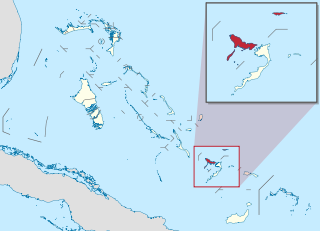
The Abaco Islands lie in the northern Bahamas. The main islands are Great Abaco and Little Abaco. There are several smaller barrier cays, of which the northernmost are Walker's Cay and its sister island Grand Cay. To the south, the next inhabited islands are Spanish Cay and Green Turtle Cay, with its settlement of New Plymouth, Great Guana Cay, private Scotland Cay, Man-O-War Cay, and Elbow Cay, with its settlement of Hope Town. Southernmost are Tilloo Cay and Lubbers Quarters. Another of note off Abaco's western shore is Gorda Cay, now a Disney-owned island and a cruise ship stop renamed Castaway Cay. Also in the vicinity is Moore's Island. On the Big Island of Abaco is Marsh Harbour, the Abacos' commercial hub and the Bahamas' third largest city, plus the resort area of Treasure Cay. Both have airports. A few mainland settlements of significance are Coopers Town and Fox Town in the north and Cherokee and Sandy Point in the south. Administratively, the Abaco Islands constitute seven of the 31 Local Government Districts of the Bahamas: Grand Cay, North Abaco, Green Turtle Cay, Central Abaco, South Abaco, Moore's Island, and Hope Town.

Grand Bahama is the northernmost of the islands of the Bahamas, with the town of West End located 56 nautical miles east of Palm Beach, Florida. It is the third largest island in the Bahamas island chain of approximately 700 islands and 2,400 cays. The island is roughly 530 square miles (1,400 km2) in area and approximately 153 kilometres (95 mi) long west to east and 24 kilometres (15 mi) at its widest point north to south. Administratively, the island consists of the Freeport Bonded Area and the districts of East Grand Bahama and West Grand Bahama. Nearly half of the homes on the island were damaged or destroyed in early September 2019 by Hurricane Dorian.

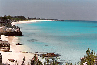
Eleuthera refers both to a single island in the archipelagic state of The Commonwealth of the Bahamas and to its associated group of smaller islands. Eleuthera forms a part of the Great Bahama Bank. The island of Eleuthera incorporates the smaller Harbour Island. "Eleuthera" derives from the feminine form of the Greek adjective ἐλεύθερος (eleútheros), meaning "free". Known in the 17th century as Cigateo, it lies 80 km east of Nassau. It is long and thin—180 km long and in places little more than 1.6 km wide. Its eastern side faces the Atlantic Ocean, and its western side faces the Great Bahama Bank. The topography of the island varies from wide rolling pink sand beaches to large outcrops of ancient coral reefs, and its population is approximately 11,000. The principal economy of the island is tourism.

Exuma is a district of The Bahamas, consisting of over 365 islands, also called cays.
Crooked Island is an island and district, part of a group of Bahamian islands defining a large, shallow lagoon called the Bight of Acklins, of which the largest are Crooked Island in the north and Acklins in the south-east, and the smaller are Long Cay in the north-west, and Castle Island in the south.
Harbour Island is an island and administrative district in the Bahamas and is located off the northeast coast of Eleuthera Island. It has a population of 1,762.
Coopers Town is a village in Abaco, the second largest island of the Bahamas. It has a population of 676.
Marsh Harbour is a town in Abaco Islands, Bahamas, with a population of 6,283 as of 2012.
Man-O-War Cay is a small island in the Abaco region of the Bahamas. It had a population of 215 at the 2010 census.

Mangrove Cay is one of the districts of the Bahamas, on Andros Island. Its capital is Moxey Town in the north east corner of the island.

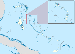
North Abaco is one of the districts of the Bahamas, on the Abaco Islands. It has a population of 9,578 according to the 2010 census.

Spanish Wells is a district of the Bahamas. The settlement consists of a medium-sized town on the island of St. George's Cay 610 m (2,000 ft) wide by 2,860 m (9,380 ft) long, located approximately 500 m (1,600 ft) off the northern tip of Eleuthera island. According to the 2010 census, it has a population of 1,551 residents.
Treasure Cay, is a parcel of land connected to Great Abaco Island in the Bahamas. It has a population of 1,187.(2010 census)
Spring City is a town in the Abaco Islands, Bahamas. It is almost directly south of Marsh Harbour. It is also a part of the Marsh Harbour-Spring City Township. It is located 4 meters above sea-level, making it prone to global warming. As of 2010, its population was 500.
Man Island is a small, undeveloped island located near Eleuthera in the Bahamas Islands. Man Island is located in a group of islands that form a natural harbor and the largest island in this chain is Harbour Island. Man Island is situated between Harbour Island and the island of Spanish Wells.

Long Island is an island in The Bahamas that is split by the Tropic of Cancer. It is one of the Districts of the Bahamas and is known as the most scenic island in the Bahamas. Its capital is Clarence Town. The population of Long Island is 3,094 inhabitants.
