
The Bahamas, officially the Commonwealth of The Bahamas, is an island country within the Lucayan Archipelago of the Atlantic Ocean. It contains 97% of the Lucayan Archipelago's land area and 88% of its population. The archipelagic country consists of more than 3,000 islands, cays, and islets in the Atlantic Ocean, and is located north of Cuba and northwest of the island of Hispaniola and the Turks and Caicos Islands, southeast of the U.S. state of Florida, and east of the Florida Keys. The capital is Nassau on the island of New Providence. The Royal Bahamas Defence Force describes the Bahamas' territory as encompassing 470,000 km2 (180,000 sq mi) of ocean space.
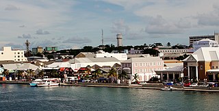
Nassau is the capital and largest city of the Bahamas. It is located on the island of New Providence, which had a population of 246,329 in 2010, or just over 70% of the entire population of the Bahamas. As of April 2023, the preliminary results of the 2022 census of the Bahamas reported a population of 296,522 for New Providence, 74.26% of the country's population. Nassau is commonly defined as a primate city, dwarfing all other towns in the country. It is the centre of commerce, education, law, administration, and media of the country.
New Providence is the most populous island in The Bahamas, containing more than 70% of the total population. On the eastern side of the island is the national capital city of Nassau; it had a population of 246,329 at the 2010 Census, and a population of 292,522 at the 2022 census. Nearly three quarters of The Bahamas's population lives in New Providence.
The Berry Islands are a chain of islands and a district of the Bahamas, covering about thirty square miles (78 km2) of the northwestern part of the Out Islands.

Andros Island is an archipelago within The Bahamas, the largest of the Bahamian Islands. Politically considered a single island, Andros in total has an area greater than all the other 700 Bahamian islands combined. The land area of Andros consists of hundreds of small islets and cays connected by mangrove estuaries and tidal swamplands, together with three major islands: North Andros, Mangrove Cay, and South Andros. The three main islands are separated by bights, estuaries that trifurcate the island from east to west. It is 167 kilometres (104 mi) long by 64 km (40 mi) wide at the widest point.

Local government in the Bahamas exists at two levels: 32 districts and 41 towns. The boundaries of districts are defined by the First Schedule of The Bahamas Local Government Act 1996, defined with reference to parliamentary constituency boundaries. The Second Schedule lists 13 districts which are divided into town areas. Towns are governed by directly elected town committees. Second Schedule districts are governed by nine-person district councils composed of the chairs of the town committees, and if numerically required, additional people elected by the town committees. The 19 Third Schedule districts are unitary authorities which cannot be divided into towns. They are governed by nine-person district councils which are directly elected by voters. The powers of Second Schedule and Third Schedule councils are slightly different, and the Third Schedule district known as the City of Freeport has a slightly different list of enumerated powers.
Nichollstown and Berry Islands was a district of the Bahamas. It included the northern portion of the island of Andros, with a population of 3,444 in the year 2000, as well as the nearby Berry Islands, which had a population of 809 at that time [1]. Since 1996, the Berry Islands have been established as a separate district, while the Nichollstown area has been redefined as part of the district of North Andros [2].

South Andros is a district of the nation of the Bahamas.

Mangrove Cay is one of the districts of the Bahamas, on Andros Island. The capital of Mangrove Cay is Moxey Town in the northeast corner of the island.

North Andros is one of the 31 districts of the Bahamas. It is also the largest district in the country. It has some of the largest settlements on Andros Island and many churches as well. The population is 4,069.

Runaway Bay is a town in Saint Ann Parish on the northern coast of Jamaica and is considered one of the most naturally beautiful places on the island. It is a notable tourist destination located 16 km (9.9 mi) west of Ocho Rios, and slightly east of Discovery Bay, where Christopher Columbus landed in 1494. Ocean View Beach is a private beach situated at Runaway Bay. It consists of a series of hotel resort complexes and beaches.

The following is an alphabetical list of topics related to the Commonwealth of The Bahamas.
Andros Town is a town in North Andros and capital of Andros Island in the Bahamas.
Congo Town is a small village located in South Andros district, part of Andros Island in the Bahamas.

Afro-Bahamians are an ethnicity originating in The Bahamas of predominantly or partial native African descent. They are descendants of various African ethnic groups, many associated with the Bight of Biafra, Ghana, Songhai and Mali, the various Fula kingdoms, the Oyo Empire, and the Kingdom of Kongo. According to the 2010 census, 92.7% of The Bahamas' population identifies as mixed African descent.
White Bahamians are Bahamian citizens of European ancestry, most of whom trace their ancestry back to England, Scotland and Ireland. Bahamians of European descent are sometimes called "Conchs", a term that is also applied to people of White Bahamian descent in Florida. White Bahamians were a majority in the 18th century, but now constitute less than 10% of the Bahamian population.

Sir Edward Nicolls was an Anglo-Irish officer of the Royal Marines. Known as "Fighting Nicolls", he had a distinguished military career. According to his obituary in The Times, he was "in no fewer than 107 actions, in various parts of the world", and had "his left leg broken and his right leg severely injured, was shot through the body and right arm, had received a severe sabre cut in the head, was bayoneted in the chest, and had lost the sight of an eye."

Stafford Creek is a town on North Andros Island in the Bahamas. It is about 3 miles (4.8 km) north of Staniard Creek and about 40 miles (64 km) west of Nassau and about 160 miles (260 km) southeast of Miami. In 2010, the town had a population of 98.

Long Island is an island in The Bahamas that is split by the Tropic of Cancer. It is one of the Districts of the Bahamas and is known as the most scenic island in the Bahamas. Its capital is Clarence Town. The population of Long Island is 3,094 inhabitants.

Slavery in Florida occurred among indigenous tribes and during Spanish rule. Florida's purchase by the United States from Spain in 1819 was primarily a measure to strengthen the system of slavery on Southern plantations, by denying potential runaways the formerly safe haven of Florida. Florida became a slave state, seceded, and passed laws to exile or enslave free blacks. Even after abolition, forced labor continued.
