Districts of Belize

Last updated

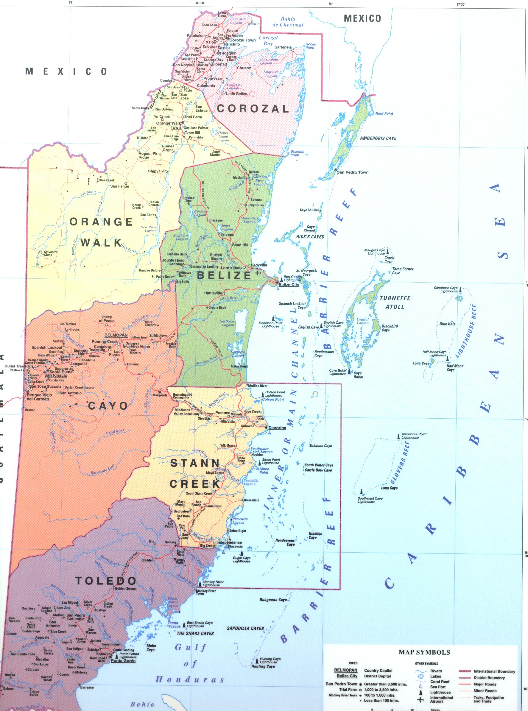
Belize is divided into six districts: Belize, Cayo, Corozal, Orange Walk, Stann Creek and Toledo.

Contents

List

Districts of Belize Belize, administrative divisions - en - monochrome.svg
Districts of Belize

DistrictCapitalArea [1] Population
(2019) [2]
Population
(2010) [1]
ChangePopulation density
(2019)
Belize Belize City 4,310 km2 (1,663 sq mi)124,09695,292+30.2%
Cayo San Ignacio 5,200 km2 (2,006 sq mi)99,11875,046+32.1%
Corozal Corozal Town 1,860 km2 (718 sq mi)49,44641,061+20.4%
Orange Walk Orange Walk Town 4,600 km2 (1,790 sq mi)52,55045,946+14.4%
Stann Creek Dangriga 2,550 km2 (986 sq mi)44,72034,324+30.3%
Toledo Punta Gorda 4,410 km2 (1,704 sq mi)38,55730,785+25.2%

See also

Related Research Articles

<span class="mw-page-title-main">Belize</span> Country in Central America

Belize is a country on the north-eastern coast of Central America. It is bordered by Mexico to the north, the Caribbean Sea to the east, and Guatemala to the west and south. It also shares a water boundary with Honduras to the southeast. Belize is a member of CARICOM - Caribbean Community, and is considered part of the Caribbean region and the historical British West Indies.

<span class="mw-page-title-main">Demographics of Belize</span>

Demographics of the population of Belize include population density, ethnicity, education level, health of the populace, economic status, religious affiliations and other aspects.

<span class="mw-page-title-main">Belize City</span> Largest city in Belize

Belize City is the largest city in Belize. It was once the capital of the former British Honduras. According to the 2010 census, Belize City has a population of 61,461 people. It is at the mouth of the Haulover Creek, which is a distributary of the Belize River. The Belize River empties into the Caribbean Sea eight kilometres from Belize City on the Philip Goldson Highway on the coast of the Caribbean. The city is the country's principal port and its financial and industrial hub. Cruise ships drop anchor outside the port and are tendered by local citizens. The city was almost entirely destroyed in October 1961 when Hurricane Hattie swept ashore. It was the capital of British Honduras until the government was moved to the new capital of Belmopan in 1970.

<span class="mw-page-title-main">Dangriga</span> Town in Stann Creek, Belize

Dangriga, formerly known as Stann Creek Town, is a town in southern Belize, located on the Caribbean coast at the mouth of the North Stann Creek River. It is the capital of Belize's Stann Creek District. Dangriga is served by the Dangriga Airport. Commonly known as the "culture capital of Belize" due to its influence on punta music and other forms of Garifuna culture, Dangriga is the largest settlement in southern Belize.

<span class="mw-page-title-main">Corozal Town</span> Town in Corozal, Belize

Corozal Town is a town in Belize, capital of Corozal District. Corozal Town is located about 84 miles north of Belize City, and 9 miles from the border with Mexico. The population of Corozal Town, according to the main results of the 2010 census, is 9,871.

<span class="mw-page-title-main">Orange Walk Town</span> Town in Orange Walk, Belize

Orange Walk Town is the fourth largest town in Belize, with a population of about 13,400. It is the capital of the Orange Walk District. Orange Walk Town is located on the left bank of the New River, 53 miles (85 km) north of Belize City and 30 miles (48 km) south of Corozal Town. Despite the English name of the city, its residents are primarily Spanish-speaking mestizos.

<span class="mw-page-title-main">Benque Viejo del Carmen</span> Town in Cayo District, Belize

Benque Viejo del Carmen ("Benque") is the westernmost town in Belize, 130 km (81 mi) by road west and south of Belize City, at the Guatemalan border. San Ignacio lies 13 km to the east and Melchor de Mencos just across the border. The Mopan River runs along the town's north and west edges.

<span class="mw-page-title-main">Stann Creek District</span> District of Belize

Stann Creek District is a district in the south east region of Belize. According to the 2010 census, the district had a population of 32,166 people. Its capital is the town of Dangriga, formerly known as "Stann Creek Town." Stann comes from "stanns," or safe havens used by colonialists coming from the "old world" to the "new world."

<span class="mw-page-title-main">Toledo District</span> District of Belize

Toledo District is the southernmost and least populated district in Belize. Punta Gorda is the District capital. According to the Human Development Index (HDI), it is the second most developed region in the country. The district has a diverse topography which features rainforests, extensive cave networks, coastal lowland plains, and offshore cays. Toledo is home to a wide range of cultures such as Mopan, Kekchi Maya, Creole, Garifuna, East Indians, Mennonites, Mestizos, and descendants of US Confederate settlers.

<span class="mw-page-title-main">Belize District</span> District of Belize

Belize District is a district of the nation of Belize. Its capital is Belize City.

<span class="mw-page-title-main">Orange Walk District</span> Northwestern district of Belize

Orange Walk District is a district in the northwest of the nation of Belize, with its district capital in Orange Walk Town.

<span class="mw-page-title-main">Cayo District</span> District of Belize

Cayo District is located in the west part of Belize, and it contains the capital, Belmopan. It is the most extensive, second-most populous and third-most densely populated of the six districts of Belize. The district's capital is the town of San Ignacio.

<span class="mw-page-title-main">San Ignacio, Belize</span> Town in Cayo, Belize

San Ignacio and Santa Elena are towns in western Belize. San Ignacio serves as the cultural-economic hub of Cayo District. It got its start from mahogany and chicle production during British colonisation. Over time it attracted people from the surrounding areas, which led to the diverse population of the town today. San Ignacio is the largest settlement in Cayo District and the second largest in the country, after Belize City.

<span class="mw-page-title-main">Languages of Belize</span>

The major languages spoken in Belize include English, Spanish and Kriol, all three spoken by more than 40% of the population. Mayan languages are also spoken in certain areas, as well as German.

<span class="mw-page-title-main">Hinduism in Belize</span>

Hinduism is a minority faith in Belize. According to 2010 census, 0.2% of Belize population is Hindu.

<span class="mw-page-title-main">Religion in Belize</span>

Christianity is the dominant religion in Belize. The single largest denomination is the Catholic Church with about 40.1% of the population, a reduction from 49.6% of the population in 2000, 57.7% in 1991 and 61.9% in 1980, although absolute numbers have still risen. Other major groups include Pentecostal with 8.4% of the population up from 7.4% in 2000 and 6.3% in 1991, Seventh-day Adventists with 5.4% of the population up from 5.2% in 2000 and 4.1% in 1991. The following of the Anglican Church has been steadily declining, with only 4.7% of the population in 2010 compared to 6.95% in 1991. About 12,000 Mennonites live mostly in the rural districts of Cayo and Orange Walk. People who declared they belong to no religion make up 15.5% of the population in 2010, more than double their 2000 census numbers. 11.2% adhere to other religions which include the Maya religion, Afro-Caribbean religions, Mormons, Hindus, Buddhists, Muslims, Baháʼís, Rastafarians and others.

<span class="mw-page-title-main">Constituencies of Belize</span>

Belize's 6 districts are politically divided into 31 constituencies. Each constituency sends one representative to Belize's House of Representatives for 5-year terms. This election is known as the General Election. Each person votes for the candidate they would want to represent their constituency in Central Government.

<span class="mw-page-title-main">Economy of Belize</span>

The economy of Belize is a small, essentially private enterprise economy that is based primarily on agriculture, tourism, and services. The cultivation of newly discovered oil in the town of Spanish Lookout has presented new prospects and problems for this developing nation. Belize's primary exports are citrus, sugar, and bananas. Belize's trade deficit has been growing, mostly as a result of low export prices for sugar and bananas.

<span class="mw-page-title-main">Healthcare in Belize</span>

Healthcare in Belize is provided through both public and private healthcare systems. The Ministry of Health (MoH) is the government agency responsible for overseeing the entire health sector and is also the largest provider of public health services in Belize. The MoH offers affordable care to a majority of Belizeans with a strong focus on providing quality healthcare through a range of public programs and institutions.

References

  1. 1 2 Belize Population and Housing Census 2010: Country Report (PDF) (Report). Statistical Institute of Belize. 2013. p. 70. Archived from the original (PDF) on 27 January 2016. Retrieved 14 May 2016.
  2. "Belize: Districts, Towns & Villages - Population Statistics, Maps, Charts, Weather and Web Information". www.citypopulation.de.