Transport in Belize

Last updated

Transport in Belize mostly consists of bus transportation on Belize's roads. There are some navigable waterways.

Contents

Public transport

A bus in Orange Walk, Belize Belize Bus in Orange Walk.jpg
A bus in Orange Walk, Belize

Most Belizeans travel the country using public buses as their primary form of transportation. In the larger towns and cities, such as Belize City or Belmopan, there are bus terminals. In smaller places, there are bus stops. However, the most common way of catching a bus is by flagging it down on the road. On the Northern and George Price Highways, bus service is more frequent than on smaller highways and other roads. In some locations, like small towns, buses may run only once a day. Buses are classified as either Regular runs (usual prices) or Express runs (faster, for slightly higher prices). Some Belizeans prefer riding bikes due to traffic, or the time of day. Many buses are Greyhounds or school buses, although newer express buses travel the two main highways.

A new zoning system was implemented on Sunday, October 19, 2008. [1] Accordingly, the country is divided into zones: Northern (highway/rural), Southern (highway/rural), Western (highway/rural). Bus providers are restricted to assigned zones:

The major national bus lines are James, WestLine and BBOC.
Roads

Belize has four major asphalt-paved two-lane roads: the Hummingbird Highway, Thomas Vincent Ramos Highway, George Price Highway, and Philip Goldson Highway. In 2023, upgrading of the Manuel Esquivel Highway to a BST-surface was completed; the road was formerly known as the Coastal Highway. Most other roads are unpaved, rough and in poor condition. Traffic changed to driving on the right-hand side of the road on 1 October 1961. [2]

Waterways

Merchant marine

Belize is often considered a flag of convenience.

Ports

Airports

With paved runways

With unpaved runways

Commercial aviation in Belize

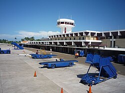
The exterior of Philip S. W. Goldson International Airport Philip S. W. Goldson International Airport.jpg
The exterior of Philip S. W. Goldson International Airport

As of 2008, an estimated[ vague ] 44 airports and airstrips were in operation. The international airport is Philip S. W. Goldson International Airport in Ladyville, 9 miles north of Belize City. Currently, the international airport is served by several international and local carriers. A runway expansion program set to be completed in 2007

may allow larger aircraft to land and may encourage new direct or nonstop service from Europe and Canada. There is a smaller airport with local service in Belize City itself.

Two airlines, Tropic Air and Maya Island Air, provide service within the country. Both airlines have service originating both the main airport (Philip S. W. Goldson), and Belize City Municipal Airport in the city. From here they serve San Pedro, Caye Caulker, Dangriga, Placencia, Punta Gorda, and to Flores in Guatemala, and one airline serves Savannah at Big Creek. There is also service from San Pedro to Sarteneja and to Corozal Town. The local airlines generally fly small single-engine equipment, such as the Cessna Caravan.

Railways

Belize has no railways. Dismantled lines include the Stann Creek Railway that linked Dangriga and Middlesex Estate; it was abandoned in 1937. Some of its bridges remain along the Hummingbird Highway.

Related Research Articles

<span class="mw-page-title-main">Transport in Belarus</span> Overview of transport in Belarus

This article is about transport in Belarus.

<span class="mw-page-title-main">Transport in Chile</span>

Transport in Chile is mostly by road. The far south of the country is not directly connected to central Chile by road without travelling through Argentina, and water transport also plays a part there. The railways were historically important in Chile, but now play a relatively small part in the country's transport system. Because of the country's geography and long distances between major cities, aviation is also important.

<span class="mw-page-title-main">Transport in the Dominican Republic</span>

Transport in the Dominican Republic utilizes a system of roads, airports, ports, harbours, and an urban railway.

Transportation in Ecuador is the transport infrastructure networks in Ecuador and those connecting the country with other countries. Transportation in Ecuador include aviation, highways, pipelines, ports and harbors, railways and waterways. Apart from transporting passengers, the country is a relatively small exporter of fruits and vegetables such as banana, papayas and pineapples.

Transport in Egypt is centered in Cairo and largely follows the pattern of settlement along the Nile. The Ministry of Transportation and other government bodies are responsible for transportation in Egypt, whether by sea, river, land or air.

For Soviet transportation, see Transport in the Soviet Union.

Transportation in Guatemala includes roads, waterways, and airports. It formerly included railways.

Transport in Hungary relies on several main modes, including transport by road, rail, air and water.

The vast territory of Kazakhstan spans across 2,700,000 km2 (1,000,000 sq mi). The population density is low in Kazakhstan, and the centers of industry and agriculture are spread out and remote from world markets.

<span class="mw-page-title-main">Transport in Kenya</span>

Transport in Kenya refers to the transportation structure in Kenya. The country has an extensive network of paved and unpaved roads.

This article describes the transport in Peru.

Transportation in South Korea is provided by extensive networks of railways, highways, bus routes, ferry services and air routes that traverse the country. South Korea is the third country in the world to operate a maglev train, which is an automatically run people mover at Incheon International Airport.

<span class="mw-page-title-main">Ladyville</span> Village in Belize District, Belize

Ladyville is the largest village in the country of Belize, eight miles northwest of Belize City in the Belize District. The Philip Goldson Highway connects Ladyville to Belize City.

<span class="mw-page-title-main">Philip S. W. Goldson International Airport</span> Primary airport of Belize

Philip S. W. Goldson International Airport is an airport that serves the nation of Belize's largest city, Belize City along the eastern coast of Central America. It was named after politician Philip S. W. Goldson, who died in 2001. The airport is at an elevation of 5 m (16 ft), which means both the airport and the entirety of Belize City are at risk of serious flooding due to its low elevation and coastal location. For this reason, Belize's capital has been moved to Belmopan, but the airport remains the largest and busiest in the country. With stable passenger growth, Philip S. W. Goldson International Airport is currently the fifth busiest airport in Central America. Belize Airport covers 457 acres of land and has one runway.

The road network in Belize consists of over 1,900 miles (3,000 km) of roads, of which approximately 357 miles (575 km) is paved.

<span class="mw-page-title-main">National Transportation Services Limited</span> Transport company

National Transportation Services Limited is a national transport carrier serving all major districts of Belize. Established in January 2006 following the collapse of the former Novelo's Bus Lines Limited, the reigning monopoly company in Belizean transportation, the NTSL is run by the former owners of that company, David and Antonio Novelo, on much the same permits as the original Novelo's.However this company too has failed like its predecessor. In 2010 to 2011 a massive void was dented into the transport system for Belize when the company went into bankruptcy.

<span class="mw-page-title-main">Transportation in Taiwan</span>

The Ministry of Transportation and Communications governs transportation in Taiwan.

References

  1. New Bus Transport System [ permanent dead link ], press release, Belmopan, October 17, 2008.
  2. The Rule of the Road: An International Guide to History and Practice, Peter Kincaid, Greenwood Press, 1986, page 50

PD-icon.svg This article incorporates public domain material from The World Factbook. CIA.