Transport infrastructure in Brazil is characterized by strong regional differences and lack of development of the national rail network.[1] Brazil's fast-growing economy, and especially the growth in exports, will place increasing demands on the transport networks.[2] However, sizeable new investments that are expected to address some of the issues are either planned or in progress.[2][3] It is common to travel domestically by air because the price is low.[4] Brazil has the second highest number of airports in the world, after the USA.[5]
Norte Brasil RailwayMap of Brazilian rail network, 2016
The Brazilian railway network has an extension of about 30,000km (18,641mi). It is basically used for transporting ores.[5] Usually, the railway sector was treated in a secondary way in Brazil, due to logistical, economic or political difficulties to install more railways.
The Brazilian railroad system had a great expansion between 1875 and 1920. The heyday of the railway modal was interrupted during the Getúlio Vargas government, which prioritized the road modal. In the 1940s, the railway network was already facing several problems, from low-powered locomotives to uneconomical layouts. In 1957, a state-owned company was created, the National Railroad Network (RFFSA), which started to manage 18 railroads in the Union. Several deficit railways were closed under the promise of state investment in new projects, which did not happen. The actions were centralized in the government until the opening of the market in 1990. So, the National Privatization Plan was instituted, with dozens of concessions being made. However, they ended up concentrating the railways, mainly, in three large business groups, América Latina Logística (ALL), Vale S.A. and MRS Logística. The refurbishment generated an increase in productivity (cargoes transported increased by 30% with the same railway line). However, the main problem was that the reform not only gave away the railway line, but also geographical exclusivity. This resulted in the non-creation of competitive incentives for the expansion and renewal of the existing network. With the State maintaining the opening of new railways a difficult, slow and bureaucratic process, as it maintains the total monopoly of power over this sector, the railways did not expand any further in the country, and the sector was very outdated.[6][7]
In 2021, a New Framework for Railways was created, allowing the construction of railways by authorization, as occurs in the exploration of infrastructure in sectors such as telecommunications, electricity and ports. It's also possible to authorize the exploration of stretches not implemented, idle, or in the process of being returned or deactivated. With the change of rules in the sector, in December 2021, there were already requests to open 15,000km (9,321mi) of new tracks, in 64 requests for implementation of new railways. Nine new railroads had already been authorized by the Federal Government, in 3,506km (2,179mi) of new tracks.[8][9][10]
Brazil had a hundred tramway systems.[28] Currently, there are vintage tramways operating in Belém, Campinas, Campos do Jordão, Itatinga, Rio de Janeiro and Santos.[29][30][31][32][33][34]
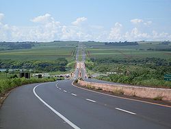
Brazil has more than 1,720,700km (1,069,193mi) of roads, of which 213,452km (132,633mi) are paved (12,4%), and about 17,000km (10,563mi) are divided highways, 6,300km (3,915mi) only in the State of São Paulo. Currently it is possible to travel from Rio Grande, in the extreme south of the country, to Brasília (2,580km (1,603mi)) or Casimiro de Abreu, in the state of Rio de Janeiro (2,045km (1,271mi)), only on divided highways. The total of paved roads increased from 35,496km (22,056mi) in 1967 to 215,000km (133,595mi) in 2018.[35] The two most important highways in the country are BR-101 and BR-116.[36]
Although Brazil has the largest duplicated road network in Latin America, it's considered insufficient for the country's needs: in 2021, it was calculated that the ideal amount of duplicated roads would be something around from 35,000km (21,748mi) to 42,000km (26,098mi). The main road axes also have problems because they often have inadequate geometry and constructive characteristics that don't allow quality long-distance flow (non-interference from local traffic and high speed). The Brazilian Federal Government has never implemented a National Highway Plan at the same level as developed countries such as the US, Japan or European countries, which specifically aimed at inter-regional travel, and which should preferably be served by highways (which would differ from the common duplicated highways by geometric pattern, access control without access to neighboring lots, zero level crossings and returns, prohibition of circulation of non-motorized vehicles such as cyclists, animal traction or human propulsion, as per the Vienna Convention). The Brazilian State, despite some planning efforts, has been guided by a reactive action to the increase in demand (only duplicating some roads with old and inadequate layout) and not by a purposeful vision, directing occupation and economic density in the territory. Another problem is the lack of directing the Union Budget towards infrastructure works: in Brazil there is no law that guarantees funds from the Federal Budget for works on highways and other modes of transport (unlike what happens in sectors such as Education and Health), depending exclusively on the goodwill of the rulers. In the US, for example, the gasoline tax can only be used for transport infrastructure works. Brazil even invested 1.5% of the country's budget in infrastructure in the 1970s, being the time when the most investment was made in highways; but in the 1990s, only 0.1% of the budget was invested in this sector, maintaining an average of 0.5% in the 2000s and 2010, insufficient amounts for the construction of an adequate road network. For comparative purposes, the average investment of the US and the European Union was 1% between 1995 and 2013, even though they already have a much more advanced road infrastructure than Brazil.[37][38]
The country has a medium rate of car ownership of 471 per 1000 people,[39] however in comparison to the other developing economies of the BRIC group Brazil exceeds India and China.[when?][citation needed]
The country still has several states where paved access to 100% of the state's municipalities has not yet been reached. Some states have 100% of cities with asphalt access, such as Santa Catarina, which reached this goal in 2014;[40]Paraíba, which reached this goal in 2017,[41] and Alagoas, which reached this goal in 2021 [42] In states like Rio Grande do Sul, in 2020, there were still 54 cities without asphalt access.[43] In Paraná, in 2021, there were still 4 cities without asphalt access.[44] In Minas Gerais, in 2016, there were still 5 cities without asphalt access.[45]
Waterways
Tietê-Paraná Waterway
50,000km navigable (most in areas remote from industry or population) (2012)[5]
Among the main Brazilian waterways, two stand out: Hidrovia Tietê-Paraná (which has a length of 2,400km, 1,600 on the Paraná River and 800km on the Tietê River, draining agricultural production from the states of Mato Grosso, Mato Grosso do Sul, Goiás and part of Rondônia, Tocantins and Minas Gerais) and Hidrovia do Solimões-Amazonas (it has two sections: Solimões, which extends from Tabatinga to Manaus, with approximately 1600km, and Amazonas, which extends from Manaus to Belém, with 1650km. Almost entirely passenger transport from the Amazon plain is done by this waterway, in addition to practically all cargo transportation that is directed to the major regional centers of Belém and Manaus). In Brazil, this transport is still underutilized: the most important waterway stretches, from an economic point of view, are found in the Southeast and South of the country. Its full use still depends on the construction of locks, major dredging works and, mainly, of ports that allow intermodal integration.[46][47][48]
↑"VLT do Cariri". Metrô de Fortaleza (in Brazilian Portuguese). Retrieved 26 December 2021.
↑"VLT de Sobral". Metrô de Fortaleza (in Brazilian Portuguese). Retrieved 26 December 2021.
↑"Malha Viária: Belo Horizonte". Companhia Brasileira de Trens Urbanos - CBTU (in Portuguese). 20 July 2020. Archived from the original on 7 February 2019. Retrieved 26 December 2021.
↑"Malha Viária: João Pessoa". Companhia Brasileira de Trens Urbanos - CBTU (in Portuguese). 1 June 2021. Archived from the original on 26 December 2021. Retrieved 26 December 2021.
↑"Malha Viária: Maceió". Companhia Brasileira de Trens Urbanos - CBTU (in Portuguese). 20 July 2020. Retrieved 26 December 2021.
↑"Quem Somos". CCR Metrô Bahia (in Portuguese). Retrieved 26 December 2021.
↑"Estrutura | Raio-x". Companhia do Metropolitano do Distrito Federal (in Portuguese). 20 October 2021. Retrieved 26 December 2021.
↑"Estações e Sistema". Empresa de Trens Urbanos de Porto Alegre - Trensurb (in Portuguese). Archived from the original on 6 December 2021. Retrieved 26 December 2021.
↑"Sistema metroviário". Metrô de Fortaleza (in Brazilian Portuguese). Retrieved 26 December 2021.
↑"Malha Viária: Natal". Companhia Brasileira de Trens Urbanos - CBTU (in Portuguese). March 2019. Archived from the original on 21 January 2022. Retrieved 26 December 2021.
↑"Malha Viária: Recife". Companhia Brasileira de Trens Urbanos - CBTU (in Portuguese). Archived from the original on 14 December 2021. Retrieved 26 December 2021.
This page is based on this Wikipedia article Text is available under the CC BY-SA 4.0 license; additional terms may apply. Images, videos and audio are available under their respective licenses.