Transport in Peru

Last updated

Duplicate Highways of Peru, in red Carreteras Duplas de Peru 2024.jpg
Duplicate Highways of Peru, in red

This article describes the transport in Peru .

Railways

total: 2,374 km (1,475 mi)
standard gauge:1,608 km (999 mi), 4 ft 8+12 in (1,435 mm) gauge
narrow gauge: 380 km (240 mi), 3 ft (914 mm) gauge

Contents

There are two unconnected principal railways in Peru.

The Ferrocarril Central Andino (FCCA; the former Ferrocarril Central del Perú) runs inland from Callao and Lima across the Andes watershed to La Oroya and Huancayo. It is the second highest railway in the world (following opening of the Qingzang railway in Tibet), with the Galera summit tunnel under Mount Meiggs at 4,783 m (15,692 ft) and Galera station at 4,777 m (15,673 ft) above sea level. In 1955 the railway opened a spur line from La Cima on the Morococha branch (4,818 m (15,807 ft) above sea level) to Volcán Mine, reaching an (at the time) world record altitude of 4,830 m (15,850 ft). Both branch and spur have since closed to traffic. [1] [ page needed ] From Huancayo the route is extended by the Ferrocarril Huancayo-Huancavelica. In July 2006 FCCA began work to regauge the Huancavelica line from 914 mm (3 ft) to 1,435 mm (4 ft 8+12 in) standard gauge and it was finished in 2010. There was also a proposal for a 21 km (13 mi) tunnel under the Andes. [2]

The Ferrocarriles del Sur del Perú (FCS), now operated by PeruRail, runs from the coast at Matarani to Cuzco, and to Puno on Lake Titicaca. From Cuzco, PeruRail runs the 914 mm (3 ft) gauge line to Aguas Calientes for Machu Picchu. [3]

Railways in Peru Railways in Peru.svg
Railways in Peru

Towns served

Central railways

A PeruRail passenger train stopping in La Raya Estacion La Raya Peru.jpg
A PeruRail passenger train stopping in La Raya

See Ferrocarril Central Andino

  • in March 2009, gauge conversion from Huancayo to Huancavelica from 914 mm (3 ft) to 1,435 mm (4 ft 8+12 in) proceeds. By October 2010 it was finished and it is in service now.

Southern railway

See PeruRail

Metro

A car in the Villa El Salvador station in Lima Anden de Estacion Villa El Salvador - Metro de Lima.jpg
A car in the Villa El Salvador station in Lima

Lima has a metro service or Lima Metro, also called Tren eléctrico that has now only one line (called Linea 1). The line has an extension of 34.6 km (21.5 mi), with 26 stations, and goes from the south east to north east Lima urban districts passing downtown (This is Villa El Salvador to San Juan de Lurigancho). The second line (called Linea 2) is now under construction and will run from the port of Callao to Ate passing downtown too (west to east).(2015).

Huancayo Metro is the second urban rail line in Peru, is located in the Andean city of Huancayo and is currently under construction (2012).

Proposed

Highways


total:85,900 km (53,400 mi)
paved: 45,000 km (Of which approximately 350 km of divided multi-line roads)
unpaved: 40,900 km (1999 est.)

The Pan-American Highway runs the country from north to south next to the coast, from Tumbes (Ecuadoran border) to Tacna (Chilean border). From Arequipa a branch goes to Puno and then to Bolivia. Other important highways in Peru are the Longitudinal de la Sierra, [4] that goes from north to south in the highlands; and the Carretera Central, that goes from Lima (in the coast) to Pucallpa (in the jungle). [5]

Long distance buses

Inter-city travel in Peru is almost exclusively done in long-distance buses. Buses in most of the cities depart from bus terminals called terminal terrestre. The main bus companies which link Lima with the major cities include Cruz del Sur and Ormeño. Other companies are Civa and Oltursa., [6] while the full list of carriers include Transported Libertad and Turismo Mer, among others. [7]

Maps

Waterways

8,600 km (5,300 mi) of navigable tributaries of Amazon system and 208 km (129 mi) of Lake Titicaca.

There are river boat service from Yurimaguas and Pucallpa to Iquitos, and from there to the Brazilian border in the Amazon River. Touristic boats can be reached at Puno in Lake Titicaca.

Pipelines

Ports and harbors

Portuary administration in Peru is carried out by the National Port Authority.

Pacific Ocean

Lake Titicaca

Amazon basin

Merchant marine


total: 7 ships (1,000  gross tonnage  (GT) or over) totaling 65,193  GT/100,584 tonnes deadweight (DWT)
ships by type: (1999 est.)
Airports and airlines

Airports
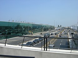
The exterior of Jorge Chavez International airport in 2008 JorgeChavezAirportLima.jpg
The exterior of Jorge Chavez International airport in 2008

According to a 1999 estimate there are 234 airports in Peru. Jorge Chavez International Airport, in Lima is Peru's main national and international gateway, [8] with an estimate of 98 percent of all international flights into Peru landing at this airport. Other important airports are located in Cusco, Arequipa, Iquitos and Piura.

Airports – with paved runways:
total: 44
over 3,047 m: 7
2,438 to 3,047 m: 17
1,524 to 2,437 m: 12
914 to 1,523 m: 7
under 914 m: 1 (1999 est.)

Airports – with unpaved runways:
total: 190
over 3,047 m: 1
2,438 to 3,047 m: 2
1,524 to 2,437 m: 26
914 to 1,523 m: 67
under 914 m: 94 (1999 est.)

Airlines
A Peruvian Airlines plane Enaviadiligo en la flughaveno Jorge Chavez.jpg
A Peruvian Airlines plane

International airlines connecting Peru with North America, Europe and other Latin American countries include: Delta Air Lines, American Airlines, United Airlines, Air Canada, Iberia, Air France, KLM, LATAM Airlines, Avianca, AeroMexico, and British Airways.
Airlines in Peru with domestic service in Peru include LAN Peru, Star Peru, Peruvian Airlines, and LC Perú. Charter and Cargo airlines include ATSA, Andes Air and Cielos Airlines. Former Peruvian airlines include Aero Continente, AeroPerú and Faucett.

See also

Related Research Articles

<span class="mw-page-title-main">Transport in Chile</span>

Transport in Chile is mostly by road. The far south of the country is not directly connected to central Chile by road without travelling through Argentina, and water transport also plays a part there. The railways were historically important in Chile, but now play a relatively small part in the country's transport system. Because of the country's geography and long distances between major cities, aviation is also important.

Transportation in Ecuador is the transport infrastructure networks in Ecuador and those connecting the country with other countries. Transportation in Ecuador include aviation, highways, pipelines, ports and harbors, railways and waterways. Apart from transporting passengers, the country is a relatively small exporter of fruits and vegetables such as banana, papayas and pineapples.

For Soviet transportation, see Transport in the Soviet Union.

<span class="mw-page-title-main">Transport in Greece</span>

Transport in Greece has undergone significant changes in the past two decades, vastly modernizing the country's infrastructure and transportation. Although ferry transport between islands remains the prominent method of transport between the nation's islands, improvements to the road infrastructure, rail, urban transport, and airports have all led to a vast improvement in transportation. These upgrades have played a key role in supporting Greece's economy, which in the past decade has come to rely heavily on the construction industry.

Transportation in Guatemala includes roads, waterways, airports and a short cross-border rail line from Mexico.

<span class="mw-page-title-main">Transport in Guinea</span>

Transport in Guinea is composed by a variety of systems that people in the country use to get around as well as to and from domestic and international destinations. The railway from Conakry to Kankan ceased operating in the mid-1980s. Most vehicles in Guinea are 20+ years old, and cabs are any four-door vehicle which the owner has designated as being for hire. Domestic air services are intermittent. Conakry International Airport is the largest airport in the country, with flights to other cities in Africa as well as to Europe.

Transport in Hungary relies on several main modes, including transport by road, rail, air and water.

The vast territory of Kazakhstan spans across 2,700,000 km2 (1,000,000 sq mi). The population density is low in Kazakhstan, and the centers of industry and agriculture are spread out and remote from world markets.

<span class="mw-page-title-main">Transport in Syria</span>

Transport in Syria is possible by rail, road, air or rivers, both public and private. Syria is an Asian country with a well-developed rail network (2,052 km) and a highway system (782 km). Main international airport is the Damascus International Airport in the capital, Damascus.

<span class="mw-page-title-main">Mountain railway</span> Railway which operates within a mountainous region

A mountain railway is a railway that operates in a mountainous region. It may operate through the mountains by following mountain valleys and tunneling beneath mountain passes, or it may climb a mountain to provide transport to and from the summit.

<span class="mw-page-title-main">Huancayo</span> Place in Junin, Peru

Huancayo is the capital of the Junín Region and Huancayo Province, in the central highlands of Peru, in the Mantaro Valley and is crossed by the Shullcas, Chilca and Mantaro rivers. It was founded as a reduction by the name Santísima Trinidad de Huancayo on 1 June 1572, by Don Jerónimo de Silva, a Spanish conquistador. It is the fifth largest city in Peru, with a population of 500,000 and is among the highest cities in Peru, with an altitude of 3,256 meters above sea level. It is considered the economic and social center of central Peru

<span class="mw-page-title-main">Trans-Andean railways</span>

The Trans-Andean railways provide rail transport over the Andes. Several are either planned, built, defunct, or waiting to be restored. They are listed here in order from north to south.

The Empresa Nacional de Ferrocarriles del Perú (Enafer) is a public company which ensures the management and the commercial use of the railway network of Peru.

<span class="mw-page-title-main">PeruRail</span> Peruvian rail service

PeruRail is a railway operator providing tourist, freight, and charter services in southern Peru. It was founded in 1999 by two Peruvian entrepreneurs and the British company Sea Containers.

<span class="mw-page-title-main">Rail transport in Peru</span>

Rail transport in Peru has a varied history. Peruvian rail transport has never formed a true network, primarily comprising separate lines running inland from the coast and built according to freight need rather than passenger need.

<span class="mw-page-title-main">Ferrocarril Central Andino</span>

Ferrocarril Central Andino (FCCA) is the consortium which operates the Ferrovías Central railway in Peru linking the Pacific port of Callao and the capital Lima with Huancayo and Cerro de Pasco. As one of the Trans-Andean Railways it is the second highest in the world constructed by the Polish engineer Ernest Malinowski in 1871–1876.

<span class="mw-page-title-main">Transportation in Taiwan</span>

The Ministry of Transportation and Communications governs transportation in Taiwan.

<span class="mw-page-title-main">Rail transport in Bolivia</span>

The Bolivian rail network has had a peculiar development throughout its history.

Metre and 3 ft gauge lines are found in South America. Some of the 1,000 mm gauge lines cross international borders, though not as efficiently as they might.

<span class="mw-page-title-main">Huancayo-Huancavelica Railway</span> Railway in Peru

The Huancayo-Huancavelica Railway, also known as Tren Macho is a state-owned, non-electrified, single-track, 128.7 km long, standard gauge railway connecting the cities of Huancayo and Huancavelica in the central highlands of Peru. The railway is operated by the Peruvian Ministry of Transport and Communications (MTC) but is expected to be operated as a concession from the end of 2019.

References

  1. Marshall, John (1989). The Guinness Railway Book. Enfield: Guinness Books. ISBN   0-8511-2359-7. OCLC   24175552.
  2. "Huancavelica upgrade". Railway Gazette International . 2006-06-01.
  3. Whetham, Robert D. (2008). Railways of Peru. Volume 2 – The Central and Southern Lines. Bristol: Trackside Publications. ISBN   978-1-900095-37-2.
  4. "Longitudinal de la Sierra llevará desarrollo y crecimiento económico". andina.pe (in Spanish). Retrieved 2022-11-03.
  5. "Carretera Central: ¿Cuál es la mejor ruta alterna para descongestionar esta vía?". El Comercio Perú (in Spanish). 2022-10-17. Retrieved 2022-11-03.
  6. "Oltursa".
  7. "Bus Companies Peru - Full list of all carriers".
  8. "El aeropuerto internacional Jorge Chávez: historia y actuales necesidades". Ingeniería e instalaciones de telecomunicación y baja tensión (in Spanish). 2019-07-10. Retrieved 2022-11-03.

PD-icon.svg This article incorporates public domain material from The World Factbook. CIA.